Old Maps of Lower Connecticut River Valley Planning Region, Connecticut for Genealogy
Trace your family roots with 90 historic maps of Lower Connecticut River Valley Planning Region. These high-res maps reveal old neighborhoods, homesites, landmarks, and streets — helping you uncover where your ancestors lived and how the area evolved over time.
- Explore historic neighborhoods: Identify where your relatives may have lived in the 1800s or 1900s.
- Compare maps over time: Trace the changes in streets, buildings, and landmarks for multi-generational research.
- Perfect for genealogy & ancestry research: Used by family historians and researchers to map out lineage and migration.
These maps are an incredible resource for exploring your personal connection to Lower Connecticut River Valley Planning Region's past.
Lower Connecticut River Valley Planning Region, CT maps
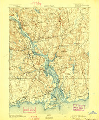
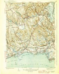
(90)- 1892 Map of New London
 1892 New London1892 Print · USGSCovers Lower Connecticut River Valley Planning Region, including Norwich, Groton, and other nearby areas
 - 1892 Map of Meriden
 1892 Meriden1892 Print · USGSCovers Lower Connecticut River Valley Planning Region, including Waterbury, New Britain, and other nearby areas
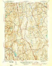
 - 1892 Map of Gilead
 1892 Gilead1892 Print · USGSCovers Lower Connecticut River Valley Planning Region, including Manchester, Glastonbury, and other nearby areas7 unique versions available
 - 1893 Map of Guilford
 1893 Guilford1893 Print · USGSCovers Lower Connecticut River Valley Planning Region, including Meriden, Middletown, and other nearby areas8 unique versions available
 - 1893 Map of Middletown
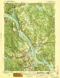
 1893 Middletown1893 Print · USGSCovers Lower Connecticut River Valley Planning Region, including Hartford, West Hartford, and other nearby areas10 unique versions available
 - 1893 Map of Meriden
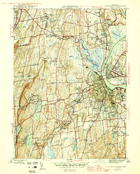
 1893 Meriden1893 Print · USGSCovers Lower Connecticut River Valley Planning Region, including Waterbury, New Britain, and other nearby areas10 unique versions available
 - 1893 Map of New London
 1893 New London1893 Print · USGSCovers Lower Connecticut River Valley Planning Region, including Norwich, Groton, and other nearby areas10 unique versions available
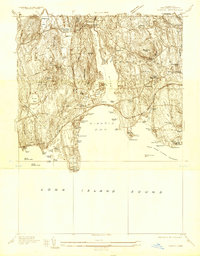
 - 1893 Map of Saybrook, 1898 Print
 1893 Saybrook1898 Print · USGSCovers Lower Connecticut River Valley Planning Region, including East Lyme, Clinton, and other nearby areas8 unique versions available
 - 1903 Map of Gardiners Island, 1962 Print
 1903 Gardiners Island1962 Print · USGSCovers Lower Connecticut River Valley Planning Region, including East Hampton, Southold, and other nearby areas
 - 1904 Map of Gardiners Island
 1904 Gardiners Island1904 Print · USGSCovers Lower Connecticut River Valley Planning Region, including East Hampton, Southold, and other nearby areas6 unique versions available
 - 1906 Map of Farmington
 1906 Farmington1906 Print · USGSCovers Lower Connecticut River Valley Planning Region, including Hartford, Waterbury, and other nearby areas2 unique versions available
 - 1921 Map of Gardiners Island
 1921 Gardiners Island1921 Print · USGSCovers Lower Connecticut River Valley Planning Region, including East Hampton, Southold, and other nearby areas
 - 1921 Map of New London
 1921 New London1921 Print · USGSCovers Lower Connecticut River Valley Planning Region, including Norwich, Groton, and other nearby areas
 - 1928 Map of Cromwell
 1928 Cromwell1928 Print · USGSCovers Lower Connecticut River Valley Planning Region, including Meriden, Middletown, and other nearby areas
 - 1928 Map of Glastonbury
 1928 Glastonbury1928 Print · USGSCovers Lower Connecticut River Valley Planning Region, including Manchester, East Hartford, and other nearby areas
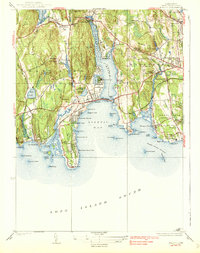
 - 1934 Map of Niantic
 1934 Niantic1934 Print · USGSCovers Lower Connecticut River Valley Planning Region, including New London, Southold, and other nearby areas
 - 1938 Map of Niantic
 1938 Niantic1938 Print · USGSCovers Lower Connecticut River Valley Planning Region, including New London, Southold, and other nearby areas3 unique versions available
 - 1941 Map of Lyme
 1941 Lyme1941 Print · USGSCovers Lower Connecticut River Valley Planning Region, including East Lyme, Old Saybrook, and other nearby areas2 unique versions available
 - 1943 Map of Durham
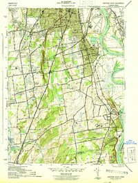
 1943 Durham1943 Print · USGSCovers Lower Connecticut River Valley Planning Region, including Meriden, Middletown, and other nearby areas
 - 1944 Map of Hartford South
 1944 Hartford South1944 Print · USGSCovers Lower Connecticut River Valley Planning Region, including Hartford, West Hartford, and other nearby areas3 unique versions available
 - 1944 Map of Marlboro
 1944 Marlboro1944 Print · USGSCovers Lower Connecticut River Valley Planning Region, including Manchester, Glastonbury, and other nearby areas5 unique versions available
 - 1944 Map of Essex
 1944 Essex1944 Print · USGSCovers Lower Connecticut River Valley Planning Region, including Clinton, Old Saybrook, and other nearby areas3 unique versions available
 - 1944 Map of Deep River
 1944 Deep River1944 Print · USGSCovers Lower Connecticut River Valley Planning Region, including East Haddam, Haddam, and other nearby areas2 unique versions available
 - 1945 Map of Middle Haddam
 1945 Middle Haddam1945 Print · USGSCovers Lower Connecticut River Valley Planning Region, including Middletown, Cromwell, and other nearby areas2 unique versions available
 - 1945 Map of Middletown
 1945 Middletown1945 Print · USGSCovers Lower Connecticut River Valley Planning Region, including Meriden, Middletown, and other nearby areas2 unique versions available
Showing maps 1-25 of 90
Top cities of Lower Connecticut River Valley Planning Region
- Middletown historical maps
- Clinton historical maps
- Cromwell historical maps
- East Hampton historical maps
- Old Saybrook historical maps
- Portland historical maps
See more
Frequently asked questions
- What are the different types of historical maps available for Lower Connecticut River Valley Planning Region?
- What is the oldest map of Lower Connecticut River Valley Planning Region?
- Where can I purchase historical maps of Lower Connecticut River Valley Planning Region for my home or office?
- Where can I download high-res historical maps of Lower Connecticut River Valley Planning Region?
- Are there historical topographic maps available for Lower Connecticut River Valley Planning Region?
- Is there historical aerial imagery available for Lower Connecticut River Valley Planning Region?
- Where are historical maps of Lower Connecticut River Valley Planning Region sourced from?