1940s Maps of Dover, Delaware
Explore 3 historic maps of Dover from the 1940s. These maps offer a rare glimpse into what life looked like during the 1940s — showing old roads, neighborhoods, homes, and landmarks that have changed or disappeared over time.
Whether you're researching your family's past, planning a metal detecting trip, or studying how Dover's landscape evolved across the 1940s, these high-resolution maps are a powerful tool for exploring the history of this region.
- Focus on a specific era: All maps on this page are from the 1940s, giving you a focused view of this time period.
- See what’s changed: Compare century-old streets, trails, and buildings to today's modern landscape using overlays and satellite layers.
- Research with precision: Use these maps for genealogy, historical research, land use analysis, or educational projects.
- View, download, or print: Maps are fully viewable online in high resolution, and can be downloaded or printed for your own records.
Start exploring Dover's history through authentic maps from the 1940s. This is your window into the past.
Dover, DE maps
(3)- 1946 Map of Wilmington, 1948 Print
 1946 Wilmington1948 Print · USGSThe Delaware Valley and Jersey Shore emerge in this mid-century portrait of a region defined by river commerce and seaside growth. Genealogists and historians can trace the rail networks of the Pennsylvania Railroad, locate early airfields like Dover Airpark, and find river defenses at Fort Delaware.2 unique versions available
 - 1949 Map of Frederica
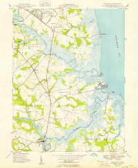 1949 Frederica1949 Print · USGSCoastal Kent County in the late 1940s reveals a landscape of tidal marshes and historic river landings between the bay and the growing military airfield. Genealogists can locate family landmarks like Barratts Chapel, Union Ch, and the coastal communities of Bowers and Kitts Hummock.2 unique versions available
 - 1949 Map of Little Creek
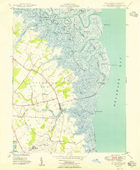 1949 Little Creek1949 Print · USGSThe Delaware coast in the late 1940s shows a landscape of tidal marshes and growing military aviation. Researchers can locate the Friends Meetinghouse, the Moors Cem, and the specialized Dover Army Air Base Strafing Range near the Mahon River.3 unique versions available
End of results
Showing maps 1-3 of 3
Top cities near Dover
- Smyrna historical maps
- Milford historical maps
- Fairfield Township historical maps
- Hopewell Township historical maps
- Highland Acres historical maps
- Harrington historical maps
See more
Top neighborhoods of Dover
- The Hamlet historical maps
- Towne Point historical maps
- Wedgewood historical maps
- White Oak Farms historical maps
- Woodcrest historical maps
- Woodstock Court historical maps
See more
Frequently asked questions
- What are the different types of historical maps available for Dover?
- What is the oldest map of Dover?
- Where can I purchase historical maps of Dover for my home or office?
- Where can I download high-res historical maps of Dover?
- Are there historical topographic maps available for Dover?
- Is there historical aerial imagery available for Dover?
- Where are historical maps of Dover sourced from?