1990s Maps of Dover, Delaware
Explore 3 historic maps of Dover from the 1990s. These maps offer a rare glimpse into what life looked like during the 1990s — showing old roads, neighborhoods, homes, and landmarks that have changed or disappeared over time.
Whether you're researching your family's past, planning a metal detecting trip, or studying how Dover's landscape evolved across the 1990s, these high-resolution maps are a powerful tool for exploring the history of this region.
- Focus on a specific era: All maps on this page are from the 1990s, giving you a focused view of this time period.
- See what’s changed: Compare century-old streets, trails, and buildings to today's modern landscape using overlays and satellite layers.
- Research with precision: Use these maps for genealogy, historical research, land use analysis, or educational projects.
- View, download, or print: Maps are fully viewable online in high resolution, and can be downloaded or printed for your own records.
Start exploring Dover's history through authentic maps from the 1990s. This is your window into the past.
Dover, DE maps
(3)- 1993 Map of Dover
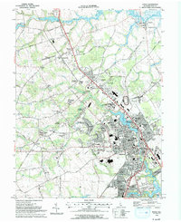 1993 Dover1993 Print · USGSDover and its surrounding Kent County suburbs are captured here in the early nineties, showing a landscape of rapid residential and civic growth. Researchers can trace family history through sites like Sharon Hills Mem Park, old schoolhouses such as Apple Grove Sch, and established rail-side towns like Cheswold.
 - 1993 Map of Little Creek
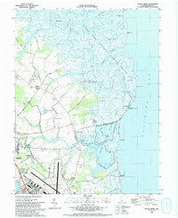 1993 Little Creek1993 Print · USGSThe Delaware coastline near Little Creek comes to life in the early nineties as the vast marshlands meet the expanding outskirts of Dover. Researchers can trace family sites at Friends Meetinghouse Cem, explore the reaches of Port Mahon, or locate the historic Leipsic River Range Light.
 - 1993 Map of Frederica
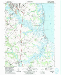 1993 Frederica1993 Print · USGSThe Kent County coastline in the early nineties features a unique blend of historic river landings and expansive wildlife preserves. Genealogists and local historians can locate Barratts Chapel, the Dickinson Mansion, and bayfront communities like Bowers Beach.
End of results
Showing maps 1-3 of 3
Top cities near Dover
- Smyrna historical maps
- Milford historical maps
- Fairfield Township historical maps
- Hopewell Township historical maps
- Highland Acres historical maps
- Harrington historical maps
See more
Top neighborhoods of Dover
- The Hamlet historical maps
- Towne Point historical maps
- Wedgewood historical maps
- White Oak Farms historical maps
- Woodcrest historical maps
- Woodstock Court historical maps
See more
Frequently asked questions
- What are the different types of historical maps available for Dover?
- What is the oldest map of Dover?
- Where can I purchase historical maps of Dover for my home or office?
- Where can I download high-res historical maps of Dover?
- Are there historical topographic maps available for Dover?
- Is there historical aerial imagery available for Dover?
- Where are historical maps of Dover sourced from?