1930s Maps of Sussex County, Delaware
Explore 4 historic maps of Sussex County from the 1930s. These maps offer a rare glimpse into what life looked like during the 1930s — showing old roads, neighborhoods, homes, and landmarks that have changed or disappeared over time.
Whether you're researching your family's past, planning a metal detecting trip, or studying how Sussex County's landscape evolved across the 1930s, these high-resolution maps are a powerful tool for exploring the history of this region.
- Focus on a specific era: All maps on this page are from the 1930s, giving you a focused view of this time period.
- See what’s changed: Compare century-old streets, trails, and buildings to today's modern landscape using overlays and satellite layers.
- Research with precision: Use these maps for genealogy, historical research, land use analysis, or educational projects.
- View, download, or print: Maps are fully viewable online in high resolution, and can be downloaded or printed for your own records.
Start exploring Sussex County's history through authentic maps from the 1930s. This is your window into the past.
Sussex County, DE maps
(4)- 1937 Map of Cape Henlopen
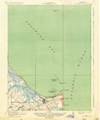 1937 Cape Henlopen1937 Print · USGSThe Delaware coastline near Cape Henlopen comes alive in the early twentieth century, showing a landscape defined by maritime safety and rail transport. Trace the routes of the Pennsylvania RR to settlements like Lewes or locate landmarks such as the West Hill School and Cape Henlopen Light.2 unique versions available
 - 1938 Map of Cedar Creek
 1938 Cedar Creek1938 Print · USGSCoastal Sussex County in the late 1930s shows a landscape of tidal necks and millponds connected by the P B AND W RR. Genealogists can trace family footprints across dozens of local school sites like Wesleys School and the Old Baptist Church.2 unique versions available
 - 1938 Map of Millsboro, 1945 Print
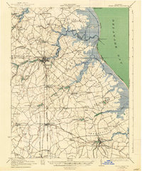
 1938 Millsboro1945 Print · USGSSussex County’s agricultural and rail heartland is captured here between the World Wars, showing Georgetown and Millsboro before modern expansion. Genealogists can trace family roots through numerous named schoolhouses and local junctions like Knowles and Jones Crossroads.
 - 1938 Map of Rehoboth, 1958 Print
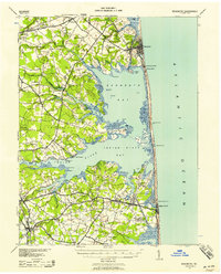 1938 Rehoboth1958 Print · USGSCoastal Sussex County comes alive in the late 1930s, showcasing the early resort development of Rehoboth and Bethany Beach. Genealogists can trace rural family life through a dense network of country schoolhouses like Antioch Sch and Roxana Sch.2 unique versions available
End of results
Showing maps 1-4 of 4
Top cities of Sussex County
- Seaford historical maps
- Georgetown historical maps
- Laurel historical maps
- Lewes historical maps
- Millsboro historical maps
- Selbyville historical maps
See more
Frequently asked questions
- What are the different types of historical maps available for Sussex County?
- What is the oldest map of Sussex County?
- Where can I purchase historical maps of Sussex County for my home or office?
- Where can I download high-res historical maps of Sussex County?
- Are there historical topographic maps available for Sussex County?
- Is there historical aerial imagery available for Sussex County?
- Where are historical maps of Sussex County sourced from?