1950s Maps of Sussex County, Delaware
Explore 30 historic maps of Sussex County from the 1950s. These maps offer a rare glimpse into what life looked like during the 1950s — showing old roads, neighborhoods, homes, and landmarks that have changed or disappeared over time.
Whether you're researching your family's past, planning a metal detecting trip, or studying how Sussex County's landscape evolved across the 1950s, these high-resolution maps are a powerful tool for exploring the history of this region.
- Focus on a specific era: All maps on this page are from the 1950s, giving you a focused view of this time period.
- See what’s changed: Compare century-old streets, trails, and buildings to today's modern landscape using overlays and satellite layers.
- Research with precision: Use these maps for genealogy, historical research, land use analysis, or educational projects.
- View, download, or print: Maps are fully viewable online in high resolution, and can be downloaded or printed for your own records.
Start exploring Sussex County's history through authentic maps from the 1950s. This is your window into the past.
Sussex County, DE maps
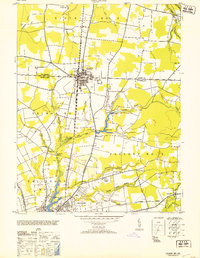
(30)- 1950 Map of Pittsville
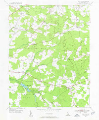
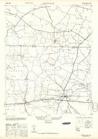 1950 Pittsville1950 Print · USGSThe Maryland-Delaware borderlands come into focus at the midpoint of the twentieth century. Genealogists can trace family homesteads near Pittsville and Parsonsburg, or locate the historic Line Church Line and Race Bridge.
 - 1953 Map of Delmar
 1953 Delmar1953 Print · USGSMid-century Delmar and Salisbury appear here during a period of transition for the Eastern Shore. Genealogists and historians can trace family locations near Johnson Pond, the rail lines of the Pennsylvania, and rural communities like Walston or Five Points.
 - 1953 Map of Assawoman Bay
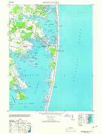 1953 Assawoman Bay1953 Print · USGSThe Atlantic coast and back bays along the Maryland-Delaware border are captured here just after the war. You can trace early coastal landmarks including the Fenwick Island Lighthouse, the settlement of Bayville, and the marshy expanses of Isle of Wight.
 - 1954 Map of Millsboro, 1955 Print
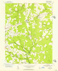
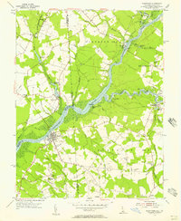
 1954 Millsboro1955 Print · USGSMid-century Millsboro and Dagsboro are captured here at a time when the railroad and river still shaped local commerce. Researchers can locate vanished landmarks and rural crossroads like Shaft Ox Corner, Old Field Ch, and the Carey Camp grounds.3 unique versions available
 - 1954 Map of Trap Pond, 1955 Print
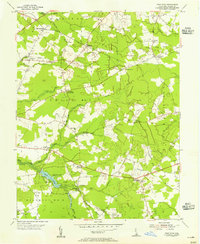
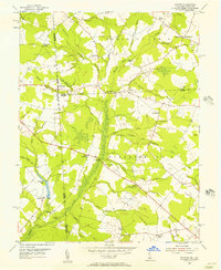
 1954 Trap Pond1955 Print · USGSSussex County in the mid-1950s is defined by its rural crossroads and low-lying wetlands. Genealogists can trace family connections through landmarks like Ross Point Sch, Hardscrabble, and numerous local meeting houses including Trinity Ch.2 unique versions available
 - 1954 Map of Milford, 1955 Print
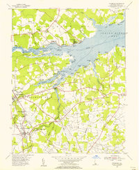
 1954 Milford1955 Print · USGSThe coastal plain of Delaware's Kent and Sussex counties is captured in the mid-fifties, centered on the hub of Milford. Genealogists and historians can trace the evolution of the MISPILLION RIVER waterfront, family landmarks like Abbotts Pond, and the old I O O F Cemetery.3 unique versions available
 - 1954 Map of Georgetown, 1955 Print
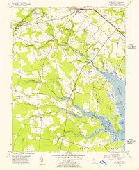
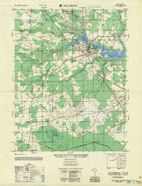
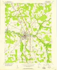
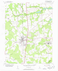
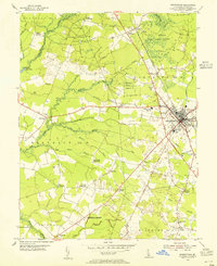 1954 Georgetown1955 Print · USGSGeorgetown and its surrounding rural districts are shown in the mid-fifties, just as highway infrastructure like the Dupont Highway was being modernized. Genealogists can locate community centers like McColley Ch and regional hubs such as Redden Crossroads or Whaleys Corners.3 unique versions available
 - 1954 Map of Ellendale, 1955 Print
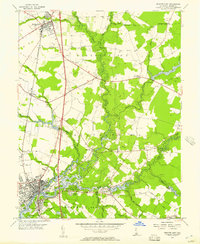
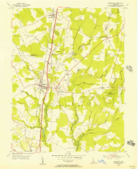
 1954 Ellendale1955 Print · USGSSussex County during the mid-fifties is characterized here by managed timberlands and the growing importance of the Dupont Highway corridor. Researchers can pinpoint old rural landmarks like Red Men Cemetery, the State Tree Nursery, and the tracks of the Pennsylvania railroad.2 unique versions available
 - 1954 Map of Lewes, 1956 Print
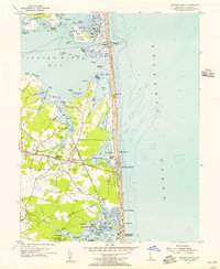
 1954 Lewes1956 Print · USGSThe Delaware coast during the mid-fifties reveals a landscape of marsh landings, barrier beaches, and strategic defenses. Researchers can trace the Pennsylvania rail line past Nassau or locate old rural congregations at Burtons Chapel and Whites Chapel.4 unique versions available
 - 1954 Map of Rehoboth Beach, 1956 Print
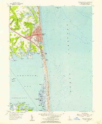 1954 Rehoboth Beach1956 Print · USGSSussex County's coastline and interior marshes come alive in the mid-1950s, showing the early layout of Rehoboth Beach and Dewey Beach. Genealogists and historians can trace family-named sites like Lingo Landing, the Rehoboth Airfield, and Thompson Island.3 unique versions available
 - 1954 Map of Bethany Beach, 1956 Print
 1954 Bethany Beach1956 Print · USGSThe Delaware coast in the mid-fifties shows the early growth of beach communities alongside traditional bay life. Genealogists and historians can trace family sites at Banks Cem, the old Lord Baltimore High Sch, and the grounds of Camp Barnes.4 unique versions available
 - 1954 Map of Fairmount, 1956 Print
 1954 Fairmount1956 Print · USGSSussex County’s coastal interior and tidal marshes are captured here in the mid-1950s, showing a network of small settlements and family landings. Researchers can trace local heritage at the Indian Mission Ch, Cool Spring Ch, and schools like the Rabbits Ferry Sch.3 unique versions available
 - 1954 Map of Cape Henlopen, 1956 Print
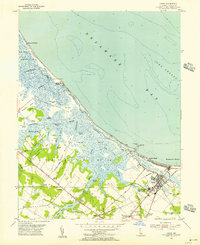
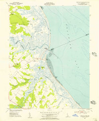
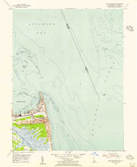 1954 Cape Henlopen1956 Print · USGSCoastal Delaware in the mid-fifties reveals a landscape of maritime defense and navigation at the mouth of the bay. Researchers can trace the sprawling Fort Miles, the rail lines of the Pennsylvania, and the historic waterfront at Lewes.4 unique versions available
 - 1955 Map of Wilmington
 1955 Wilmington1955 Print · USGSThe Delaware Valley and Jersey Shore are seen here during the mid-fifties era of rapid suburban expansion and highway development. You can trace the path of the New Jersey Turnpike, locate the Fort Dix Military Reservation, or explore the rail networks of the Pennsylvania Railroad.
 - 1955 Map of Trap Pond
 1955 Trap Pond1955 Print · USGSSussex County crossroads and wetland drainages define this mid-century Delaware landscape. Genealogists can trace family connections at Whaleys Crossroads, Ross Point Sch, and Mt Olivet Ch.
 - 1955 Map of Millsboro
 1955 Millsboro1955 Print · USGSSussex County agriculture and river life meet in the mid-fifties along the banks of the Indian River and the Pennsylvania rail line. Researchers can trace old rural centers like Shaft Ox Corner, Carey Camp, and the Old Field Ch.
 - 1955 Map of Harbeson, 1956 Print
 1955 Harbeson1956 Print · USGSCoastal Sussex County in the mid-1950s reveals a landscape of railroad sidings, drainage ditches, and rural crossroads. Genealogists and historians can locate St John Ch, trace the Pennsylvania rail line through Harbeson, and find the Morris Millpond area.4 unique versions available
 - 1955 Map of Mispillion River, 1956 Print
 1955 Mispillion River1956 Print · USGSCoastal Sussex County in the mid-fifties is captured here as a network of salt marshes, river landings, and maritime outposts. Genealogists can trace family landmarks like Cedar Neck Ch and Fort Saulsbury, or locate early sites like Majorleys Landing.3 unique versions available
 - 1955 Map of Frankford, 1956 Print
 1955 Frankford1956 Print · USGSCoastal Sussex County in the mid-fifties reveals a landscape of tidal necks, railroad towns, and early bayside resorts. Genealogists and historians can trace family-named landmarks and institutions like Antioch Ch, the John M Clayton Sch, and the historic Prince George Chapel.3 unique versions available
 - 1955 Map of Laurel, 1957 Print
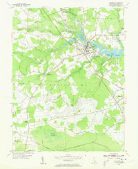
 1955 Laurel1957 Print · USGSSussex County in the mid-fifties centers on the transit hub of Laurel and the maritime heritage of Broad Creek. Genealogists can trace family landmarks like the Odd Fellows Cemetery, Old Christ Ch, and rural settlements such as Hearns Crossroads.3 unique versions available
 - 1955 Map of Seaford East, 1957 Print
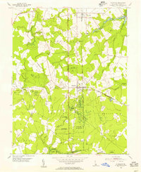
 1955 Seaford East1957 Print · USGSSussex County's river-driven geography is captured here in the mid-1950s, centered on the growth of Seaford and Bridgeville. Genealogists and historians can trace old community landmarks like the Frederick Douglass Sch, Chaplins Chapel, and the historic Middleford settlement.2 unique versions available
 - 1955 Map of Hickman, 1957 Print
 1955 Hickman1957 Print · USGSMid-century Sussex County comes into focus in the mid-fifties, showing the farming and drainage patterns along the Maryland border. Genealogists can trace family footprints near Smithville, Dublin Hill, and country houses of worship like Trinity Ch.2 unique versions available
 - 1955 Map of Sharptown, 1957 Print
 1955 Sharptown1957 Print · USGSThe Nanticoke River and Broad Creek dominate this mid-century look at the Maryland and Delaware border. Genealogists can trace family roots through Sharptown and Galestown, or locate historic river crossings like the Woodland Ferry and Baileys Landing.2 unique versions available
 - 1955 Map of Harrington, 1957 Print
 1955 Harrington1957 Print · USGSHarrington and the surrounding Kent County farm country are shown in the mid-fifties at a peak of rail-driven activity. Genealogists and local historians can trace family locations near Reeves Crossing, Houston, and the rural St Mark Ch.3 unique versions available
 - 1955 Map of Greenwood, 1957 Print
 1955 Greenwood1957 Print · USGSCentral Delaware's Sussex County in the mid-fifties shows a landscape of rail-side towns and marshy woodlots. Trace family roots and local landmarks from Greenwood to Staytonville, including St Johnstown Ch and Devils Woodyard.2 unique versions available
Showing maps 1-25 of 30
Top cities of Sussex County
- Seaford historical maps
- Georgetown historical maps
- Laurel historical maps
- Lewes historical maps
- Millsboro historical maps
- Selbyville historical maps
See more
Frequently asked questions
- What are the different types of historical maps available for Sussex County?
- What is the oldest map of Sussex County?
- Where can I purchase historical maps of Sussex County for my home or office?
- Where can I download high-res historical maps of Sussex County?
- Are there historical topographic maps available for Sussex County?
- Is there historical aerial imagery available for Sussex County?
- Where are historical maps of Sussex County sourced from?