1900s (20th Century) Maps of Sussex County, Delaware
Explore 128 historic maps of Sussex County from the 1900s (20th Century). These maps offer a rare glimpse into what life looked like during the 1900s — showing old roads, neighborhoods, homes, and landmarks that have changed or disappeared over time.
Whether you're researching your family's past, planning a metal detecting trip, or studying how Sussex County's landscape evolved across the 1900s, these high-resolution maps are a powerful tool for exploring the history of this region.
- Focus on a specific era: All maps on this page are from the 1900s, giving you a focused view of this time period.
- See what’s changed: Compare century-old streets, trails, and buildings to today's modern landscape using overlays and satellite layers.
- Research with precision: Use these maps for genealogy, historical research, land use analysis, or educational projects.
- View, download, or print: Maps are fully viewable online in high resolution, and can be downloaded or printed for your own records.
Start exploring Sussex County's history through authentic maps from the 1900s. This is your window into the past.
Sussex County, DE maps
(128)- 1901 Map of Salisbury
 1901 Salisbury1901 Print · USGSWicomico County at the turn of the century centered on the steamboat and rail traffic through Salisbury. Trace historic family-named locations and rural infrastructure like Fooks School, Minksville, and the steam route at Shad Pt.4 unique versions available
 - 1901 Map of Ocean City
 1901 Ocean City1901 Print · USGSThe Maryland and Delaware coastlines were still largely defined by maritime labor and new rail lines at the turn of the century. You can trace the early streets of Ocean City and Berlin or locate landmarks like the Fenwick Island Lighthouse and Muskrattown.5 unique versions available
 - 1902 Map of Pittsville
 1902 Pittsville1902 Print · USGSEastern Shore life at the turn of the century is centered on the Baltimore Chesapeake and Atlantic rail line and the Pocomoke River. Genealogists can locate family-named sites like Tilghman Pond and Hearns or trace the old rail stop at Ironshire Station.4 unique versions available
 - 1915 Map of Seaford
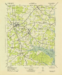
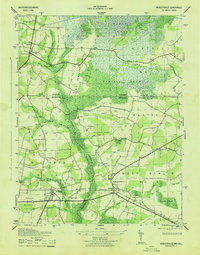
 1915 Seaford1915 Print · USGSCoastal Sussex County and the Maryland borderlands are seen here at a time when river traffic and rail lines were the lifeblood of the region. Researchers can trace the Steamboat Route up to Seaford or locate ancestral sites like Cannons Ferry and Cokesbury School.4 unique versions available
 - 1917 Map of Millsboro
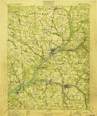
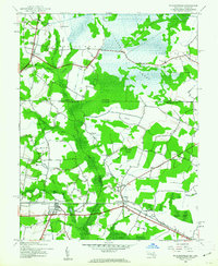
 1917 Millsboro1917 Print · USGSCoastal Sussex County is captured here during the First World War, showing a landscape of rural schoolhouses and railroad sidings centered on Georgetown. Genealogists can trace family connections through numerous landmarks like Mc Colleys, Shortly, and the Westwood Church.2 unique versions available
 - 1918 Map of Cedar Creek
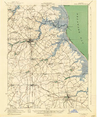
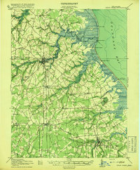 1918 Cedar Creek1918 Print · USGSDelaware's bay coast during the Great War era reveals a landscape of tidal marshes and remote beach landings. Researchers can trace rural Sussex County life through sites like Old Baptist Ch, Mispillion River LH, and the P. B. and W. RR.2 unique versions available
 - 1918 Map of Harrington
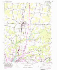
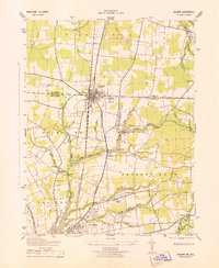
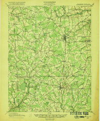 1918 Harrington1918 Print · USGSThe Kent and Sussex County borderlands at the end of the Great War reveal a landscape of busy rail corridors and small schoolhouses. Researchers can trace the legacy of rural education at Union Chapel School or locate family roots near Harrington and Hickman.4 unique versions available
 - 1918 Map of Rehoboth
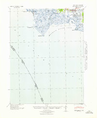
 1918 Rehoboth1918 Print · USGSCoastal Sussex County is seen here at the close of the Great War, when small farming villages still outnumbered beach resorts. Genealogists can trace family roots through numerous rural landmarks like Trinity Church, Eldorado School, and the Grange Hall.8 unique versions available
 - 1918 Map of Cape Henlopen
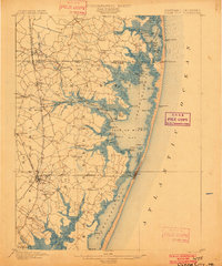
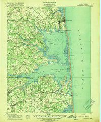
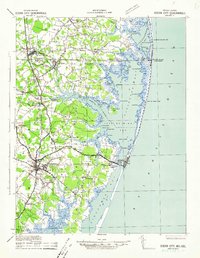
 1918 Cape Henlopen1918 Print · USGSCoastal Sussex County is seen here at a pivotal maritime moment, as the bustling port at Lewes manages the traffic of the Delaware Bay. Researchers can trace early twentieth-century rail lines, the historic Cape Henlopen Light, and local landmarks like West Hill School.2 unique versions available
 - 1919 Map of Cedar Creek
 1919 Cedar Creek1919 Print · USGSSussex County's coastal necks and rail towns are captured here at the end of the Great War. Genealogists can trace family schoolhouses like Cave Neck School and Slaughter Neck School or locate old water-powered sites such as Marshall Mill Pond.
 - 1919 Map of Vineland, 1921 Print
 1919 Vineland1921 Print · USGSCumberland County’s coastal oyster ports and inland industrial centers are captured here during a period of peak maritime activity. Genealogists and historians can trace rail lines like the Central R. R. of New Jersey or locate vanished sites like Whitehall Ldg. and Sheppards Mill.
 - 1937 Map of Cape Henlopen
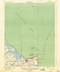 1937 Cape Henlopen1937 Print · USGSThe Delaware coastline near Cape Henlopen comes alive in the early twentieth century, showing a landscape defined by maritime safety and rail transport. Trace the routes of the Pennsylvania RR to settlements like Lewes or locate landmarks such as the West Hill School and Cape Henlopen Light.2 unique versions available
 - 1938 Map of Cedar Creek
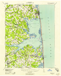
 1938 Cedar Creek1938 Print · USGSCoastal Sussex County in the late 1930s shows a landscape of tidal necks and millponds connected by the P B AND W RR. Genealogists can trace family footprints across dozens of local school sites like Wesleys School and the Old Baptist Church.2 unique versions available
 - 1938 Map of Millsboro, 1945 Print
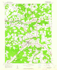
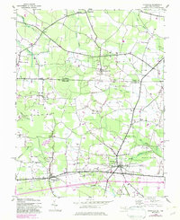
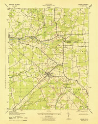
 1938 Millsboro1945 Print · USGSSussex County’s agricultural and rail heartland is captured here between the World Wars, showing Georgetown and Millsboro before modern expansion. Genealogists can trace family roots through numerous named schoolhouses and local junctions like Knowles and Jones Crossroads.
 - 1938 Map of Rehoboth, 1958 Print
 1938 Rehoboth1958 Print · USGSCoastal Sussex County comes alive in the late 1930s, showcasing the early resort development of Rehoboth and Bethany Beach. Genealogists can trace rural family life through a dense network of country schoolhouses like Antioch Sch and Roxana Sch.2 unique versions available
 - 1941 Map of Port Norris
 1941 Port Norris1941 Print · USGSCumberland County's maritime heart is captured here during the early 1940s, as the oyster industry centered on Bivalve and Port Norris reached its mid-century peak. Researchers can trace the Reading Seashore Lines to the coast or locate remote outposts like Fortescue and Matts Landing.
 - 1942 Map of Ocean City
 1942 Ocean City1942 Print · USGSThe Maryland and Delaware coastline at the onset of the 1940s reveals a region of tidal bays and rail-dependent coastal towns. Genealogists and historians can trace family roots in early settlements like Berlin, Sinepuxent, and Bishopville or locate maritime landmarks including Fenwick Island Lighthouse.2 unique versions available
 - 1942 Map of Hebron, 1962 Print
 1942 Hebron1962 Print · USGSThe rural Wicomico County landscape at the start of the 1940s shows a region defined by its creek-fed ponds and rail connections. Researchers can trace the Baltimore and Eastern tracks through Hebron or locate early sites like Spring Hill Airport and Porter Mill Creek.2 unique versions available
 - 1942 Map of Whaleysville, 1962 Print
 1942 Whaleysville1962 Print · USGSThe Maryland and Delaware borderlands were defined by the rail-and-water economy during the early 1940s. Genealogists and local historians can trace the foundations of communities like Whaleysville and Willards, along with rural landmarks like Pulletts Chapel and Newhope Cem.3 unique versions available
 - 1942 Map of Delmar, 1983 Print
 1942 Delmar1983 Print · USGSThe border community of Delmar is shown during its mid-century development as a rail and highway hub on the Delaware-Maryland line. Genealogists and local historians can trace family locations near St George, the Charity church, and the Wicomico River headwaters.
 - 1942 Map of Pittsville, 1983 Print
 1942 Pittsville1983 Print · USGSThe Maryland-Delaware borderlands are captured here in the early 1940s, showing a landscape defined by crossroads communities and extensive drainage works. Researchers can trace family-named sites like Glass Hill or locate the community life centered at Line Church and Pittsville.
 - 1943 Map of Selbyville
 1943 Selbyville1943 Print · USGSDelaware and Maryland borderlands come to life in this mid-century survey of the Selbyville area, showing the region just as wartime mapping efforts reached their peak. Genealogists can trace family footprints through historic centers like Bishopville, Showell, and St Martins Church.2 unique versions available
 - 1943 Map of Delmar
 1943 Delmar1943 Print · USGSThe Maryland-Delaware border region comes alive in this wartime survey of the rail and water networks connecting the two states. Genealogists can trace family locations near the State Game Farm or the rural settlements of Charity and Five Points.
 - 1943 Map of Whaleysville
 1943 Whaleysville1943 Print · USGSThe Maryland-Delaware border region in the early 1940s was a landscape defined by the drainage of the Cypress Swamp and the Pocomoke River. Researchers can locate historic rural landmarks including Pilgrim Church, Pulletts Chapel, and the Newhope Cem.
 - 1943 Map of Hebron
 1943 Hebron1943 Print · USGSHebron and its surrounding rural districts are captured here in the 1940s as wartime infrastructure began to meet traditional Maryland farm life. Genealogists can locate family landmarks like Porter Mill Cr and trace the Baltimore and Eastern rail line through Rockawalking.
Showing maps 1-25 of 128
Top cities of Sussex County
- Seaford historical maps
- Georgetown historical maps
- Laurel historical maps
- Lewes historical maps
- Millsboro historical maps
- Selbyville historical maps
See more
Frequently asked questions
- What are the different types of historical maps available for Sussex County?
- What is the oldest map of Sussex County?
- Where can I purchase historical maps of Sussex County for my home or office?
- Where can I download high-res historical maps of Sussex County?
- Are there historical topographic maps available for Sussex County?
- Is there historical aerial imagery available for Sussex County?
- Where are historical maps of Sussex County sourced from?