1950s Maps of Georgetown, Delaware
Explore 3 historic maps of Georgetown from the 1950s. These maps offer a rare glimpse into what life looked like during the 1950s — showing old roads, neighborhoods, homes, and landmarks that have changed or disappeared over time.
Whether you're researching your family's past, planning a metal detecting trip, or studying how Georgetown's landscape evolved across the 1950s, these high-resolution maps are a powerful tool for exploring the history of this region.
- Focus on a specific era: All maps on this page are from the 1950s, giving you a focused view of this time period.
- See what’s changed: Compare century-old streets, trails, and buildings to today's modern landscape using overlays and satellite layers.
- Research with precision: Use these maps for genealogy, historical research, land use analysis, or educational projects.
- View, download, or print: Maps are fully viewable online in high resolution, and can be downloaded or printed for your own records.
Start exploring Georgetown's history through authentic maps from the 1950s. This is your window into the past.
Georgetown, DE maps
(3)- 1954 Map of Georgetown, 1955 Print
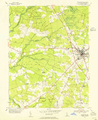 1954 Georgetown1955 Print · USGSGeorgetown and its surrounding rural districts are shown in the mid-fifties, just as highway infrastructure like the Dupont Highway was being modernized. Genealogists can locate community centers like McColley Ch and regional hubs such as Redden Crossroads or Whaleys Corners.3 unique versions available
 - 1955 Map of Harbeson, 1956 Print
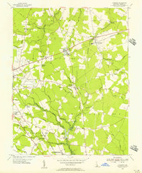 1955 Harbeson1956 Print · USGSCoastal Sussex County in the mid-1950s reveals a landscape of railroad sidings, drainage ditches, and rural crossroads. Genealogists and historians can locate St John Ch, trace the Pennsylvania rail line through Harbeson, and find the Morris Millpond area.4 unique versions available
 - 1957 Map of Salisbury
 1957 Salisbury1957 Print · USGSThe Delmarva Peninsula in the mid-1950s reveals a landscape of coastal defenses and rail-driven commerce. Researchers can trace the Pennsylvania railroad lines or locate historic landmarks like the Fenwick Island Lighthouse and St Martin church.
End of results
Showing maps 1-3 of 3
Top cities near Georgetown
- Milford historical maps
- Seaford historical maps
- Delmar historical maps
- Laurel historical maps
- Harrington historical maps
- Lewes historical maps
See more
Top neighborhoods of Georgetown
- Dunbarton Oaks Apartments historical maps
- Harlemtown historical maps
- Kings Second Addition historical maps
- Murrays Development historical maps
- Swain Acres historical maps
- Greenlea Acres historical maps
See more
Frequently asked questions
- What are the different types of historical maps available for Georgetown?
- What is the oldest map of Georgetown?
- Where can I purchase historical maps of Georgetown for my home or office?
- Where can I download high-res historical maps of Georgetown?
- Are there historical topographic maps available for Georgetown?
- Is there historical aerial imagery available for Georgetown?
- Where are historical maps of Georgetown sourced from?