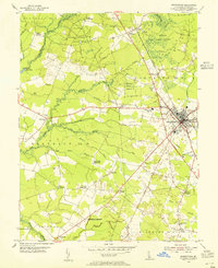
1954 Map of Georgetown
USGS Topo · Published 1955About this map
Georgetown sits at the intersection of local commerce and state administration in central Sussex County during the mid-1950s. The landscape is defined by an intricate network of drainage ditches, such as Mifflin Ditch and Savannah Ditch, which support the agricultural output of the surrounding rural districts. Significant public investment is visible at the University of Delaware Experiment Station and the Redden State Forest, which occupies a large portion of the northern quadrangle. Local community life is anchored by numerous country churches, including Hebron Ch and Cokesbury Ch, while the town itself serves as a transit hub for the Pennsylvania railroad and the Dupont Highway. The presence of the William Jason High Sch and a separate High Sch within the town limits reflects the educational infrastructure of the period.
Find a feature on this map
54 named features on this map. Tap any name to fly to it.
Don’t see what you’re looking for? This feature index may not catch every label — zoom into the map to look around manually.
Map Details
Editions of this 1954 Georgetown Map
3 editions found
Other maps of this area

1915 · Seaford
USGS Topo · 1:62,500

1917 · Millsboro
USGS Topo · 1:62,500

1918 · Cedar Creek
USGS Topo · 1:62,500

1918 · Harrington
USGS Topo · 1:62,500

1919 · Cedar Creek
USGS Topo · 1:62,500

1938 · Cedar Creek
USGS Topo · 1:62,500

1938 · Millsboro
USGS Topo · 1:62,500
1944 · Milton
USGS Topo · 1:24,000

1944 · Cedar Creek
USGS Topo · 1:62,500

1944 · Millsboro
USGS Topo · 1:62,500