1940s Maps of Panama City Beach, Florida
Explore 6 historic maps of Panama City Beach from the 1940s. These maps offer a rare glimpse into what life looked like during the 1940s — showing old roads, neighborhoods, homes, and landmarks that have changed or disappeared over time.
Whether you're researching your family's past, planning a metal detecting trip, or studying how Panama City Beach's landscape evolved across the 1940s, these high-resolution maps are a powerful tool for exploring the history of this region.
- Focus on a specific era: All maps on this page are from the 1940s, giving you a focused view of this time period.
- See what’s changed: Compare century-old streets, trails, and buildings to today's modern landscape using overlays and satellite layers.
- Research with precision: Use these maps for genealogy, historical research, land use analysis, or educational projects.
- View, download, or print: Maps are fully viewable online in high resolution, and can be downloaded or printed for your own records.
Start exploring Panama City Beach's history through authentic maps from the 1940s. This is your window into the past.
Panama City Beach, FL maps
(6)- 1943 Map of Laguna Beach
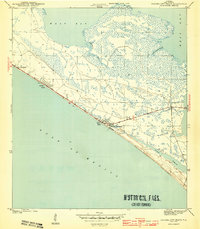
 1943 Laguna Beach1943 Print · USGSThe Florida Panhandle coast appears at the height of the war years, showing a sparsely settled shoreline along the Gulf of Mexico. Local historians can trace the early residential grids and coastal roads of Laguna Beach and Gulf Resort Beach before the post-war development boom.5 unique versions available
 - 1943 Map of Panama City Beach
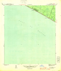
 1943 Panama City Beach1943 Print · USGSPanama City Beach and the surrounding Florida coast are shown during the early 1940s before the era of high-rise development. Researchers can trace the original footprints of Betty Lou Beach and Florida Beach or follow the shoreline of Grand Lagoon.3 unique versions available
 - 1943 Map of Seminole Hills, 1969 Print
 1943 Seminole Hills1969 Print · USGSCoastal Bay County was a landscape of intricate wetlands and new shoreline settlements during the early 1940s. Genealogists and historians can trace the early footprints of Sunnyside and Laird or locate landmarks like County Line Landing and Powell Lake.
 - 1943 Map of West Bay, 1969 Print
 1943 West Bay1969 Print · USGSCoastal Florida in the early 1940s is defined by its winding waterways and undeveloped shoreline. Historians can trace early navigation along the Intracoastal Waterway and locate natural landmarks like Walsonham Point and Burnt Mill Creek.
 - 1944 Map of Seminole Hills
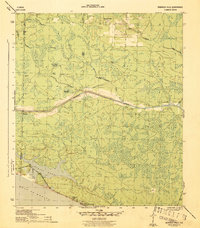 1944 Seminole Hills1944 Print · USGSThe Florida Panhandle shoreline and interior wetlands are shown during the mid-forties, just as coastal communities were establishing themselves. Researchers can trace the early layout of Hollywood Beach and Sunnyside or locate old crossings at County Line Landing.4 unique versions available
 - 1944 Map of West Bay
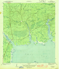 1944 West Bay1944 Print · USGSThe coastal village of West Bay and the surrounding Florida panhandle wetlands are captured in the mid-1940s. Trace the path of the Intracoastal Waterway and the winding reaches of Burnt Mill Creek and Crooked Creek.4 unique versions available
End of results
Showing maps 1-6 of 6
Top cities near Panama City Beach
- Panama City historical maps
- Upper Grand Lagoon historical maps
- Lynn Haven historical maps
- Freeport historical maps
- Beacon Beach historical maps
- Ebro historical maps
See more
Top neighborhoods of Panama City Beach
- Bid-A-Wee historical maps
- Edgewater Gulf Beach historical maps
- Florida Beach historical maps
- Gulf Resort Beach historical maps
- West Panama City Beach historical maps
- Bahama Beach historical maps
See more
Frequently asked questions
- What are the different types of historical maps available for Panama City Beach?
- What is the oldest map of Panama City Beach?
- Where can I purchase historical maps of Panama City Beach for my home or office?
- Where can I download high-res historical maps of Panama City Beach?
- Are there historical topographic maps available for Panama City Beach?
- Is there historical aerial imagery available for Panama City Beach?
- Where are historical maps of Panama City Beach sourced from?