1940s Maps of Panama City, Florida
Explore 6 historic maps of Panama City from the 1940s. These maps offer a rare glimpse into what life looked like during the 1940s — showing old roads, neighborhoods, homes, and landmarks that have changed or disappeared over time.
Whether you're researching your family's past, planning a metal detecting trip, or studying how Panama City's landscape evolved across the 1940s, these high-resolution maps are a powerful tool for exploring the history of this region.
- Focus on a specific era: All maps on this page are from the 1940s, giving you a focused view of this time period.
- See what’s changed: Compare century-old streets, trails, and buildings to today's modern landscape using overlays and satellite layers.
- Research with precision: Use these maps for genealogy, historical research, land use analysis, or educational projects.
- View, download, or print: Maps are fully viewable online in high resolution, and can be downloaded or printed for your own records.
Start exploring Panama City's history through authentic maps from the 1940s. This is your window into the past.
Panama City, FL maps
(6)- 1943 Map of Panama City
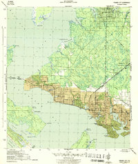 1943 Panama City1943 Print · USGSPanama City and its waterfront neighborhoods are captured here during the wartime mobilization of the early 1940s. Genealogists and local historians can trace the development of Millville, Lynn Haven, and Panama City, along with landmarks like Greenwood Cem and the Municipal Pier.3 unique versions available
 - 1944 Map of Bayhead, 1967 Print
 1944 Bayhead1967 Print · USGSBay County's coastal lowlands and winding bayous are shown here during the mid-1940s, just as these waterfront communities were beginning to develop. Genealogists and historians can trace rail-and-water connections at Bayou George or locate early landings such as Mcallaster Landing.
 - 1945 Map of Youngstown
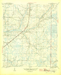 1945 Youngstown1945 Print · USGSThe Florida Panhandle in the mid-forties reveals a landscape shaped by timber, rail, and water. Genealogists and local historians can trace the rail-side communities of Youngstown, Nixon, and Cairo, and locate the historic Bear Creek Ch.3 unique versions available
 - 1945 Map of Bayhead
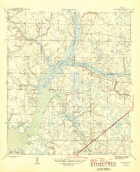 1945 Bayhead1945 Print · USGSThe northern reaches of St Andrews Bay come to life in this mid-1940s survey of coastal Florida. Genealogists and researchers can trace the early layout of Bayou George, the stops along the St Andrews and Atlanta RR, and landings like Mc Allaster Landing.3 unique versions available
 - 1945 Map of North Of Allanton
 1945 North Of Allanton1945 Print · USGSBay County's dense swamp and bayou country is recorded here in the mid-1940s, showing a landscape defined by timber and tide. Researchers can locate the Kent Cem and trace the early route of Allanton Road past the Majette Fire Tower.3 unique versions available
 - 1945 Map of Parker
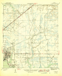 1945 Parker1945 Print · USGSCoastal development along the Florida Panhandle is captured mid-century, showing the growing residential and industrial hubs near the water. Researchers can trace the layout of Springfield, Bay Harbor, and Parker, alongside the path of the Atlanta and St Andrews Bay railroad.2 unique versions available
End of results
Showing maps 1-6 of 6
Top cities near Panama City
- Upper Grand Lagoon historical maps
- Lynn Haven historical maps
- Callaway historical maps
- Panama City Beach historical maps
- Springfield historical maps
- Parker historical maps
See more
Top neighborhoods of Panama City
- Saint Andrew historical maps
- Baker historical maps
- Glenwood historical maps
- Millville historical maps
- Cove historical maps
- Sweet Bay historical maps
See more
Frequently asked questions
- What are the different types of historical maps available for Panama City?
- What is the oldest map of Panama City?
- Where can I purchase historical maps of Panama City for my home or office?
- Where can I download high-res historical maps of Panama City?
- Are there historical topographic maps available for Panama City?
- Is there historical aerial imagery available for Panama City?
- Where are historical maps of Panama City sourced from?