1940s Maps of Jacksonville, Florida
Explore 9 historic maps of Jacksonville from the 1940s. These maps offer a rare glimpse into what life looked like during the 1940s — showing old roads, neighborhoods, homes, and landmarks that have changed or disappeared over time.
Whether you're researching your family's past, planning a metal detecting trip, or studying how Jacksonville's landscape evolved across the 1940s, these high-resolution maps are a powerful tool for exploring the history of this region.
- Focus on a specific era: All maps on this page are from the 1940s, giving you a focused view of this time period.
- See what’s changed: Compare century-old streets, trails, and buildings to today's modern landscape using overlays and satellite layers.
- Research with precision: Use these maps for genealogy, historical research, land use analysis, or educational projects.
- View, download, or print: Maps are fully viewable online in high resolution, and can be downloaded or printed for your own records.
Start exploring Jacksonville's history through authentic maps from the 1940s. This is your window into the past.
Jacksonville, FL maps
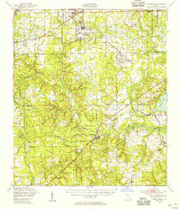
(9)- 1941 Map of Middleburg, 1943 Print
 1941 Middleburg1943 Print · USGSClay County at the dawn of the motorized era reveals a landscape of ferry crossings and rural schoolhouses connected by early roads. Researchers can trace the legacy of the Middleburg area through sites like the Rideout Ferry, Black Creek Church, and several named family schools.
 - 1944 Map of Fernandina
 1944 Fernandina1944 Print · USGSThe Florida-Georgia borderlands come to life in this mid-forties coastal survey of Nassau County and its barrier islands. Genealogists and historians can trace the early footprints of Old Fernandina and Franklintown or locate landmarks like Ft Clinch and the U S Quarantine Sta.
 - 1948 Map of Jacksonville
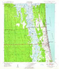
 1948 Jacksonville1948 Print · USGSNortheast Florida and Southeast Georgia's coastal waterways and railroad towns are captured here in the years following the war. Genealogists can trace family connections through river towns like St Marys or identify long-standing military landmarks like Jacksonville NAS.
 - 1948 Map of Jacksonville Beach, 1958 Print
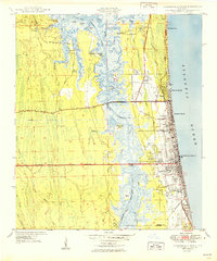
 1948 Jacksonville Beach1958 Print · USGSJacksonville’s coastal suburbs and the marshy barrier islands are shown in detail during the late 1940s. Genealogists and researchers can trace early family sites at Tillotson Cemetery or follow the development of Beach Boulevard.3 unique versions available
 - 1948 Map of Eastport, 1962 Print
 1948 Eastport1962 Print · USGSCoastal Duval County comes to life in the late 1940s as a landscape of tidal marshes and riverfront hamlets along the St Johns River. Researchers can locate vanished landmarks like Quarantine Island or trace local history through the New Berlin Sch and Dunn Creek Cem.
 - 1949 Map of Jacksonville Beach
 1949 Jacksonville Beach1949 Print · USGSCoastal Florida is in a period of rapid post-war expansion as residential neighborhoods push eastward toward the Atlantic. Genealogists and local researchers can locate early landmarks like Donner, Tillotson Cem, and Fletcher High Sch amidst a changing landscape of new roads.2 unique versions available
 - 1949 Map of Fiftone, 1953 Print
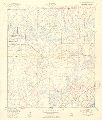
 1949 Fiftone1953 Print · USGSThe rural border of Duval and Clay Counties appears here just after the war, where military expansion met traditional Florida timber and rail lands. Genealogists can locate family landmarks like Mt Zion Ch and Long Branch Ch or trace the early footprint of the Cecil Naval Auxiliary Air Station.2 unique versions available
 - 1949 Map of Jacksonville Heights, 1953 Print
 1949 Jacksonville Heights1953 Print · USGSIn the late 1940s, the rural border of Duval and Clay Counties was being reshaped by naval aviation. Researchers can trace the massive footprints of the Cecil Naval Auxiliary Air Station and Branan Outlying Air Field alongside the Atlantic Coast Line.2 unique versions available
 - 1949 Map of Middleburg, 1955 Print
 1949 Middleburg1955 Print · USGSClay County at mid-century shows a landscape of deep-rooted river settlements and emerging Cold War aviation. Genealogists and historians can trace the foundations of Middleburg and Doctors Inlet, alongside notable sites like Rideout Ferry and Peoria Ch.
End of results
Showing maps 1-9 of 9
Top cities near Jacksonville
Top neighborhoods of Jacksonville
- Maxville historical maps
- Biltmore historical maps
- Hyde Park historical maps
- Grand Park historical maps
- Brentwood historical maps
- Lake Shore historical maps
See more
Frequently asked questions
- What are the different types of historical maps available for Jacksonville?
- What is the oldest map of Jacksonville?
- Where can I purchase historical maps of Jacksonville for my home or office?
- Where can I download high-res historical maps of Jacksonville?
- Are there historical topographic maps available for Jacksonville?
- Is there historical aerial imagery available for Jacksonville?
- Where are historical maps of Jacksonville sourced from?