1970s Maps of Pensacola, Florida
Explore 4 historic maps of Pensacola from the 1970s. These maps offer a rare glimpse into what life looked like during the 1970s — showing old roads, neighborhoods, homes, and landmarks that have changed or disappeared over time.
Whether you're researching your family's past, planning a metal detecting trip, or studying how Pensacola's landscape evolved across the 1970s, these high-resolution maps are a powerful tool for exploring the history of this region.
- Focus on a specific era: All maps on this page are from the 1970s, giving you a focused view of this time period.
- See what’s changed: Compare century-old streets, trails, and buildings to today's modern landscape using overlays and satellite layers.
- Research with precision: Use these maps for genealogy, historical research, land use analysis, or educational projects.
- View, download, or print: Maps are fully viewable online in high resolution, and can be downloaded or printed for your own records.
Start exploring Pensacola's history through authentic maps from the 1970s. This is your window into the past.
Pensacola, FL maps
(4)- 1970 Map of Pensacola, 1972 Print
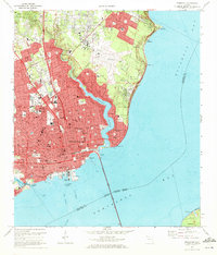 1970 Pensacola1972 Print · USGSPensacola's waterfront and growing suburbs are captured here just as the city's modern footprint was solidifying. Genealogists and historians can trace neighborhood development through numerous local schools and cemeteries like St Johns Cem and Holy Cross Cemetery.3 unique versions available
 - 1970 Map of West Pensacola, 1972 Print
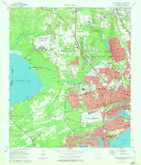 1970 West Pensacola1972 Print · USGSCoastal Florida is shown in the era of naval expansion and suburban growth between Perdido and Pensacola Bays. Genealogists and researchers can trace family landmarks like Spring Hill Ch, old schools such as Myrtle Grove Sch, and the grounds of Saufley Field.2 unique versions available
 - 1978 Map of Pace
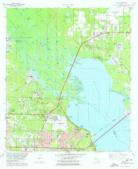 1978 Pace1978 Print · USGSCoastal development and river industry converge near Escambia Bay during the late seventies. Family historians can trace local roots at Whitmire Cem or follow the growth of Pace and the University of West Florida campus.3 unique versions available
 - 1978 Map of Pensacola, 1980 Print
 1978 Pensacola1980 Print · USGSThe Gulf Coast at the end of the 1970s reveals a landscape shaped by maritime industry and a heavy naval presence. Researchers can trace the development of Pensacola alongside quiet coastal hamlets like Magnolia Springs and the historic Fort Pickens State Park.3 unique versions available
End of results
Showing maps 1-4 of 4
Top cities near Pensacola
Top neighborhoods of Pensacola
- Bohemia historical maps
- Gaberonne historical maps
- East Pensacola Heights historical maps
- Sanders Beach historical maps
- Gull Point historical maps
- Cordova Park historical maps
See more
Frequently asked questions
- What are the different types of historical maps available for Pensacola?
- What is the oldest map of Pensacola?
- Where can I purchase historical maps of Pensacola for my home or office?
- Where can I download high-res historical maps of Pensacola?
- Are there historical topographic maps available for Pensacola?
- Is there historical aerial imagery available for Pensacola?
- Where are historical maps of Pensacola sourced from?