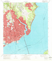
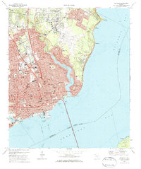
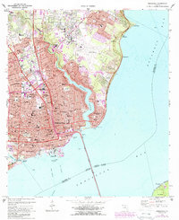
1970 Map of Pensacola
USGS Topo · Published 1972About this map
Pensacola is shown at a period of significant mid-century expansion, centered on the historic waterfront and the complex shoreline of Bayou Texar. The map detail captures the dense urban core around Seville Square and the active maritime infrastructure of the Pensacola Port Authority and Muscogee Wharf. This 1970 field-checked survey documents a city transitioning from its historical maritime roots to a regional educational and transportation hub, evidenced by the large campus of Pensacola Junior College and the sprawl of Pensacola Municipal Airport. The residential character of the era is preserved through numerous neighborhood schools such as Booker T Washington High Sch and Suter Sch. To the south, the Pensacola Gulf Breeze Bridge spans the bay toward Gulf Breeze, illustrating the post-war connectivity that reshaped the Florida Panhandle's coast.
Find a feature on this map
66 named features on this map. Tap any name to fly to it.
Don’t see what you’re looking for? This feature index may not catch every label — zoom into the map to look around manually.
Map Details
Editions of this 1970 Pensacola Map
3 editions found
Other maps of this area

1920 · Milton
USGS Topo · 1:62,500

1921 · Pensacola
USGS Topo · 1:62,500

1921 · Fort Barrancas
USGS Topo · 1:62,500

1921 · Muscogee
USGS Topo · 1:62,500

1941 · Fort Barrancas
USGS Topo · 1:62,500

1941 · Muscogee
USGS Topo · 1:62,500

1941 · Pensacola
USGS Topo · 1:62,500

1941 · Milton
USGS Topo · 1:62,500

1942 · Pensacola
USGS Topo · 1:62,500

1943 · Muscogee
USGS Topo · 1:62,500
Featured Places
- Pensacola, FL
- East Pensacola Heights, Pensacola
- Gull Point, Pensacola
- Sanders Beach, Pensacola
- Brent, FL