Old Maps of Pensacola, Florida for Hiking & Exploration
Hike through history with 38 historic maps of Pensacola. Explore old trails, ghost towns, and forgotten backroads — perfect for outdoor adventurers and local explorers.
- Rediscover forgotten places: Map out old mining camps, roads, and footpaths that no longer exist on modern maps.
- Layer with modern tools: Combine with LiDAR or satellite views to plan hikes through historical terrain.
- Made for exploration: Popular among hikers, overlanders, and local history lovers.
Use these maps to find adventure and explore the hidden past of Pensacola.
Pensacola, FL maps
(38)- 1920 Map of Milton
 1920 Milton1920 Print · USGSSanta Rosa County's timber and rail economy is captured here just after the first World War. Genealogists and historians can trace the lumber industry through the Manu'g. and Land Co. R.R. and old coastal sites like Bagdad, Floridatown, and Roeville Sta.
 - 1921 Map of Pensacola
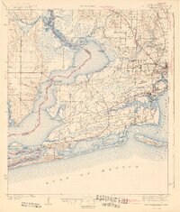
 1921 Pensacola1921 Print · USGSCoastal Florida in the early twentieth century reveals a landscape of maritime industry and military reserves. Map collectors and genealogists can trace the waterfront piers of Muscogee Wharf, the historic U. S. Live Oak Plantation, and early settlements like Bohemia.
 - 1921 Map of Fort Barrancas
 1921 Fort Barrancas1921 Print · USGSThe Florida-Alabama coast at the start of the 1920s reveals a landscape defined by naval history and maritime industry. Researchers can trace the military layout of Ft. Barrancas, locate Pensacola Light, and find vanished streets in Woolsey.
 - 1941 Map of Fort Barrancas
 1941 Fort Barrancas1941 Print · USGSCoastal Florida and Alabama meet at the Perdido River during the early 1940s, showing a landscape of bayous, naval aviation, and growing bayside towns. Genealogists and historians can trace old homesteads near Millview, Fort Barrancas, and schools like Oakfield Sch.3 unique versions available
 - 1941 Map of Pensacola, 1956 Print
 1941 Pensacola1956 Print · USGSPensacola and its surrounding bays are seen here just before the mid-century boom, detailing a landscape defined by naval aviation and maritime rail. Trace the historic city grid, explore the U S Naval Reservation, or locate Oakland Ch and Black Hammock Cem.
 - 1941 Map of Milton, 1956 Print
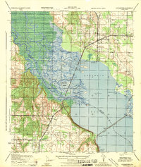
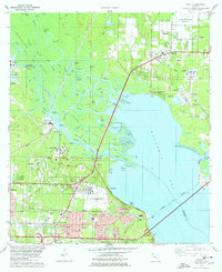
 1941 Milton1956 Print · USGSSanta Rosa County at the start of the 1940s is shown here as a landscape of timber-towns and tidewater rail junctions. Genealogists can trace family names at Allen Cem, Robinson Sch, and the riverside settlements of Bagdad and Floridatown.2 unique versions available
 - 1942 Map of Pensacola
 1942 Pensacola1942 Print · USGSCoastal Florida is captured here in the early years of the war, showing the maritime and rail infrastructure that shaped the Panhandle. Genealogists and historians can trace family locations near Oakland Ch, the Black Hammock Cem, and the busy Muscogee Wharf.2 unique versions available
 - 1943 Map of Fort Barrancas
 1943 Fort Barrancas1943 Print · USGSThe Florida-Alabama borderlands at Perdido Bay come alive in the early 1940s, showing a landscape of coastal swamps and growing Pensacola suburbs. Researchers can trace the grounds of Fort Barrancas, locate Oakfield Sch, or find family roots near Millview and Seminole.2 unique versions available
 - 1943 Map of Milton
 1943 Milton1943 Print · USGSSanta Rosa and Escambia counties are captured here in the early 1940s at the confluence of the Blackwater and Escambia rivers. Researchers can trace the waterfront history of MILTON and Bagdad or locate rural landmarks like Union Valley Ch and Conners Still.2 unique versions available
 - 1944 Map of Floridatown
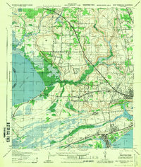
 1944 Floridatown1944 Print · USGSCoastal Santa Rosa County is captured here during the mid-forties, showing the vital river-and-rail hub where the Escambia delta meets the bay. Trace the wartime footprint of Ellyson Field and the historic streets of Floridatown and Pace.
 - 1944 Map of West Pensacola
 1944 West Pensacola1944 Print · USGSWest Pensacola and the surrounding naval aviation grounds are captured here during their mid-century expansion. Trace the growth of Warrington and Myrtle Grove alongside vital wartime infrastructure like Corry Field and the Frisco railroad line.
 - 1944 Map of Pensacola
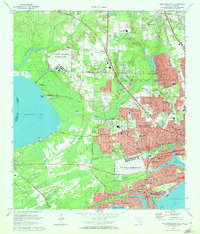
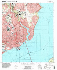
 1944 Pensacola1944 Print · USGSWorld War II era Pensacola reveals a bustling harbor defined by industrial piers and emerging suburbs. Trace the waterfront rail terminals like L & N Railroad Piers and follow the bluffs past Magnolia Bluff to the Bohemia Brick Chimney.
 - 1957 Map of Pensacola, 1967 Print
 1957 Pensacola1967 Print · USGSThe Florida Panhandle and Alabama coast are seen here at the height of the Cold War, showcasing a unique mix of military aviation and emerging beach tourism. Genealogists and local historians can trace legacy sites like Old Corry Field, the lumber town of Bagdad, and the coastal reaches of Santa Rosa Island.3 unique versions available
 - 1959 Map of Pensacola
 1959 Pensacola1959 Print · USGSThe Florida Panhandle and Alabama coast come alive in this late fifties survey of military aviation and maritime life. Genealogists can trace family roots in Bagdad, Loxley, and Milton while mapping the rails of the Louisville and Nashville.
 - 1960 Map of Pensacola
 1960 Pensacola1960 Print · USGSThe Florida Panhandle and Alabama's eastern shore are shown during a period of rapid military and coastal growth. Genealogists and historians can trace the mid-century footprints of Warrington, the Pensacola NAS (Chevalier), and the Blackwater River timber lands.
 - 1970 Map of Pensacola, 1972 Print
 1970 Pensacola1972 Print · USGSPensacola's waterfront and growing suburbs are captured here just as the city's modern footprint was solidifying. Genealogists and historians can trace neighborhood development through numerous local schools and cemeteries like St Johns Cem and Holy Cross Cemetery.3 unique versions available
 - 1970 Map of West Pensacola, 1972 Print
 1970 West Pensacola1972 Print · USGSCoastal Florida is shown in the era of naval expansion and suburban growth between Perdido and Pensacola Bays. Genealogists and researchers can trace family landmarks like Spring Hill Ch, old schools such as Myrtle Grove Sch, and the grounds of Saufley Field.2 unique versions available
 - 1978 Map of Pace
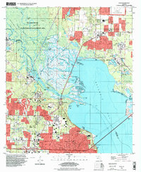
 1978 Pace1978 Print · USGSCoastal development and river industry converge near Escambia Bay during the late seventies. Family historians can trace local roots at Whitmire Cem or follow the growth of Pace and the University of West Florida campus.3 unique versions available
 - 1978 Map of Pensacola, 1980 Print
 1978 Pensacola1980 Print · USGSThe Gulf Coast at the end of the 1970s reveals a landscape shaped by maritime industry and a heavy naval presence. Researchers can trace the development of Pensacola alongside quiet coastal hamlets like Magnolia Springs and the historic Fort Pickens State Park.3 unique versions available
 - 1981 Map of Bay Minette
 1981 Bay Minette1981 Print · USGSThe Alabama-Florida borderlands come to life in the early 1980s as the river delta meets the growing coastal communities. Researchers can trace the Louisville and Nashville rail lines or locate historical points like Twenty-two Mile Bluff and the Blackwater River State Forest.2 unique versions available
 - 1994 Map of Pace, 1999 Print
 1994 Pace1999 Print · USGSThe Escambia River delta and the growing suburbs of Pensacola are captured here in the mid-1990s as the region's industrial and academic footprints expanded. Researchers can trace the layout of the University of West Florida or locate historic sites like Whitmires Cem and Floridatown.
 - 1994 Map of West Pensacola, 1999 Print
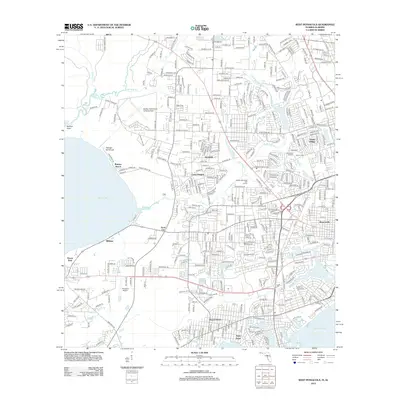
 1994 West Pensacola1999 Print · USGSWestern Escambia County comes into focus in the mid-1990s, showing the deep integration of military bases and suburban development. Genealogists and historians can trace the growth of Myrtle Grove and Warrington near Saufley Field and the shore of Perdido Bay.
 - 1994 Map of Pensacola, 1999 Print
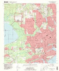
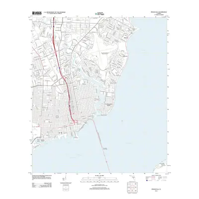
 1994 Pensacola1999 Print · USGSPensacola and its waterfront neighborhoods are shown during the mid-nineties, capturing the city's development from the bay shore to the regional airport. Genealogists and historians can trace local landmarks like Holy Cross Cemetery, the historic Muscogee Wharf, and St Josephs Ch.
 - 2012 Map of Pensacola, 2012 Print
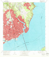
 2012 Pensacola2012 Print · USGSCovers Pensacola, including Goulding, Sanders Beach, and other nearby areas
 - 2012 Map of West Pensacola, 2012 Print
 2012 West Pensacola2012 Print · USGSCovers Pensacola, including Cerny Heights, Sand Cut, and other nearby areas
Showing maps 1-25 of 38
Top cities near Pensacola
Top neighborhoods of Pensacola
- Bohemia historical maps
- Gaberonne historical maps
- East Pensacola Heights historical maps
- Sanders Beach historical maps
- Gull Point historical maps
- Cordova Park historical maps
See more
Frequently asked questions
- What are the different types of historical maps available for Pensacola?
- What is the oldest map of Pensacola?
- Where can I purchase historical maps of Pensacola for my home or office?
- Where can I download high-res historical maps of Pensacola?
- Are there historical topographic maps available for Pensacola?
- Is there historical aerial imagery available for Pensacola?
- Where are historical maps of Pensacola sourced from?