
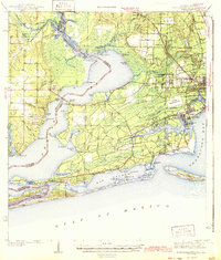
1943 Map of Fort Barrancas
USGS Topo · Published 1943About this map
Fort Barrancas stands as a primary landmark in this coastal survey conducted just before the mid-century, overlooking the waters where Pensacola Bay meets Big Lagoon. The map details the intricate shoreline of Perdido Bay and the winding course of the Perdido River, which serves as the boundary between Baldwin and Escambia counties. The landscape is a complex network of coastal wetlands, including Juniper Swamp and Garcon Swamp, interspersed with emerging residential areas like Warrington, West Pensacola, and Myrtle Grove.
Find a feature on this map
88 named features on this map. Tap any name to fly to it.
Don’t see what you’re looking for? This feature index may not catch every label — zoom into the map to look around manually.
Map Details
Editions of this 1943 Fort Barrancas Map
2 editions found
Other maps of this area

1920 · Milton
USGS Topo · 1:62,500

1920 · Robertsdale
USGS Topo · 1:62,500

1921 · Bon Secour
USGS Topo · 1:62,500

1921 · Pensacola
USGS Topo · 1:62,500

1921 · Fort Barrancas
USGS Topo · 1:62,500

1921 · Muscogee
USGS Topo · 1:62,500

1941 · Fort Barrancas
USGS Topo · 1:62,500

1941 · Muscogee
USGS Topo · 1:62,500

1941 · Robertsdale
USGS Topo · 1:62,500

1941 · Pensacola
USGS Topo · 1:62,500