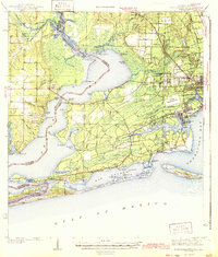
1943 Map of Fort Barrancas
USGS Topo · Published 1943About this map
Fort Barrancas stands as the strategic anchor of this coastal landscape, overlooking the entrance to the bay during the early 1940s. The region is defined by the winding course of the Perdido River and the expansive Perdido Bay, which serves as the natural boundary between Baldwin and Escambia Counties. The map reveals a mix of established military presence and emerging residential pockets, with communities like Warrington, Myrtle Grove, and West Pensacola showing the beginnings of suburban expansion near the coastal waters.
Find a feature on this map
90 named features on this map. Tap any name to fly to it.
Don’t see what you’re looking for? This feature index may not catch every label — zoom into the map to look around manually.
Map Details
Editions of this 1943 Fort Barrancas Map
2 editions found

Other maps of this area

1920 · Milton
USGS Topo · 1:62,500

1920 · Robertsdale
USGS Topo · 1:62,500

1921 · Bon Secour
USGS Topo · 1:62,500

1921 · Pensacola
USGS Topo · 1:62,500

1921 · Fort Barrancas
USGS Topo · 1:62,500

1921 · Muscogee
USGS Topo · 1:62,500

1941 · Fort Barrancas
USGS Topo · 1:62,500

1941 · Muscogee
USGS Topo · 1:62,500

1941 · Robertsdale
USGS Topo · 1:62,500

1941 · Pensacola
USGS Topo · 1:62,500