Old Maps of Jefferson County, Florida for Metal Detecting
Plan your next treasure hunt with 149 historic maps of Jefferson County. Find old homesites, ghost towns, trails, and gathering spots that may be lost to time — perfect for identifying promising metal detecting locations.
- Locate forgotten sites: Uncover places like long-lost settlements, abandoned rail lines, or gathering spots.
- Plan better hunts: Use map overlays combined with LiDAR or satellite views to narrow in on historically rich areas.
- Made for detectorists: Thousands of hobbyists use these maps to discover relics, coins, and hidden history.
Use these historic maps to boost your research and find new opportunities beneath the surface of Jefferson County.
Jefferson County, FL maps
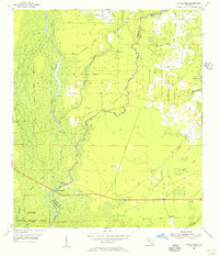
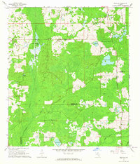
(149)- 1954 Map of Lloyd, 1955 Print
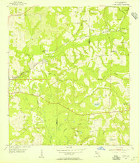 1954 Lloyd1955 Print · USGSIn the mid-1950s, the rural borderlands of Leon and Jefferson counties were a landscape of karst sinks and small rail-side hamlets. Genealogists and historians can trace the foundations of local life through landmarks like St Lukes Ch, Jones Cem, and the historic Seaboard Air Line tracks.2 unique versions available
 - 1954 Map of Greenville, 1956 Print
 1954 Greenville1956 Print · USGSThe Madison and Jefferson County line in the mid-1950s shows a landscape of timber tracts and rail-junction towns. Researchers can trace rural lineages through numerous local landmarks like New Hopewell Ch, Barclay Cem, and the Seaboard Air Line tracks.3 unique versions available
 - 1954 Map of Cody, 1956 Print
 1954 Cody1956 Print · USGSIn the mid-1950s, the boundary between Jefferson, Leon, and Wakulla counties remained a landscape of limestone sinks and rural hamlets. Researchers can trace the early road networks and hydrological landmarks like Hardy Sink, Cody, and Tooles Hammock.2 unique versions available
 - 1954 Map of St. Marks NE, 1956 Print
 1954 St. Marks NE1956 Print · USGSThe Florida Panhandle's karst wilderness is captured here in the mid-fifties, showing the intersection of Wakulla and Jefferson counties. Researchers can trace remote hydrologic features and early refuge boundaries, from Pinhook Sinks to the depths of Gum Swamp.2 unique versions available
 - 1954 Map of Cobb Rocks, 1956 Print
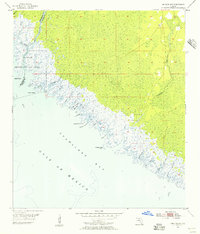
 1954 Cobb Rocks1956 Print · USGSThe Florida Gulf Coast near the Wakulla and Jefferson county line is shown here in the mid-1950s as a wild expanse of tidal marsh and open water. Maritime researchers can trace the winding Pinhook River or locate coastal landmarks like Cobb Rocks and Big Redfish Point.2 unique versions available
 - 1954 Map of Valdosta, 1967 Print
 1954 Valdosta1967 Print · USGSThe South Georgia and North Florida borderlands are captured here in the mid-fifties, showing the deep timber and wetland networks of the coastal plain. Researchers can trace the path of the Atlantic Coast Line through Valdosta or explore the interior of the Okefenokee Swamp.2 unique versions available
 - 1954 Map of Tallahassee, 1967 Print
 1954 Tallahassee1967 Print · USGSThe Florida Panhandle and South Georgia are captured here during a period of mid-century growth and military expansion. Researchers can trace the development of Panama City, the footprint of Tyndall Air Force Base, and the rail lines of the Atlantic Coast Line.4 unique versions available
 - 1955 Map of Lamont, 1956 Print
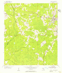
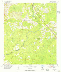
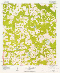
 1955 Lamont1956 Print · USGSJefferson County rural life in the mid-fifties is captured here, centered on the settlements of Aucilla and Lamont. Researchers can locate family landmarks like Turkey Scratch Church, Scruggs Cemetery, and the Seaboard Air Line railroad.3 unique versions available
 - 1955 Map of Snipe Island, 1956 Print
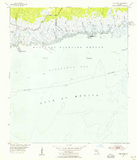
 1955 Snipe Island1956 Print · USGSThe Florida Big Bend coast is captured in the mid-fifties as a wilderness of tidal creeks and river deltas at the Jefferson and Taylor county line. Genealogists and historians can trace the remote Econfina Landing and named coastal landmarks like Snipe Island and Gamble Point.5 unique versions available
 - 1955 Map of Waukeenah, 1956 Print
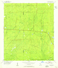
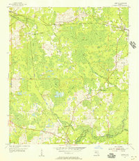
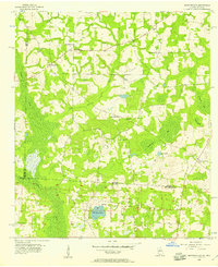
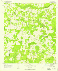
 1955 Waukeenah1956 Print · USGSJefferson County's rural heartland is meticulously documented in the mid-1950s, showing a landscape defined by rail junctions and country parishes. Genealogists and historians can trace the community sites of Bethel Ch, the St Rilla Sch, and the rail crossing at Drifton.3 unique versions available
 - 1955 Map of Nutall Rise, 1956 Print
 1955 Nutall Rise1956 Print · USGSThe Florida Big Bend region at the Jefferson and Taylor county line is a landscape of river confluences and timber history in the mid-1950s. Genealogists and historians can trace the paths of an Old Railroad Grade and locate long-standing settlements like Nutall Rise, Scanlon, and Cabbage Grove.3 unique versions available
 - 1955 Map of Lamont SE, 1956 Print
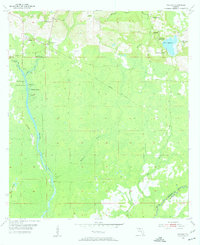
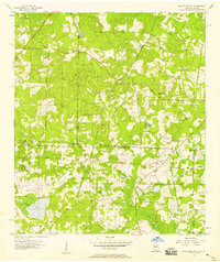
 1955 Lamont SE1956 Print · USGSThe Aucilla River basin in the mid-1950s reveals a rural landscape defined by small river settlements and forest industry. Genealogists can trace family footprints at Walker Cem, Allison Sch, and the remote community of Eridu along the railroad.4 unique versions available
 - 1955 Map of Wacissa, 1956 Print
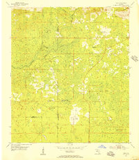
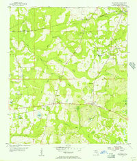
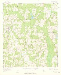
 1955 Wacissa1956 Print · USGSJefferson County was characterized by its spring-fed rivers and rural plantations during the mid-fifties. Researchers can trace family history through sites like Walker Cem and Bethphage Ch or locate the path of the Old Railroad Grade.3 unique versions available
 - 1956 Map of Grooverville, 1957 Print
 1956 Grooverville1957 Print · USGSThe Georgia-Florida borderlands in the mid-fifties reveal a quiet rural landscape of family cemeteries and timbered bays. Researchers can pinpoint the locations of local schools like Grooverville Sch and the grounds of Simmons Hill Ch Cem.2 unique versions available
 - 1956 Map of Monticello NE, 1957 Print
 1956 Monticello NE1957 Print · USGSThe Georgia-Florida borderlands come to life in the mid-fifties, showing a rural landscape defined by the Watson Line and timbered creek bottoms. Genealogists can trace family roots through numerous local landmarks like Mallette Cem, Little Flock Cem, and Olive Ch.3 unique versions available
 - 1956 Map of Metcalf, 1957 Print
 1956 Metcalf1957 Print · USGSCrossing the state line in the mid-fifties, this survey traces the rural settlements and rail siding towns of South Georgia and North Florida. Genealogists can locate family-named landmarks like Hicks Cemetery and the Galilee School.3 unique versions available
 - 1956 Map of Baden, 1958 Print
 1956 Baden1958 Print · USGSThe Georgia-Florida borderlands come to life in the mid-1950s, showing the rural communities and railroad stops along the SOUTHERN line. Researchers can trace family roots at Radford-Denson Cem, Hickory Head Ch, and local schoolhouses like Liberty Sch.2 unique versions available
 - 1957 Map of Miccosukee NE, 1958 Print
 1957 Miccosukee NE1958 Print · USGSThe Georgia-Florida borderlands come to life in the late fifties, showing a rural landscape defined by family cemeteries and country churches. Genealogists can trace roots at Copeland Cem or locate historic meeting places like Trinity Ch and New Hope Ch.2 unique versions available
 - 1958 Map of Valdosta
 1958 Valdosta1958 Print · USGSSouth Georgia and North Florida are captured here in the mid-fifties, showing the vast Okefenokee Swamp and the vital timber and rail corridors connecting the two states. Researchers can locate the footprint of Moody Air Force Base, trace the Live Oak Perry and Gulf railroad, or find early community sites like Bakers Mill and Paradise Church.
 - 1959 Map of Tallahassee
 1959 Tallahassee1959 Print · USGSFlorida's Panhandle and the Big Bend region appear here in the mid-fifties, showing a landscape defined by its great river systems and developing coast. Trace the early layout of Panama City, the expansive Apalachicola National Forest, and the coastal St Marks Lighthouse.
 - 1959 Map of Valdosta
 1959 Valdosta1959 Print · USGSThe Georgia-Florida borderlands in the mid-fifties reveal a landscape of massive blackwater swamps and emerging military aviation hubs. Genealogists and historians can trace rail-stop towns like Fargo and Stockton or explore the interior reaches of the Okefenokee Swamp and Billys Island.
 - 1960 Map of Tallahassee
 1960 Tallahassee1960 Print · USGSThe Florida Panhandle and southern Georgia are captured here in the mid-twentieth century, showing a region defined by its rivers and military installations. Genealogists and historians can trace the growth of Tallahassee or locate coastal landmarks like the St Marks Lighthouse and Tyndall Air Force Base.
 - 1962 Map of Ashville, 1964 Print
 1962 Ashville1964 Print · USGSJefferson and Madison counties remained a pastoral landscape of river swamps and country churches during the early sixties. Genealogists can trace family roots through the many local congregations, including Macedonia Ch, Antioch Ch, and the Old Greenville Ch Bethel Sch.2 unique versions available
 - 1962 Map of Hamburg, 1964 Print
 1962 Hamburg1964 Print · USGSMadison County's wet hammocks and river forks are detailed here in the early sixties. Researchers can trace the Southern Railroad Grade and find historic community centers like Hamburg and the Reaper Cem.3 unique versions available
 - 1963 Map of Lake Miccosukee, 1964 Print
 1963 Lake Miccosukee1964 Print · USGSJefferson County in the early 1960s reveals a landscape of lakeside settlements and evolving rail corridors. Genealogists and local historians can trace family-named sites like Casa Blanco, Montivilla, and rural congregations at Macedonia Ch or Juniors Hill Ch.2 unique versions available
Showing maps 1-25 of 149
Top cities of Jefferson County
Frequently asked questions
- What are the different types of historical maps available for Jefferson County?
- What is the oldest map of Jefferson County?
- Where can I purchase historical maps of Jefferson County for my home or office?
- Where can I download high-res historical maps of Jefferson County?
- Are there historical topographic maps available for Jefferson County?
- Is there historical aerial imagery available for Jefferson County?
- Where are historical maps of Jefferson County sourced from?