1960s Maps of Chiefland, Florida
Explore 2 historic maps of Chiefland from the 1960s. These maps offer a rare glimpse into what life looked like during the 1960s — showing old roads, neighborhoods, homes, and landmarks that have changed or disappeared over time.
Whether you're researching your family's past, planning a metal detecting trip, or studying how Chiefland's landscape evolved across the 1960s, these high-resolution maps are a powerful tool for exploring the history of this region.
- Focus on a specific era: All maps on this page are from the 1960s, giving you a focused view of this time period.
- See what’s changed: Compare century-old streets, trails, and buildings to today's modern landscape using overlays and satellite layers.
- Research with precision: Use these maps for genealogy, historical research, land use analysis, or educational projects.
- View, download, or print: Maps are fully viewable online in high resolution, and can be downloaded or printed for your own records.
Start exploring Chiefland's history through authentic maps from the 1960s. This is your window into the past.
Chiefland, FL maps
(2)- 1968 Map of Trenton, 1971 Print
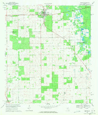 1968 Trenton1971 Print · USGSThe rural interior of Gilchrist County comes into focus during the late sixties, centered on the rail-side settlement of Trenton. Researchers can trace the Seaboard Coast Line tracks and the specific grid of the town center as it stood before modern growth.3 unique versions available
 - 1968 Map of Suwannee River, 1971 Print
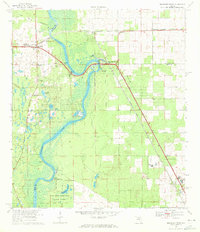 1968 Suwannee River1971 Print · USGSThe Florida river country comes alive in this survey of the tri-county borderlands during the late sixties. Genealogists and local historians can trace the foundations of Old Town and Fanning Springs, or locate rural landmarks like St Christophers Ch and the Old Town Cem.3 unique versions available
End of results
Showing maps 1-2 of 2
Top cities near Chiefland
- Newberry historical maps
- Trenton historical maps
- Bronson historical maps
- Fanning Springs historical maps
- Otter Creek historical maps
Frequently asked questions
- What are the different types of historical maps available for Chiefland?
- What is the oldest map of Chiefland?
- Where can I purchase historical maps of Chiefland for my home or office?
- Where can I download high-res historical maps of Chiefland?
- Are there historical topographic maps available for Chiefland?
- Is there historical aerial imagery available for Chiefland?
- Where are historical maps of Chiefland sourced from?