1950s Maps of Monroe County, Florida
Explore 6 historic maps of Monroe County from the 1950s. These maps offer a rare glimpse into what life looked like during the 1950s — showing old roads, neighborhoods, homes, and landmarks that have changed or disappeared over time.
Whether you're researching your family's past, planning a metal detecting trip, or studying how Monroe County's landscape evolved across the 1950s, these high-resolution maps are a powerful tool for exploring the history of this region.
- Focus on a specific era: All maps on this page are from the 1950s, giving you a focused view of this time period.
- See what’s changed: Compare century-old streets, trails, and buildings to today's modern landscape using overlays and satellite layers.
- Research with precision: Use these maps for genealogy, historical research, land use analysis, or educational projects.
- View, download, or print: Maps are fully viewable online in high resolution, and can be downloaded or printed for your own records.
Start exploring Monroe County's history through authentic maps from the 1950s. This is your window into the past.
Monroe County, FL maps
(6)- 1950 Map of Glades
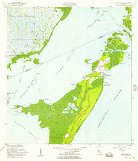
 1950 Glades1950 Print · USGSThe Florida coast at mid-century reveals a landscape defined by the intersection of marsh and sea. Researchers can trace the path of the Old Dixie Highway and locate coastal landmarks like Narrow Point and Manatee Bay.
 - 1956 Map of Card Sound, 1957 Print
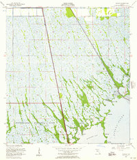
 1956 Card Sound1957 Print · USGSMonroe County and the northern tip of Key Largo are captured here in the mid-fifties, showing the early infrastructure of the Upper Keys. Researchers can trace the development of the Ocean Reef Club, the Grayvik settlement, and the remote Landing Field among the mangroves.5 unique versions available
 - 1956 Map of Pacific Reef, 1957 Print
 1956 Pacific Reef1957 Print · USGSThe northern Florida Keys in the mid-fifties reveal a world of coral heads and shallow channels where Dade and Monroe counties meet. Trace the hazardous coastal navigation routes past the Pacific Reef Lighthouse, Turtle Reef, and Old Rhodes Point.2 unique versions available
 - 1956 Map of Glades, 1957 Print
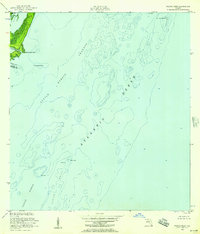
 1956 Glades1957 Print · USGSCoastal Miami-Dade and Monroe Counties are captured in the mid-1950s as a landscape of vast wetlands and developing transit corridors. Researchers can trace the path of the Old Dixie Highway and locate local landmarks like the Quarry and Main Key.4 unique versions available
 - 1956 Map of Miami, 1963 Print
 1956 Miami1963 Print · USGSSouthern Florida experiences post-war expansion in the 1950s, even as the wilderness remains dominant across the southern peninsula. Genealogists and historians can trace suburban growth in Opa-locka and Perrine or locate remote sites like the Tamiami Ranger Station.5 unique versions available
 - 1958 Map of Miami
 1958 Miami1958 Print · USGSSoutheast Florida in the late fifties reveals a coastal boom held in balance with the wild sawgrass and mangroves of Everglades National Park. Trace the paths of the Florida East Coast RR through Homestead or locate the U S Marine Corps Air Station during the height of the Cold War.
End of results
Showing maps 1-6 of 6
Top cities of Monroe County
- Key West historical maps
- Key Largo historical maps
- Marathon historical maps
- Islamorada historical maps
- Big Pine Key historical maps
- Key Colony Beach historical maps
See more
Frequently asked questions
- What are the different types of historical maps available for Monroe County?
- What is the oldest map of Monroe County?
- Where can I purchase historical maps of Monroe County for my home or office?
- Where can I download high-res historical maps of Monroe County?
- Are there historical topographic maps available for Monroe County?
- Is there historical aerial imagery available for Monroe County?
- Where are historical maps of Monroe County sourced from?