1960s Maps of Monroe County, Florida
Explore 3 historic maps of Monroe County from the 1960s. These maps offer a rare glimpse into what life looked like during the 1960s — showing old roads, neighborhoods, homes, and landmarks that have changed or disappeared over time.
Whether you're researching your family's past, planning a metal detecting trip, or studying how Monroe County's landscape evolved across the 1960s, these high-resolution maps are a powerful tool for exploring the history of this region.
- Focus on a specific era: All maps on this page are from the 1960s, giving you a focused view of this time period.
- See what’s changed: Compare century-old streets, trails, and buildings to today's modern landscape using overlays and satellite layers.
- Research with precision: Use these maps for genealogy, historical research, land use analysis, or educational projects.
- View, download, or print: Maps are fully viewable online in high resolution, and can be downloaded or printed for your own records.
Start exploring Monroe County's history through authentic maps from the 1960s. This is your window into the past.
Monroe County, FL maps
(3)- 1962 Map of Key West
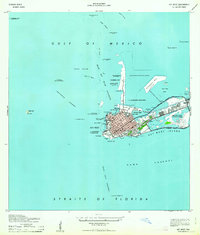 1962 Key West1962 Print · USGSKey West at the start of the sixties reveals a unique landscape where military readiness and island life converged. Genealogists and historians can trace the evolution of Key West Island through landmarks like Fort Taylor, Meacham Field, and Stock I.
 - 1963 Map of Cottrell Key
 1963 Cottrell Key1963 Print · USGSThe remote Florida Keys west of Key West are captured in the mid-twentieth century as a network of isolated islands and navigational towers. Maritime historians can trace coastal features across Boca Grande Key, Woman Key, and the historic NW Passage Bn (Old Tower).
 - 1968 Map of Saddlebunch Keys
 1968 Saddlebunch Keys1968 Print · USGSThe Florida Keys at the close of the 1940s reveal a landscape defined by maritime navigation and isolated island outposts. Maritime researchers can trace essential coastal markers like American Shoal Lighthouse and Ninefoot Shoal Lt or explore the early coastal layout of Sugarloaf Key.
End of results
Showing maps 1-3 of 3
Top cities of Monroe County
- Key West historical maps
- Key Largo historical maps
- Marathon historical maps
- Islamorada historical maps
- Big Pine Key historical maps
- Key Colony Beach historical maps
See more
Frequently asked questions
- What are the different types of historical maps available for Monroe County?
- What is the oldest map of Monroe County?
- Where can I purchase historical maps of Monroe County for my home or office?
- Where can I download high-res historical maps of Monroe County?
- Are there historical topographic maps available for Monroe County?
- Is there historical aerial imagery available for Monroe County?
- Where are historical maps of Monroe County sourced from?