1980s Maps of Monroe County, Florida
Explore 13 historic maps of Monroe County from the 1980s. These maps offer a rare glimpse into what life looked like during the 1980s — showing old roads, neighborhoods, homes, and landmarks that have changed or disappeared over time.
Whether you're researching your family's past, planning a metal detecting trip, or studying how Monroe County's landscape evolved across the 1980s, these high-resolution maps are a powerful tool for exploring the history of this region.
- Focus on a specific era: All maps on this page are from the 1980s, giving you a focused view of this time period.
- See what’s changed: Compare century-old streets, trails, and buildings to today's modern landscape using overlays and satellite layers.
- Research with precision: Use these maps for genealogy, historical research, land use analysis, or educational projects.
- View, download, or print: Maps are fully viewable online in high resolution, and can be downloaded or printed for your own records.
Start exploring Monroe County's history through authentic maps from the 1980s. This is your window into the past.
Monroe County, FL maps
(13)- 1981 Map of Miami, 1982 Print
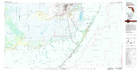
 1981 Miami1982 Print · USGSThe Miami metropolitan corridor and the vast marshlands of the interior are seen here in the early 1980s. Trace the reach of Florida's Turnpike and the Florida East Coast Railway past Opa-locka, Coral Gables, and the Miami International Airport.
 - 1981 Map of Cape Sable, 1982 Print
 1981 Cape Sable1982 Print · USGSThe tip of the Florida peninsula and the coastal Everglades appear here in the early eighties, showcasing a complex wilderness of mangrove channels and tidal bays. Researchers can trace the water systems of Lake Ingraham and Whitewater Bay or locate landmarks like Lonesome Mound.
 - 1982 Map of Everglades City
 1982 Everglades City1982 Print · USGSSouthwest Florida's mangrove coasts and cypress strands appear in detailed transition during the early eighties as conservation boundaries expanded. Researchers can trace remote settlements like Lee Cypress and Copeland or explore the labyrinth of Thousand Islands.
 - 1982 Map of Homestead, 1983 Print
 1982 Homestead1983 Print · USGSThe transition from South Florida's citrus and military hubs to the wilderness of the Everglades is captured here in the early eighties. Researchers can trace the development of Homestead Air Force Base and find remote sites like the Royal Palm Ranger Station and Flamingo.2 unique versions available
 - 1983 Map of Dry Tortugas, 1984 Print
 1983 Dry Tortugas1984 Print · USGSThe remote coral atolls and historic fortifications of the Florida Keys are captured here in the early eighties. Researchers can locate maritime landmarks like the Fort Jefferson masonry works, the Lighthouse on Loggerhead Key, and the sheltered waters of Mooney Harbor.
 - 1983 Map of Islamorada, 1984 Print
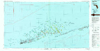
 1983 Islamorada1984 Print · USGSThe Florida Keys at the start of the 1980s show a delicate balance of tourism and preservation along the Overseas Highway. Researchers can trace the development of island communities like Islamorada and Layton, or locate landmarks such as the Long Key Viaduct and Indian Key.
 - 1983 Map of Key West, 1984 Print
 1983 Key West1984 Print · USGSThe Lower Florida Keys are shown in detail in the early 1980s, centered on the military and civilian infrastructure of the archipelago. Trace the path of the Overseas Highway across the Sevenmile Bridge and locate historic sites like Bahia Honda State Park.2 unique versions available
 - 1988 Map of Miami
 1988 Miami1988 Print · USGSSouth Florida in the late eighties shows the sharp edge between the growing urban Atlantic coast and the vast wetlands of Everglades National Park. Researchers can trace the path of the Tamiami Trail and locate coastal settlements like Ochopee or Chokoloskee.
 - 1988 Map of Glades
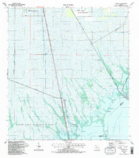 1988 Glades1988 Print · USGSThe southern Florida wetlands meet the coast in the late eighties, showing a landscape defined by conservation and complex drainage. Trace the routes of the South Dixie Highway and Card Sound Road past Narrow Point and Manatee Bay.2 unique versions available
 - 1988 Map of Pacific Reef
 1988 Pacific Reef1988 Print · USGSThe northern Florida Keys and their surrounding coral reefs are mapped here in the late eighties, documenting a critical marine environment. Researchers can trace the maritime boundaries of Biscayne National Park and locate offshore features like the Pacific Reef Lighthouse and Turtle Reef.
 - 1988 Map of Card Sound
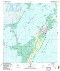 1988 Card Sound1988 Print · USGSUpper Key Largo and the surrounding sounds are captured in the late eighties during a period of refined coastal development. Trace the footprints of private communities like Ocean Reef Club and Grayvik alongside protected lands like Crocodile Lake National Wildlife Refuge.2 unique versions available
 - 1989 Map of Key West, 1990 Print
 1989 Key West1990 Print · USGSThe Florida Keys at the end of the eighties reveal a complex maritime network of coral islands, military outposts, and protected wilderness. Researchers can trace the Overseas Highway across the Sevenmile Bridge and locate features like the U S Naval Air Station Key West and the National Key Deer Refuge.
 - 1989 Map of Dry Tortugas, 1990 Print
 1989 Dry Tortugas1990 Print · USGSThe Florida Straits and the western reaches of the Keys are captured here in the late eighties, documenting the maritime boundaries and reef systems of Monroe County. Researchers can chart the submerged topography near Marquesas Keys or locate specific hazards like Rebecca Shoal and Cosgrove Shoal.
End of results
Showing maps 1-13 of 13
Top cities of Monroe County
- Key West historical maps
- Key Largo historical maps
- Marathon historical maps
- Islamorada historical maps
- Big Pine Key historical maps
- Key Colony Beach historical maps
See more
Frequently asked questions
- What are the different types of historical maps available for Monroe County?
- What is the oldest map of Monroe County?
- Where can I purchase historical maps of Monroe County for my home or office?
- Where can I download high-res historical maps of Monroe County?
- Are there historical topographic maps available for Monroe County?
- Is there historical aerial imagery available for Monroe County?
- Where are historical maps of Monroe County sourced from?