1920s Maps of Monroe County, Florida
Explore 2 historic maps of Monroe County from the 1920s. These maps offer a rare glimpse into what life looked like during the 1920s — showing old roads, neighborhoods, homes, and landmarks that have changed or disappeared over time.
Whether you're researching your family's past, planning a metal detecting trip, or studying how Monroe County's landscape evolved across the 1920s, these high-resolution maps are a powerful tool for exploring the history of this region.
- Focus on a specific era: All maps on this page are from the 1920s, giving you a focused view of this time period.
- See what’s changed: Compare century-old streets, trails, and buildings to today's modern landscape using overlays and satellite layers.
- Research with precision: Use these maps for genealogy, historical research, land use analysis, or educational projects.
- View, download, or print: Maps are fully viewable online in high resolution, and can be downloaded or printed for your own records.
Start exploring Monroe County's history through authentic maps from the 1920s. This is your window into the past.
Monroe County, FL maps
(2)- 1921 Map of Sugar Loaf Key
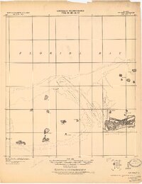
 1921 Sugar Loaf Key1921 Print · USGSThe Lower Florida Keys are captured here in the early twentieth century before modern development transformed the island chain. Maritime researchers and genealogists can trace the original shorelines of Sugarloaf Key, Cudjoe Key, and family-named landmarks like Mallorys Key.2 unique versions available
 - 1921 Map of Key West
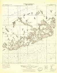
 1921 Key West1921 Print · USGSKey West at the end of the Florida East Coast Railway era is meticulously detailed in this early twentieth-century tactical survey. You can trace the island's coastal defenses at the E. Martello Tower and locate maritime landmarks like the N.W. Bar Light.
End of results
Showing maps 1-2 of 2
Top cities of Monroe County
- Key West historical maps
- Key Largo historical maps
- Marathon historical maps
- Islamorada historical maps
- Big Pine Key historical maps
- Key Colony Beach historical maps
See more
Frequently asked questions
- What are the different types of historical maps available for Monroe County?
- What is the oldest map of Monroe County?
- Where can I purchase historical maps of Monroe County for my home or office?
- Where can I download high-res historical maps of Monroe County?
- Are there historical topographic maps available for Monroe County?
- Is there historical aerial imagery available for Monroe County?
- Where are historical maps of Monroe County sourced from?