1970s Maps of Monroe County, Florida
Explore 66 historic maps of Monroe County from the 1970s. These maps offer a rare glimpse into what life looked like during the 1970s — showing old roads, neighborhoods, homes, and landmarks that have changed or disappeared over time.
Whether you're researching your family's past, planning a metal detecting trip, or studying how Monroe County's landscape evolved across the 1970s, these high-resolution maps are a powerful tool for exploring the history of this region.
- Focus on a specific era: All maps on this page are from the 1970s, giving you a focused view of this time period.
- See what’s changed: Compare century-old streets, trails, and buildings to today's modern landscape using overlays and satellite layers.
- Research with precision: Use these maps for genealogy, historical research, land use analysis, or educational projects.
- View, download, or print: Maps are fully viewable online in high resolution, and can be downloaded or printed for your own records.
Start exploring Monroe County's history through authentic maps from the 1970s. This is your window into the past.
Monroe County, FL maps
(66)- 1971 Map of Key West, 1973 Print
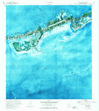
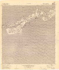
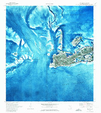 1971 Key West1973 Print · USGSKey West at the beginning of the 1970s reveals a bustling island city integrated with massive naval and aviation facilities. Genealogists and historians can trace the urban grid near City Cemetery, the shoreline at Smathers Beach, and military sites like Fort Taylor.2 unique versions available
 - 1971 Map of Upper Matecumbe Key, 1973 Print
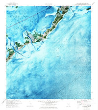
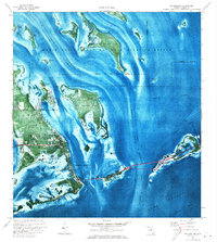
 1971 Upper Matecumbe Key1973 Print · USGSThe Florida Keys are captured here in the early seventies, showing the transition from isolated outposts to a connected coastal corridor. Map collectors can trace the Intracoastal Waterway and locate sites like Islamorada and Lignumvitae Key.3 unique versions available
 - 1971 Map of Tavernier, 1973 Print
 1971 Tavernier1973 Print · USGSThe Florida Keys in the early seventies reveal a detailed look at the maritime and coastal geography around Plantation Key. Genealogists and local historians can trace the early layout of Tavernier, locating landmarks such as the Burton Memorial United Ch and the busy Tavernier Harbor.2 unique versions available
 - 1971 Map of Plantation Key, 1973 Print
 1971 Plantation Key1973 Print · USGSThe upper Florida Keys are captured in detail during the early seventies, showcasing a landscape of coral keys and narrow maritime channels. Genealogists and historians can trace the early footprints of Islamorada, the Coast Guard Sta, and Coral Shores Sch.2 unique versions available
 - 1971 Map of Grassy Key, 1973 Print
 1971 Grassy Key1973 Print · USGSThe Middle Florida Keys are seen in the early seventies during a period of infrastructure growth and coastal mapping. Historians can trace the development of Duck Key, the path of the Long Key Viaduct, and the layout of Grassy Key and Conch Key.2 unique versions available
 - 1971 Map of Boca Chica Key, 1973 Print
 1971 Boca Chica Key1973 Print · USGSThe Lower Florida Keys are shown during a period of significant military and institutional growth in the early seventies. Genealogists and historians can trace the footprint of the U.S. Naval Air Station Key West and community sites like Florida Keys Community College.
 - 1971 Map of Marquesas Keys West, 1973 Print
 1971 Marquesas Keys West1973 Print · USGSThe western reaches of the Florida Keys are captured in the early seventies, showing a pristine marine wilderness. Trace the shifting shoals of the Marquesas Keys and identify remote landmarks like Mooney Harbor and the northern Tower.
 - 1971 Map of Marathon, 1973 Print
 1971 Marathon1973 Print · USGSMarathon and the Middle Keys are shown in the early seventies as this island community entered a period of significant growth. Trace the development of Key Colony Beach, locate the Coast Guard Sta, or study the grounds of the Sombrero Country Club.
 - 1971 Map of Marquesas Keys East, 1973 Print
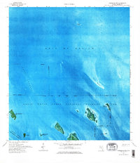
 1971 Marquesas Keys East1973 Print · USGSThe Florida Keys in the early seventies reveal a pristine marine landscape within the Key West National Wildlife Refuge. Researchers can study the shifting shoals of Boca Grande Channel and the shores of Boca Grande Key.
 - 1971 Map of Long Key, 1973 Print
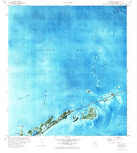
 1971 Long Key1973 Print · USGSThe Florida Keys' middle reach comes alive in this early 1970s survey, highlighting the development around Layton and Long Key State Park. Marine historians and locals can trace the Long Key Viaduct and navigate the flats of Old Dan Bank and Jewfish Hole.
 - 1971 Map of Dry Tortugas, 1973 Print
 1971 Dry Tortugas1973 Print · USGSThe remote islands and reefs of Monroe County appear in detail in the early 1970s, before modern park reclassifications. Trace the massive footprint of Fort Jefferson on Garden Key and locate the Lighthouse on Loggerhead Key.
 - 1971 Map of Lower Matecumbe Key, 1973 Print
 1971 Lower Matecumbe Key1973 Print · USGSLower Matecumbe Key in the early seventies reveals a landscape of growing coastal communities and deep-water channels. Researchers can trace the development of Matecumbe Harbor and locate offshore sites like Indian Key Anchorage and Channel Two.
 - 1971 Map of Crawl Key, 1973 Print
 1971 Crawl Key1973 Print · USGSThe middle Florida Keys appear in the early seventies, caught between the shallow waters of Florida Bay and the open Straits of Florida. Marine historians and researchers can trace the navigational hazards of Coffins Patch or locate landmarks on Crawl Key and Grassy Key.
 - 1972 Map of Marathon
 1972 Marathon1972 Print · USGSThe Middle Keys undergo significant development during the early seventies as new canal-front communities expand across Vaca Key. Researchers can trace the growth of Marathon and Key Colony Beach or locate landmarks like the Coast Guard Sta and High Sch.
 - 1972 Map of Bamboo Key, 1973 Print
 1972 Bamboo Key1973 Print · USGSFlorida Bay and its shallow marine landscape are captured here in the early seventies. Boaters and maritime historians can trace the Intracoastal Waterway and locate the navigational light near the solitary Bamboo Key.
 - 1972 Map of Schooner Bank, 1973 Print
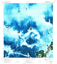
 1972 Schooner Bank1973 Print · USGSFlorida Bay in the early seventies is revealed through this aerial-based survey of the submerged backcountry. Marine historians and local navigators can trace the intricate patterns of Schooner Bank, Ninemile Bank, and Sprigger Bank.2 unique versions available
 - 1972 Map of Cottrell Key, 1973 Print
 1972 Cottrell Key1973 Print · USGSThe Lower Florida Keys and their surrounding protected waters are captured here in the early seventies, spanning from the Gulf to the Straits. Marine historians and researchers can locate remote island landmarks like Cottrell Key, Woman Key, and the Barracouta Keys.
 - 1972 Map of Big Pine Key, 1973 Print
 1972 Big Pine Key1973 Print · USGSThe Lower Keys are captured in the early seventies during a period of infrastructure modernization and environmental preservation. Trace the development of Doctors Arm or locate seasonal sites like Wesumkee Camp and Sawyer Camp along the turquoise waters.
 - 1972 Map of Bay Keys, 1973 Print
 1972 Bay Keys1973 Print · USGSThe lower Florida Keys are revealed in the early seventies through this orthophotomap of the shallow shoals and mangrove islands. Researchers can trace the navigation routes through the Intracoastal Waterway and locate features like West Harbor Key and Cayo Agua.
 - 1972 Map of East Bahia Honda Key, 1973 Print
 1972 East Bahia Honda Key1973 Print · USGSThe lower Florida Keys are captured in the early seventies, showing a maritime landscape defined by shallow shoals and protected waters. Trace the isolated reaches of East Bahia Honda Key and Hardup Key within the Great White Heron National Wildlife Refuge.
 - 1972 Map of Loggerhead Key, 1973 Print
 1972 Loggerhead Key1973 Print · USGSThe lower Florida Keys are captured in the early seventies, detailing the delicate reef structures and navigable channels. Maritime historians can trace the Intracoastal Waterway past Loggerhead Key and the remote outpost of Looe Key.2 unique versions available
 - 1972 Map of East Bahia Honda Key NE, 1973 Print
 1972 East Bahia Honda Key NE1973 Print · USGSFlorida Bay in the early 1970s is revealed through this detailed orthophotomap of the open water and submerged shoals. Researchers can trace the marine boundaries of Everglades National Park and locate navigational aids like the Light near Oxfoot Bank.
 - 1972 Map of Sawyer Key, 1973 Print
 1972 Sawyer Key1973 Print · USGSThe lower Florida Keys are captured in the early seventies, a time when this subtropical archipelago remained largely devoid of roads and trails. Genealogists and historians can trace the protected boundaries of the National Key Deer Refuge and islands like Sawyer Key and Crane Key.2 unique versions available
 - 1972 Map of Horseshoe Keys, 1973 Print
 1972 Horseshoe Keys1973 Print · USGSThe Florida Keys archipelago in the early seventies is revealed through detailed aerial imagery and hydrographic data. Researchers can trace the submerged banks and protected islands of the Great White Heron National Wildlife Refuge and the Horseshoe Keys.2 unique versions available
 - 1972 Map of Content Keys, 1973 Print
 1972 Content Keys1973 Print · USGSFlorida's backcountry waters in the early seventies reveal a landscape of pristine mangrove keys and deep-water channels. Trace the navigable routes through Big Spanish Channel or identify isolated landforms like Content Keys and Annette Key.
Showing maps 1-25 of 66
Top cities of Monroe County
- Key West historical maps
- Key Largo historical maps
- Marathon historical maps
- Islamorada historical maps
- Big Pine Key historical maps
- Key Colony Beach historical maps
See more
Frequently asked questions
- What are the different types of historical maps available for Monroe County?
- What is the oldest map of Monroe County?
- Where can I purchase historical maps of Monroe County for my home or office?
- Where can I download high-res historical maps of Monroe County?
- Are there historical topographic maps available for Monroe County?
- Is there historical aerial imagery available for Monroe County?
- Where are historical maps of Monroe County sourced from?