1970s Maps of Nassau County, Florida
Explore 11 historic maps of Nassau County from the 1970s. These maps offer a rare glimpse into what life looked like during the 1970s — showing old roads, neighborhoods, homes, and landmarks that have changed or disappeared over time.
Whether you're researching your family's past, planning a metal detecting trip, or studying how Nassau County's landscape evolved across the 1970s, these high-resolution maps are a powerful tool for exploring the history of this region.
- Focus on a specific era: All maps on this page are from the 1970s, giving you a focused view of this time period.
- See what’s changed: Compare century-old streets, trails, and buildings to today's modern landscape using overlays and satellite layers.
- Research with precision: Use these maps for genealogy, historical research, land use analysis, or educational projects.
- View, download, or print: Maps are fully viewable online in high resolution, and can be downloaded or printed for your own records.
Start exploring Nassau County's history through authentic maps from the 1970s. This is your window into the past.
Nassau County, FL maps
(11)- 1970 Map of Kings Ferry, 1973 Print
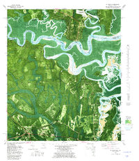
 1970 Kings Ferry1973 Print · USGSThe Georgia-Florida borderlands along the St Marys River are documented here during the early 1970s. Local historians and genealogists can locate several riverfront landings and country churches, including Blood Landing, Kings Ferry, and Mt Olive Ch.3 unique versions available
 - 1970 Map of Hilliard NE, 1973 Print
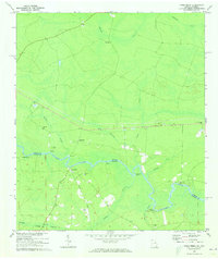
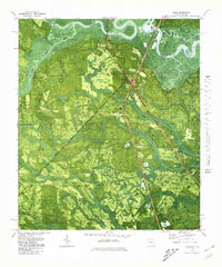
 1970 Hilliard NE1973 Print · USGSNassau County's rural wetlands and small timber-belt settlements are captured here in the early seventies, just as the region’s traditional landscape was being mapped in fine detail. Researchers can locate family landmarks like Braddock Cem, the remote Ephesus Ch, and trace the path of the Seaboard Coast Line railroad.3 unique versions available
 - 1970 Map of Boulogne, 1973 Print
 1970 Boulogne1973 Print · USGSThe Georgia-Florida border comes alive in the early seventies as the St Marys River winds through the wetlands of Camden and Nassau counties. Genealogists and local historians can trace the rail-side growth of Folkston and Boulogne, or locate the Camp Pinckney Ch and Bethune Middle Sch.3 unique versions available
 - 1970 Map of Hilliard, 1973 Print
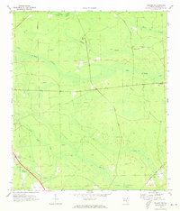
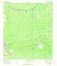
 1970 Hilliard1973 Print · USGSHilliard and north Nassau County are shown in the early 1970s as a community built around the timber and rail industries. Researchers can locate family landmarks like St Theresa Cem, trace the Seaboard Coast Line tracks, and find the remote Andrews settlement.2 unique versions available
 - 1970 Map of Callahan, 1973 Print
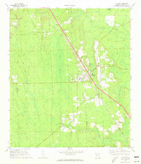
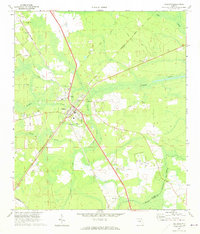 1970 Callahan1973 Print · USGSNassau County's rural rail hubs and creek lands are captured here in the early 1970s. Trace local family history and transit lines near the Callahan junction, Mt Olive Ch, and the Jones Cem.4 unique versions available
 - 1970 Map of Hilliard SW, 1973 Print
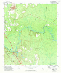
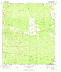 1970 Hilliard SW1973 Print · USGSNassau County's rural interior comes into focus during the early 1970s, showing a landscape shaped by rail transport and wetland drainage. Researchers can trace the junction of the Southern and Seaboard Coast Line railroads near Crawford and Kent.3 unique versions available
 - 1972 Map of Macclenny NE, 1973 Print
 1972 Macclenny NE1973 Print · USGSThe St Marys River corridor along the Georgia-Florida line comes alive in this 1970s survey. Genealogists can trace family names through Pringle Cem and Motes Cem, or locate the rural settlement of Stokesville near the river.2 unique versions available
 - 1972 Map of Macclenny East, 1973 Print
 1972 Macclenny East1973 Print · USGSThe Baker County seat and the Georgia state line meet in the early 1970s along the historic Trail Ridge. Trace the rail corridor of the Seaboard Coast Line through Macclenny and find local landmarks like Brandy Branch Ch and Mattox.
 - 1977 Map of Jacksonville, 1983 Print
 1977 Jacksonville1983 Print · USGSNortheast Florida during the late seventies shows a region defined by its deep-water naval bases and burgeoning riverfront suburbs. You can trace the rail networks of the Seaboard Coast Line, locate the Kingsley Plantation, and study the sprawling grounds of Cecil Field Naval Air Station.
 - 1979 Map of St. Marys, 1980 Print
 1979 St. Marys1980 Print · USGSThe Georgia-Florida border comes alive in the late seventies as the tidal marshlands meet the growing grid of St. Marys. Researchers can trace old family settlements and local landmarks like Oak Grove Cem, Chester, and the Seaboard Coast Line.2 unique versions available
 - 1979 Map of Gross, 1980 Print
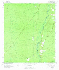
 1979 Gross1980 Print · USGSNassau County, Florida, sits at the Georgia border in the late seventies, where the St Marys River winds through a landscape of timber and swamp. Genealogists can locate small rural centers like Evergreen and Gross, alongside old landmarks like St James Ch and the Seaboard Coast Line railway.
End of results
Showing maps 1-11 of 11
Top cities of Nassau County
Frequently asked questions
- What are the different types of historical maps available for Nassau County?
- What is the oldest map of Nassau County?
- Where can I purchase historical maps of Nassau County for my home or office?
- Where can I download high-res historical maps of Nassau County?
- Are there historical topographic maps available for Nassau County?
- Is there historical aerial imagery available for Nassau County?
- Where are historical maps of Nassau County sourced from?