1990s Maps of Nassau County, Florida
Explore 8 historic maps of Nassau County from the 1990s. These maps offer a rare glimpse into what life looked like during the 1990s — showing old roads, neighborhoods, homes, and landmarks that have changed or disappeared over time.
Whether you're researching your family's past, planning a metal detecting trip, or studying how Nassau County's landscape evolved across the 1990s, these high-resolution maps are a powerful tool for exploring the history of this region.
- Focus on a specific era: All maps on this page are from the 1990s, giving you a focused view of this time period.
- See what’s changed: Compare century-old streets, trails, and buildings to today's modern landscape using overlays and satellite layers.
- Research with precision: Use these maps for genealogy, historical research, land use analysis, or educational projects.
- View, download, or print: Maps are fully viewable online in high resolution, and can be downloaded or printed for your own records.
Start exploring Nassau County's history through authentic maps from the 1990s. This is your window into the past.
Nassau County, FL maps
(8)- 1993 Map of St Marys, 1995 Print
 1993 St Marys1995 Print · USGSThe coastal borderlands of Georgia and Florida come alive in the mid-nineties, centered on the historic riverfront of St Marys. Genealogists and local historians can trace family sites like Oak Grove Cem, Green Pine Cem, and the rural settlement at Chester.2 unique versions available
 - 1993 Map of Gross, 1995 Print
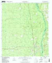
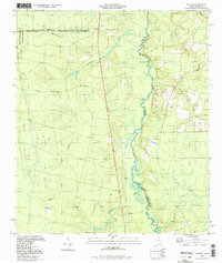
 1993 Gross1995 Print · USGSNassau County's border with Georgia is defined by the winding course of the St Marys River in the early nineties. Genealogists and local historians can trace family roots through landmarks like Wildes Cem, By Faith Ch, and the community of Becker.2 unique versions available
 - 1993 Map of Kingsland, 1995 Print
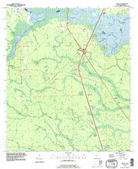
 1993 Kingsland1995 Print · USGSKingsland and the Georgia-Florida border are captured here in the early nineties as modern infrastructure began to reshape the old river landscapes. Genealogists and local historians can trace rural roots through Evergreen Cem, the St Marys Railroad, and the community at Kinlaw.
 - 1994 Map of Folkston
 1994 Folkston1994 Print · USGSNear the Georgia-Florida line in the early 1990s, the riverfront settlement at Traders Hill remained a vital landmark. Genealogists and local historians can trace family roots through sites like Traders Hill Cem, Moody Landing Cem, and the rural Bethel Ch.
 - 1994 Map of Saint George, 1998 Print
 1994 Saint George1998 Print · USGSThe Georgia-Florida borderlands come into focus in the 1990s as the St Marys River meanders through the pine-and-wetland landscape. Genealogists can trace family sites at St George Cemetery and Conner-Green Cem or follow the Old Railroad Grade through St George.
 - 1994 Map of Toledo, 1998 Print
 1994 Toledo1998 Print · USGSThe Georgia-Florida borderlands come into focus in the mid-1990s as the St Marys River meanders past the Toledo settlement. Genealogists and local historians can locate Johnson Cem, the Toledo Lookout Tower, and the eastern gates of the Okefenokee National Wildlife Refuge.
 - 1994 Map of Fernandina Beach, 2002 Print
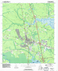
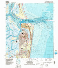 1994 Fernandina Beach2002 Print · USGSAmelia Island and the Georgia-Florida border are captured here in the mid-nineties, showing the intersection of coastal history and modern infrastructure. Genealogists and historians can locate Old Fernandina, Bosque Bello Cem, and schools like Southside Sch.
 - 1998 Map of Baldwin, 2001 Print
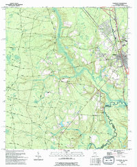
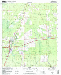 1998 Baldwin2001 Print · USGSWestern Duval County near the turn of the millennium was a landscape defined by strategic military airfields and vital rail junctions. Researchers can trace the layout of Baldwin, find the historic path of Old Plank Road, and locate the facilities at Cecil Field.
End of results
Showing maps 1-8 of 8
Top cities of Nassau County
Frequently asked questions
- What are the different types of historical maps available for Nassau County?
- What is the oldest map of Nassau County?
- Where can I purchase historical maps of Nassau County for my home or office?
- Where can I download high-res historical maps of Nassau County?
- Are there historical topographic maps available for Nassau County?
- Is there historical aerial imagery available for Nassau County?
- Where are historical maps of Nassau County sourced from?