1950s Maps of Nassau County, Florida
Explore 12 historic maps of Nassau County from the 1950s. These maps offer a rare glimpse into what life looked like during the 1950s — showing old roads, neighborhoods, homes, and landmarks that have changed or disappeared over time.
Whether you're researching your family's past, planning a metal detecting trip, or studying how Nassau County's landscape evolved across the 1950s, these high-resolution maps are a powerful tool for exploring the history of this region.
- Focus on a specific era: All maps on this page are from the 1950s, giving you a focused view of this time period.
- See what’s changed: Compare century-old streets, trails, and buildings to today's modern landscape using overlays and satellite layers.
- Research with precision: Use these maps for genealogy, historical research, land use analysis, or educational projects.
- View, download, or print: Maps are fully viewable online in high resolution, and can be downloaded or printed for your own records.
Start exploring Nassau County's history through authentic maps from the 1950s. This is your window into the past.
Nassau County, FL maps
(12)- 1954 Map of Valdosta, 1967 Print
 1954 Valdosta1967 Print · USGSThe South Georgia and North Florida borderlands are captured here in the mid-fifties, showing the deep timber and wetland networks of the coastal plain. Researchers can trace the path of the Atlantic Coast Line through Valdosta or explore the interior of the Okefenokee Swamp.2 unique versions available
 - 1957 Map of Jacksonville, 1967 Print
 1957 Jacksonville1967 Print · USGSCoastal Florida and Georgia meet in the late fifties, showcasing a landscape of naval aviation, deep-water terminals, and barrier island communities. Researchers can trace the mid-century footprints of NAS Jacksonville, find small communities like Franklintown, and locate the historic Fort Clinch State Park.3 unique versions available
 - 1958 Map of Valdosta
 1958 Valdosta1958 Print · USGSSouth Georgia and North Florida are captured here in the mid-fifties, showing the vast Okefenokee Swamp and the vital timber and rail corridors connecting the two states. Researchers can locate the footprint of Moody Air Force Base, trace the Live Oak Perry and Gulf railroad, or find early community sites like Bakers Mill and Paradise Church.
 - 1958 Map of Fernandina Beach, 1959 Print
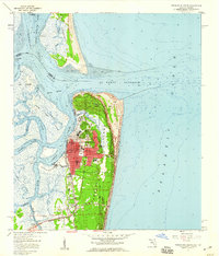 1958 Fernandina Beach1959 Print · USGSCoastal Nassau County comes alive in the late fifties, showcasing the intricate tidal marshes and maritime boundaries of the Florida-Georgia line. Researchers can trace the layout of Fernandina Beach, from St Josephs Academy to the historic Amelia Island Lighthouse.2 unique versions available
 - 1958 Map of Gross, 1959 Print
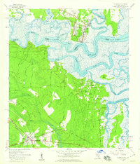
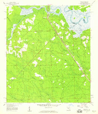 1958 Gross1959 Print · USGSNassau County's river-and-rail corridor is captured in the late 1950s, showing the winding St Marys River border. Genealogists can trace family landmarks like St James Ch in Evergreen or old stops at Gross and Becker.2 unique versions available
 - 1958 Map of Italia, 1959 Print
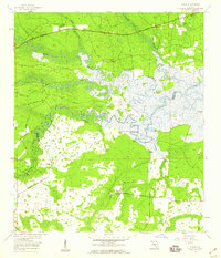 1958 Italia1959 Print · USGSThe Nassau and Duval county line in the late 1950s was a landscape of tide-influenced river bends and expansive wetlands. Researchers can trace historic river access at Joels Landing or locate local landmarks like Harpers Chapel and Ogilvie Cem.4 unique versions available
 - 1958 Map of Hedges, 1959 Print
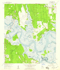 1958 Hedges1959 Print · USGSCoastal Nassau and Duval counties are captured in the late fifties as a landscape of tidal marshes and emerging railside settlements. Genealogists and researchers can trace local family landmarks like Bowles Cem and the landings at Jerry Landing and Henderson Landing.6 unique versions available
 - 1958 Map of St. Marys, 1959 Print
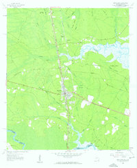
 1958 St. Marys1959 Print · USGSThe Georgia-Florida borderlands come to life in this late fifties portrait of the tidal rivers and wetlands surrounding St Marys. Genealogists and historians can trace family roots through landmarks like Bryant Academy, Oak Grove Cem, and the tracks of the Seaboard Air Line.3 unique versions available
 - 1958 Map of Amelia City, 1959 Print
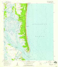 1958 Amelia City1959 Print · USGSCoastal Amelia Island is captured here in the late fifties, showing the barrier island's early settlements and vast marsh systems. Researchers can locate the historic community of American Beach, the site of St Pauls Ch, and the winding Buccaneer Trail.6 unique versions available
 - 1958 Map of Kingsland, 1959 Print
 1958 Kingsland1959 Print · USGSThe coastal Georgia borderlands come alive in the late fifties, centered on the growing rail hub of Kingsland. Genealogists can trace family names through numerous burial sites like Zion Cem and Lawnwood Cem, while explorers follow the St Marys River shoreline.2 unique versions available
 - 1959 Map of Valdosta
 1959 Valdosta1959 Print · USGSThe Georgia-Florida borderlands in the mid-fifties reveal a landscape of massive blackwater swamps and emerging military aviation hubs. Genealogists and historians can trace rail-stop towns like Fargo and Stockton or explore the interior reaches of the Okefenokee Swamp and Billys Island.
 - 1959 Map of Jacksonville
 1959 Jacksonville1959 Print · USGSNortheast Florida and Southeast Georgia are seen here in the late fifties, dominated by the maritime activity of the St Johns River and the Atlantic coast. Researchers can trace the mid-century layout of Jacksonville and identify sprawling military sites like Camp Blanding Military Reservation and Kings Bay Ammunition Terminal.
End of results
Showing maps 1-12 of 12
Top cities of Nassau County
Frequently asked questions
- What are the different types of historical maps available for Nassau County?
- What is the oldest map of Nassau County?
- Where can I purchase historical maps of Nassau County for my home or office?
- Where can I download high-res historical maps of Nassau County?
- Are there historical topographic maps available for Nassau County?
- Is there historical aerial imagery available for Nassau County?
- Where are historical maps of Nassau County sourced from?