1960s Maps of Nassau County, Florida
Explore 7 historic maps of Nassau County from the 1960s. These maps offer a rare glimpse into what life looked like during the 1960s — showing old roads, neighborhoods, homes, and landmarks that have changed or disappeared over time.
Whether you're researching your family's past, planning a metal detecting trip, or studying how Nassau County's landscape evolved across the 1960s, these high-resolution maps are a powerful tool for exploring the history of this region.
- Focus on a specific era: All maps on this page are from the 1960s, giving you a focused view of this time period.
- See what’s changed: Compare century-old streets, trails, and buildings to today's modern landscape using overlays and satellite layers.
- Research with precision: Use these maps for genealogy, historical research, land use analysis, or educational projects.
- View, download, or print: Maps are fully viewable online in high resolution, and can be downloaded or printed for your own records.
Start exploring Nassau County's history through authentic maps from the 1960s. This is your window into the past.
Nassau County, FL maps
(7)- 1960 Map of Jacksonville
 1960 Jacksonville1960 Print · USGSCoastal Florida and Georgia meet in this mid-century portrait of a region shaped by naval power and the winding St Johns River. Researchers can trace the development of military sites like Cecil Field or locate historic rural landmarks such as Jerusalem Ch and Kings Ferry.
 - 1964 Map of Dinsmore, 1965 Print
 1964 Dinsmore1965 Print · USGSThe rural outskirts of Jacksonville appear in the mid-sixties as a network of rail lines and river branches. Genealogists and local historians can trace family locations near Keen Cem, the settlement at Dinsmore, and the Dinsmore Lookout Tower.4 unique versions available
 - 1964 Map of Baldwin, 1965 Print
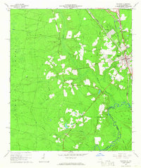
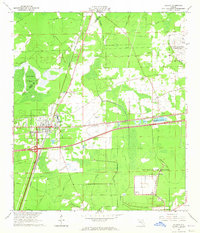 1964 Baldwin1965 Print · USGSWestern Duval County was a major transportation and military corridor in the 1960s, defined by the crossing of two major railroads at Baldwin. Genealogists and historians can trace local landmarks like the Old Plank Road, the Drive-in Theater, and the sprawling US Naval Air Station (Cecil Field).4 unique versions available
 - 1964 Map of Bryceville, 1965 Print
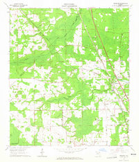
 1964 Bryceville1965 Print · USGSNassau and Duval counties come together in this mid-sixties survey of the Florida pine woods and wetlands. Genealogists and local historians can trace the rail-side hamlets of Verdie, Ingle, and Bryceville, or locate the old Cem and Lookout Tower.3 unique versions available
 - 1966 Map of Toledo, 1967 Print
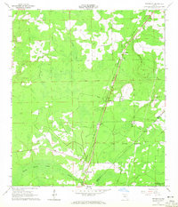
 1966 Toledo1967 Print · USGSThe Georgia-Florida borderlands come into focus in the mid-1960s as the river basin meets the swampy edge of the Okefenokee. Genealogists and historians can trace the community of Toledo, find the Johnson Cem, and follow the Old Railroad Grade through the timber.2 unique versions available
 - 1966 Map of Folkston, 1967 Print
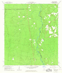
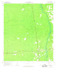
 1966 Folkston1967 Print · USGSIn the mid-1960s, the Folkston area was defined by the intersection of the St Marys River and the Seaboard Coast Line Railroad. Genealogists and researchers can locate several rural landmarks including Traders Hill, Neeley Cem, and Philadelphia Ch.2 unique versions available
 - 1966 Map of St George, 1967 Print
 1966 St George1967 Print · USGSThe borderlands of Charlton County, Georgia, and Florida are captured here in the mid-1960s as the Southern railroad connects the rural interior. Genealogists and historians can trace family locations near St George Cemetery, Conner-Green Cem, and the Boone Creek Ch.3 unique versions available
End of results
Showing maps 1-7 of 7
Top cities of Nassau County
Frequently asked questions
- What are the different types of historical maps available for Nassau County?
- What is the oldest map of Nassau County?
- Where can I purchase historical maps of Nassau County for my home or office?
- Where can I download high-res historical maps of Nassau County?
- Are there historical topographic maps available for Nassau County?
- Is there historical aerial imagery available for Nassau County?
- Where are historical maps of Nassau County sourced from?