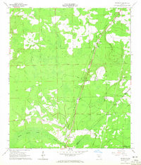
1964 Map of Bryceville
USGS Topo · Published 1965About this map
The Seaboard Air Line railroad corridor dictates the settlement pattern of this mid-century Northeast Florida landscape, connecting the small communities of Dahoma, Verdie, Ingle, and Bryceville. Located along the boundary between Nassau and Duval counties, the area is characterized by dense woodland and extensive wetlands, including Brandy Branch Swamp and the cypress-dotted Crosby Bay. A significant portion of the southeastern quadrant is dedicated to the Cary State Forest, reflecting the region's long-standing timber and conservation interests.
Find a feature on this map
17 named features on this map. Tap any name to fly to it.
Don’t see what you’re looking for? This feature index may not catch every label — zoom into the map to look around manually.
Map Details
Editions of this 1964 Bryceville Map
3 editions found
Other maps of this area

1917 · Cambon
USGS Topo · 1:62,500

1917 · Macclenny
USGS Topo · 1:62,500

1917 · Hilliard
USGS Topo · 1:62,500

1918 · Moniac
USGS Topo · 1:62,500

1918 · Cambon
USGS Topo · 1:62,500

1918 · Macclenny
USGS Topo · 1:62,500

1919 · Hilliard
USGS Topo · 1:62,500

1942 · Moniac
USGS Topo · 1:62,500

1948 · Jacksonville
USGS Topo · 1:250,000

1954 · Valdosta
USGS Topo · 1:250,000