1910s Maps of Saint Johns County, Florida
Explore 6 historic maps of Saint Johns County from the 1910s. These maps offer a rare glimpse into what life looked like during the 1910s — showing old roads, neighborhoods, homes, and landmarks that have changed or disappeared over time.
Whether you're researching your family's past, planning a metal detecting trip, or studying how Saint Johns County's landscape evolved across the 1910s, these high-resolution maps are a powerful tool for exploring the history of this region.
- Focus on a specific era: All maps on this page are from the 1910s, giving you a focused view of this time period.
- See what’s changed: Compare century-old streets, trails, and buildings to today's modern landscape using overlays and satellite layers.
- Research with precision: Use these maps for genealogy, historical research, land use analysis, or educational projects.
- View, download, or print: Maps are fully viewable online in high resolution, and can be downloaded or printed for your own records.
Start exploring Saint Johns County's history through authentic maps from the 1910s. This is your window into the past.
Saint Johns County, FL maps
(6)- 1912 Map of Palatka
 1912 Palatka1912 Print · USGSFlorida's St. Johns River corridor comes alive in the early twentieth century, showing a landscape defined by steamboat routes and citrus-belt railroads. Genealogists and historians can trace old community hubs like Yelvington PO, the Hardin Memorial Church, and the winding Rodman Lumber RR.
 - 1915 Map of Palatka
 1915 Palatka1915 Print · USGSFlorida's riverfront and rail corridors are captured here just after the turn of the century as Palatka thrived as a major transport junction. Researchers can trace family-named landmarks and vanished rural infrastructure like Sutherlands Still, Baptizing Lake, and Seven Pines School.6 unique versions available
 - 1917 Map of Orange Park, 1957 Print
 1917 Orange Park1957 Print · USGSThe St. Johns River corridor comes to life in this early twentieth-century survey of the riverbanks between Jacksonville and Green Cove Springs. Genealogists can trace family footprints through rural sites like Swimming Pen School, Hibernia, and the Durbin P.O. long before suburban sprawl.
 - 1918 Map of Orange Park
 1918 Orange Park1918 Print · USGSThe St. Johns River corridor comes to life in the years following the Great War, showing the transition from riverine commerce to early rail and road networks. Genealogists can locate family landmarks like Neals Dock, Bethel Church, and the Deep Bottom School across three counties.5 unique versions available
 - 1918 Map of Palm Valley
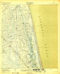 1918 Palm Valley1918 Print · USGSCoastal St. Johns County in the years before heavy development was a wilderness of swamps and vital river landings. Genealogists and researchers can trace early homesteads and rail stops like Sampson, Hilden, and the small community at Palm Valley.4 unique versions available
 - 1918 Map of Mayport
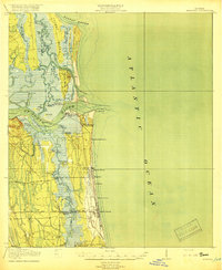 1918 Mayport1918 Print · USGSCoastal Duval County comes alive in the years during the First World War, showing the early shoreline rail network and riverside settlements. Genealogists and historians can trace the foundations of Atlantic Beach and Pablo Beach or locate vanished sites like East Mayport Coquina PO and Howells Mills.4 unique versions available
End of results
Showing maps 1-6 of 6
Top cities of Saint Johns County
- Fruit Cove historical maps
- Ponte Vedra Beach historical maps
- Saint Augustine historical maps
- Saint Augustine Beach historical maps
- Saint Augustine South historical maps
- Saint Augustine Shores historical maps
See more
Frequently asked questions
- What are the different types of historical maps available for Saint Johns County?
- What is the oldest map of Saint Johns County?
- Where can I purchase historical maps of Saint Johns County for my home or office?
- Where can I download high-res historical maps of Saint Johns County?
- Are there historical topographic maps available for Saint Johns County?
- Is there historical aerial imagery available for Saint Johns County?
- Where are historical maps of Saint Johns County sourced from?