Old Maps of Saint Johns County, Florida for Hiking & Exploration
Hike through history with 183 historic maps of Saint Johns County. Explore old trails, ghost towns, and forgotten backroads — perfect for outdoor adventurers and local explorers.
- Rediscover forgotten places: Map out old mining camps, roads, and footpaths that no longer exist on modern maps.
- Layer with modern tools: Combine with LiDAR or satellite views to plan hikes through historical terrain.
- Made for exploration: Popular among hikers, overlanders, and local history lovers.
Use these maps to find adventure and explore the hidden past of Saint Johns County.
Saint Johns County, FL maps
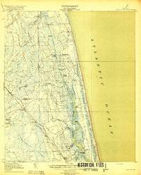
(183)- 1912 Map of Palatka
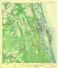
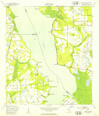
 1912 Palatka1912 Print · USGSFlorida's St. Johns River corridor comes alive in the early twentieth century, showing a landscape defined by steamboat routes and citrus-belt railroads. Genealogists and historians can trace old community hubs like Yelvington PO, the Hardin Memorial Church, and the winding Rodman Lumber RR.
 - 1915 Map of Palatka
 1915 Palatka1915 Print · USGSFlorida's riverfront and rail corridors are captured here just after the turn of the century as Palatka thrived as a major transport junction. Researchers can trace family-named landmarks and vanished rural infrastructure like Sutherlands Still, Baptizing Lake, and Seven Pines School.6 unique versions available
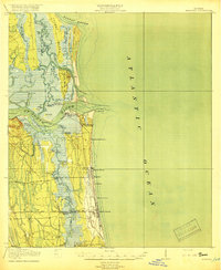
 - 1917 Map of Orange Park, 1957 Print
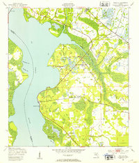
 1917 Orange Park1957 Print · USGSThe St. Johns River corridor comes to life in this early twentieth-century survey of the riverbanks between Jacksonville and Green Cove Springs. Genealogists can trace family footprints through rural sites like Swimming Pen School, Hibernia, and the Durbin P.O. long before suburban sprawl.
 - 1918 Map of Orange Park
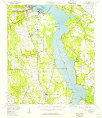
 1918 Orange Park1918 Print · USGSThe St. Johns River corridor comes to life in the years following the Great War, showing the transition from riverine commerce to early rail and road networks. Genealogists can locate family landmarks like Neals Dock, Bethel Church, and the Deep Bottom School across three counties.5 unique versions available
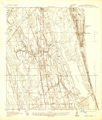
 - 1918 Map of Palm Valley
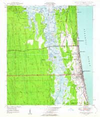
 1918 Palm Valley1918 Print · USGSCoastal St. Johns County in the years before heavy development was a wilderness of swamps and vital river landings. Genealogists and researchers can trace early homesteads and rail stops like Sampson, Hilden, and the small community at Palm Valley.4 unique versions available
 - 1918 Map of Mayport
 1918 Mayport1918 Print · USGSCoastal Duval County comes alive in the years during the First World War, showing the early shoreline rail network and riverside settlements. Genealogists and historians can trace the foundations of Atlantic Beach and Pablo Beach or locate vanished sites like East Mayport Coquina PO and Howells Mills.4 unique versions available
 - 1927 Map of Matanzas
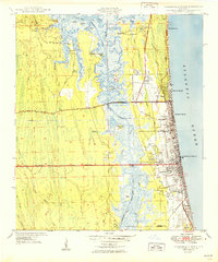
 1927 Matanzas1927 Print · USGSThe Florida coast near the border of St. Johns and Flagler Counties comes to life in this mid-1930s survey. Researchers can trace the early path of State Hy No 140 and locate vanished coastal sites like Summer Haven, Shell, and Hopper.
 - 1937 Map of Bakersville
 1937 Bakersville1937 Print · USGSIn the late 1930s, the St. Johns County backcountry was a mosaic of deep swamps and historic transit routes. Researchers can trace the ancestral locations of the Bakersville Ch and Mill Creek Sch or locate the curious Theatrical Troop Monument.
 - 1937 Map of Elkton
 1937 Elkton1937 Print · USGSSt. Johns County, Florida, is shown in the late thirties during the height of the regional turpentine and rail era. Researchers can trace the layout of Elkton, locate the St Ambrose church, and explore early industrial sites like the Turpentine Camp.
 - 1937 Map of Crescent Beach
 1937 Crescent Beach1937 Print · USGSCoastal St. Johns County in the late thirties shows a landscape of developing beach colonies and inland rail outposts. Researchers can locate the San Lorenzo Cem, trace the grounds of Fort Peyton, or explore industrial sites like the Turpentine Camp.
 - 1937 Map of Dinner Island
 1937 Dinner Island1937 Print · USGSThe Florida interior of the late 1930s is revealed here as a landscape of vast wetlands punctuated by isolated ridges and timber outposts. Researchers can trace the path of the Old Kings Road or locate early stations like Dinner Island Sta. and Neoga Sta.
 - 1937 Map of St. Augustine
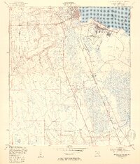
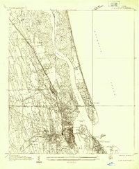 1937 St. Augustine1937 Print · USGSCoastal Florida is captured here in the late thirties, showing the historic streets of St Augustine and its surrounding marshlands. Researchers can trace the layout of Fort Marion, locate Evergreen Cemetery, and find early beach developments at Vilano Beach.
 - 1943 Map of St. Augustine
 1943 St. Augustine1943 Print · USGSSt. Augustine and the Atlantic coast appear here in the early 1940s, showing the historic city alongside its growing beach communities. Researchers can trace the legacy of the Florida East Coast Railway and locate landmarks like Fort Marion Nat Mon and Fort Peyton.2 unique versions available
 - 1943 Map of Dinner Island, 1957 Print
 1943 Dinner Island1957 Print · USGSNortheast Florida in the early 1940s was a landscape defined by isolated interior ridges and vital coastal rail lines. Researchers can trace the original route of the Old Dixie Highway and locate vanished siding stops like Neoga Sta and Byrd.
 - 1943 Map of Matanzas, 1957 Print
 1943 Matanzas1957 Print · USGSThe Florida coast near the St. Johns and Flagler line is captured here during the mid-century, before massive development altered the shoreline. Researchers can trace the path of the Old Kings Road and locate sites like Marineland and Ft Matanzas.
 - 1944 Map of Dinner Island
 1944 Dinner Island1944 Print · USGSMid-century Northeast Florida comes into focus along the coastal marshes and pine islands where the St. Johns and Flagler county lines meet. Trace the historic Dixie Highway and Florida East Coast railroad through Espanola, Spuds, and Neoga Sta.
 - 1944 Map of Matanzas
 1944 Matanzas1944 Print · USGSThe Florida coast near the St. Johns and Flagler line is shown here in the mid-1940s, just as the region began its modern growth. Researchers can trace the historical Old Kings Road and locate early landmarks like Ft Matanzas, Summer Haven, and Marineland.
 - 1947 Map of Bostwick
 1947 Bostwick1947 Print · USGSThe Saint Johns River valley in the late 1940s reveals a landscape defined by its waterways and timber-era rail lines. Researchers can trace historic river access at Clay Landing and Picolata, or follow the Atlantic Coast Line through Bostwick.
 - 1948 Map of Jacksonville
 1948 Jacksonville1948 Print · USGSNortheast Florida and Southeast Georgia's coastal waterways and railroad towns are captured here in the years following the war. Genealogists can trace family connections through river towns like St Marys or identify long-standing military landmarks like Jacksonville NAS.
 - 1948 Map of Jacksonville Beach, 1958 Print
 1948 Jacksonville Beach1958 Print · USGSJacksonville’s coastal suburbs and the marshy barrier islands are shown in detail during the late 1940s. Genealogists and researchers can trace early family sites at Tillotson Cemetery or follow the development of Beach Boulevard.3 unique versions available
 - 1949 Map of Jacksonville Beach
 1949 Jacksonville Beach1949 Print · USGSCoastal Florida is in a period of rapid post-war expansion as residential neighborhoods push eastward toward the Atlantic. Genealogists and local researchers can locate early landmarks like Donner, Tillotson Cem, and Fletcher High Sch amidst a changing landscape of new roads.2 unique versions available
 - 1949 Map of Green Cove Springs, 1953 Print
 1949 Green Cove Springs1953 Print · USGSGreen Cove Springs sits at a post-war crossroads where military installations and river life meet. Genealogists and historians can trace the footprint of the U S Naval Station alongside local landmarks like Hickory Grove Ch and Walkill.5 unique versions available
 - 1949 Map of Riverdale, 1953 Print
 1949 Riverdale1953 Print · USGSThe St. Johns River corridor comes alive in the late 1940s, showing the intersection of three counties and the riverfront communities that thrived there. Genealogists and historians can trace old landings and rail stops like West Tocoi, Federal Point, and the station at Riverdale.4 unique versions available
 - 1949 Map of Picolata, 1953 Print
 1949 Picolata1953 Print · USGSThe eastern banks of the St. Johns River come alive in this post-war survey of St. Johns County. Researchers can trace rural community life through the Picolata Sch, Mt Olive Ch, and small riverfront landings like Magnolia Landing.4 unique versions available
 - 1949 Map of Bostwick, 1955 Print
 1949 Bostwick1955 Print · USGSThe St. Johns River corridor comes to life in the late 1940s, showing a landscape of military installations and quiet river landings. Researchers can trace family roots at Shiloh Ch or Bostwick, and locate vanished river hubs like Picolata and Tocoi.
Showing maps 1-25 of 183
Top cities of Saint Johns County
- Fruit Cove historical maps
- Ponte Vedra Beach historical maps
- Saint Augustine historical maps
- Saint Augustine Beach historical maps
- Saint Augustine South historical maps
- Saint Augustine Shores historical maps
See more
Frequently asked questions
- What are the different types of historical maps available for Saint Johns County?
- What is the oldest map of Saint Johns County?
- Where can I purchase historical maps of Saint Johns County for my home or office?
- Where can I download high-res historical maps of Saint Johns County?
- Are there historical topographic maps available for Saint Johns County?
- Is there historical aerial imagery available for Saint Johns County?
- Where are historical maps of Saint Johns County sourced from?