1970s Maps of Saint Johns County, Florida
Explore 5 historic maps of Saint Johns County from the 1970s. These maps offer a rare glimpse into what life looked like during the 1970s — showing old roads, neighborhoods, homes, and landmarks that have changed or disappeared over time.
Whether you're researching your family's past, planning a metal detecting trip, or studying how Saint Johns County's landscape evolved across the 1970s, these high-resolution maps are a powerful tool for exploring the history of this region.
- Focus on a specific era: All maps on this page are from the 1970s, giving you a focused view of this time period.
- See what’s changed: Compare century-old streets, trails, and buildings to today's modern landscape using overlays and satellite layers.
- Research with precision: Use these maps for genealogy, historical research, land use analysis, or educational projects.
- View, download, or print: Maps are fully viewable online in high resolution, and can be downloaded or printed for your own records.
Start exploring Saint Johns County's history through authentic maps from the 1970s. This is your window into the past.
Saint Johns County, FL maps
(5)- 1970 Map of Elkton, 1973 Print
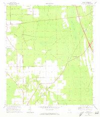 1970 Elkton1973 Print · USGSSt. Johns County is captured in the early seventies, showing a rural landscape of citrus groves and timberlands defined by the Florida East Coast rail line. Genealogists and local historians can trace the foundations of Elkton, Armstrong, and the St Ambrose Ch.3 unique versions available
 - 1970 Map of Bakersville, 1973 Print
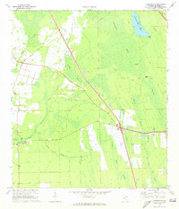 1970 Bakersville1973 Print · USGSSt. Johns County's interior wetlands and early roads are meticulously mapped in the 1970s. Local researchers can locate the Mill Creek Sch, the old Lookout Tower at Bakersville, and the FLORIDA EAST COAST rail line passing by Glimpse of Glory.3 unique versions available
 - 1970 Map of Dinner Island, 1973 Print
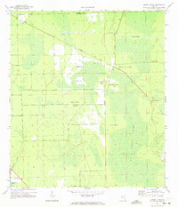 1970 Dinner Island1973 Print · USGSFlorida's interior wetlands are captured here in the 1970s, showing the elevated islands and remote settlements of Flagler County. Genealogists and researchers can trace the diagonal Florida East Coast line through Roy and locate family landmarks like Jack O'Neck Island and Shell Bluff.3 unique versions available
 - 1970 Map of Spuds, 1973 Print
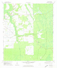 1970 Spuds1973 Print · USGSSt. Johns County agriculture and rail networks come into focus in the early 1970s. Trace the rural crossroads of Spuds and Byrd, find country churches like Mt Olive Ch, and locate old infrastructure along the Florida East Coast railroad.4 unique versions available
 - 1977 Map of Jacksonville, 1983 Print
 1977 Jacksonville1983 Print · USGSNortheast Florida during the late seventies shows a region defined by its deep-water naval bases and burgeoning riverfront suburbs. You can trace the rail networks of the Seaboard Coast Line, locate the Kingsley Plantation, and study the sprawling grounds of Cecil Field Naval Air Station.
End of results
Showing maps 1-5 of 5
Top cities of Saint Johns County
- Fruit Cove historical maps
- Ponte Vedra Beach historical maps
- Saint Augustine historical maps
- Saint Augustine Beach historical maps
- Saint Augustine South historical maps
- Saint Augustine Shores historical maps
See more
Frequently asked questions
- What are the different types of historical maps available for Saint Johns County?
- What is the oldest map of Saint Johns County?
- Where can I purchase historical maps of Saint Johns County for my home or office?
- Where can I download high-res historical maps of Saint Johns County?
- Are there historical topographic maps available for Saint Johns County?
- Is there historical aerial imagery available for Saint Johns County?
- Where are historical maps of Saint Johns County sourced from?