1960s Maps of Volusia County, Florida
Explore 13 historic maps of Volusia County from the 1960s. These maps offer a rare glimpse into what life looked like during the 1960s — showing old roads, neighborhoods, homes, and landmarks that have changed or disappeared over time.
Whether you're researching your family's past, planning a metal detecting trip, or studying how Volusia County's landscape evolved across the 1960s, these high-resolution maps are a powerful tool for exploring the history of this region.
- Focus on a specific era: All maps on this page are from the 1960s, giving you a focused view of this time period.
- See what’s changed: Compare century-old streets, trails, and buildings to today's modern landscape using overlays and satellite layers.
- Research with precision: Use these maps for genealogy, historical research, land use analysis, or educational projects.
- View, download, or print: Maps are fully viewable online in high resolution, and can be downloaded or printed for your own records.
Start exploring Volusia County's history through authentic maps from the 1960s. This is your window into the past.
Volusia County, FL maps
(13)- 1962 Map of Orlando
 1962 Orlando1962 Print · USGSCentral Florida was transformed by aerospace and citrus at the start of the sixties. Genealogists and historians can trace old community footprints from Eau Gallie to Leesburg, alongside landmarks like McCoy AFB and the winding Econlockhatchee River.
 - 1962 Map of Pine Lakes, 1963 Print
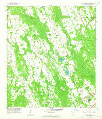
 1962 Pine Lakes1963 Print · USGSThe rural landscape near Cassia and the St. Johns River basin is captured here in the early sixties, showing a region defined by pine woods and citrus groves. Genealogists and local historians can trace the Old Railroad Grade and locate family sites near Cassia Cem or the remote Otter Mound.4 unique versions available
 - 1962 Map of Daytona Beach NW, 1964 Print
 1962 Daytona Beach NW1964 Print · USGSVolusia County's interior wetlands and ridges are captured here during the early sixties, showing a landscape largely defined by water and woods. Genealogists and historians can trace old routes like Jolly Ford Road or locate isolated landmarks such as Harper Ford and Bennett Field.5 unique versions available
 - 1962 Map of Daytona Beach SW, 1964 Print
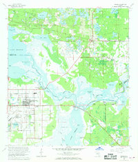
 1962 Daytona Beach SW1964 Print · USGSCoastal Volusia County is captured here in the early sixties as development begins to push inland toward the wetlands. Genealogists and historians can trace the early streets of Daytona Park Estates and find landmarks like Lake Winnemissett and Rattlesnake Island.5 unique versions available
 - 1962 Map of Lake Woodruff, 1964 Print
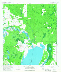
 1962 Lake Woodruff1964 Print · USGSThe Florida wetlands of the early sixties are captured here as the river-and-lake economy shifted toward modern residential growth. Trace old river landings like Bennetts Landing, the settlement at Saint Francis, and the winding path of the St Johns River.3 unique versions available
 - 1964 Map of Daytona Beach
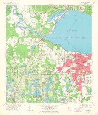
 1964 Daytona Beach1964 Print · USGSCoastal Florida in the mid-1960s shows a fascinating balance between burgeoning beach tourism and the deep interior wilderness of the Ocala National Forest. Researchers can trace the path of the Florida East Coast railway through historic settlements like St. Augustine, Marineland, and Palatka.
 - 1964 Map of De Land, 1965 Print
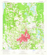 1964 De Land1965 Print · USGSMid-century Volusia County is captured here during a period of steady residential expansion around its historic college town and citrus groves. Genealogists and local historians can trace many family landmarks, including Oakdale Cemetery, Stetson University, and the Atlantic Coast Line rail corridor.4 unique versions available
 - 1964 Map of Orange City, 1965 Print
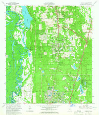 1964 Orange City1965 Print · USGSOrange City and DeBary are shown during a period of significant inland growth in the mid-1960s, framed by the St Johns River and the Atlantic Coast Line. Genealogists can locate family landmarks like Hollywood Cemetery, Mt Berrah Ch, and the old Lansdowne Sch.5 unique versions available
 - 1965 Map of Osteen, 1968 Print
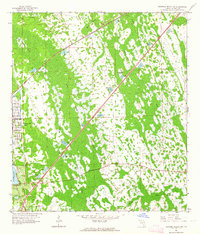
 1965 Osteen1968 Print · USGSThe St. Johns River corridor in the mid-1960s reveals a landscape of transition between the deactivated Sanford Naval Air Station and rural outposts. Genealogists and historians can trace family locations near Osteen, Midway, and the Geneva Cemetery.3 unique versions available
 - 1965 Map of Sanford, 1968 Print
 1965 Sanford1968 Print · USGSSanford and the southern shores of Lake Monroe are captured here in the mid-1960s, a period of established rail infrastructure and military presence. Genealogists and local historians can locate early neighborhoods like Bookertown and Goldsboro Sch, or trace the extensive rail operations at Rand Yard.5 unique versions available
 - 1966 Map of Osceola, 1968 Print
 1966 Osceola1968 Print · USGSThe St. Johns River wetlands meet military history in the mid-1960s as this area of Volusia and Seminole counties transitions. Researchers can trace the footprint of Osceola Field (Abandoned), the ruins at Osceola, and small settlements like Kalamazoo and Farmton.4 unique versions available
 - 1966 Map of Lake Ashby, 1968 Print
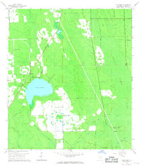 1966 Lake Ashby1968 Print · USGSVolusia County's interior wetlands and settlements are captured here in the mid-1960s as drainage projects shaped the landscape. Genealogists and historians can locate Alamana, trace the Old Railroad Grade, and find landmarks like the Ashby Lookout Tower.3 unique versions available
 - 1966 Map of Lake Helen, 1968 Print
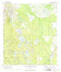 1966 Lake Helen1968 Print · USGSMid-century Volusia County is captured here during the initial expansion of Deltona alongside the established community of Lake Helen. Researchers can trace the legacy of the Old Railroad Grade and find family landmarks like the Osteen Cem or Blake Park.4 unique versions available
End of results
Showing maps 1-13 of 13
Top cities of Volusia County
- Deltona historical maps
- Daytona Beach historical maps
- Ormond Beach historical maps
- DeLand historical maps
- New Smyrna Beach historical maps
- Edgewater historical maps
See more
Frequently asked questions
- What are the different types of historical maps available for Volusia County?
- What is the oldest map of Volusia County?
- Where can I purchase historical maps of Volusia County for my home or office?
- Where can I download high-res historical maps of Volusia County?
- Are there historical topographic maps available for Volusia County?
- Is there historical aerial imagery available for Volusia County?
- Where are historical maps of Volusia County sourced from?