1950s Maps of Wakulla County, Florida
Explore 10 historic maps of Wakulla County from the 1950s. These maps offer a rare glimpse into what life looked like during the 1950s — showing old roads, neighborhoods, homes, and landmarks that have changed or disappeared over time.
Whether you're researching your family's past, planning a metal detecting trip, or studying how Wakulla County's landscape evolved across the 1950s, these high-resolution maps are a powerful tool for exploring the history of this region.
- Focus on a specific era: All maps on this page are from the 1950s, giving you a focused view of this time period.
- See what’s changed: Compare century-old streets, trails, and buildings to today's modern landscape using overlays and satellite layers.
- Research with precision: Use these maps for genealogy, historical research, land use analysis, or educational projects.
- View, download, or print: Maps are fully viewable online in high resolution, and can be downloaded or printed for your own records.
Start exploring Wakulla County's history through authentic maps from the 1950s. This is your window into the past.
Wakulla County, FL maps
(10)- 1954 Map of Sprague Island, 1956 Print
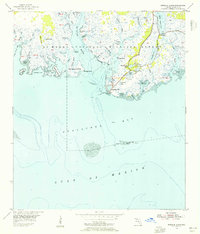 1954 Sprague Island1956 Print · USGSThe Florida coastline at Apalachee Bay is preserved here in the mid-1950s within the St Marks National Wildlife Refuge. Maritime historians and researchers can locate the Lighthouse, the Coast Guard Station Lighthouse, and the Mound Lookout Tower.4 unique versions available
 - 1954 Map of Cody, 1956 Print
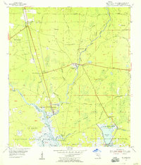
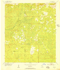 1954 Cody1956 Print · USGSIn the mid-1950s, the boundary between Jefferson, Leon, and Wakulla counties remained a landscape of limestone sinks and rural hamlets. Researchers can trace the early road networks and hydrological landmarks like Hardy Sink, Cody, and Tooles Hammock.2 unique versions available
 - 1954 Map of Woodville, 1956 Print
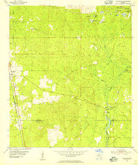 1954 Woodville1956 Print · USGSThe Leon and Wakulla county line area in the mid-1950s reveals a landscape defined by the karst hydrology of the St Marks River. Local historians can trace the paths of the Seaboard Air Line railroad and locate old family burial grounds like Rhodes Cem and Godwin Cem.2 unique versions available
 - 1954 Map of St. Marks NE, 1956 Print
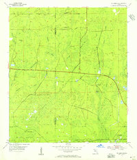 1954 St. Marks NE1956 Print · USGSThe Florida Panhandle's karst wilderness is captured here in the mid-fifties, showing the intersection of Wakulla and Jefferson counties. Researchers can trace remote hydrologic features and early refuge boundaries, from Pinhook Sinks to the depths of Gum Swamp.2 unique versions available
 - 1954 Map of St. Marks, 1956 Print
 1954 St. Marks1956 Print · USGSCoastal Wakulla County comes to life in the mid-fifties, showing the vital confluence of the rivers that shaped Florida's Panhandle history. Genealogists and researchers can trace family landmarks like Magnolia Cem, the ruins at Site of Old Fort St Marks, and the rail stops at Wakulla.2 unique versions available
 - 1954 Map of Cobb Rocks, 1956 Print
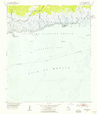 1954 Cobb Rocks1956 Print · USGSThe Florida Gulf Coast near the Wakulla and Jefferson county line is shown here in the mid-1950s as a wild expanse of tidal marsh and open water. Maritime researchers can trace the winding Pinhook River or locate coastal landmarks like Cobb Rocks and Big Redfish Point.2 unique versions available
 - 1954 Map of Tallahassee, 1967 Print
 1954 Tallahassee1967 Print · USGSThe Florida Panhandle and South Georgia are captured here during a period of mid-century growth and military expansion. Researchers can trace the development of Panama City, the footprint of Tyndall Air Force Base, and the rail lines of the Atlantic Coast Line.4 unique versions available
 - 1957 Map of Apalachicola, 1968 Print
 1957 Apalachicola1968 Print · USGSFlorida's Forgotten Coast comes alive in this mid-century portrait of timber, fishing, and military outposts. Researchers can trace the waterfronts of Apalachicola, the grounds of Fort Gadsden, and the early footprint of Mexico Beach before modern development.2 unique versions available
 - 1959 Map of Apalachicola
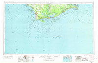
 1959 Apalachicola1959 Print · USGSThe Florida Panhandle's coastline is captured in the late fifties, showcasing the maritime and rail connections between Port St Joe and the oyster-rich waters of Apalachicola. Researchers can trace the legacy of Fort Gadsden or locate historic rail stops like Lanark Station and McIntyre along the coast.
 - 1959 Map of Tallahassee
 1959 Tallahassee1959 Print · USGSFlorida's Panhandle and the Big Bend region appear here in the mid-fifties, showing a landscape defined by its great river systems and developing coast. Trace the early layout of Panama City, the expansive Apalachicola National Forest, and the coastal St Marks Lighthouse.
End of results
Showing maps 1-10 of 10
Top cities of Wakulla County
Frequently asked questions
- What are the different types of historical maps available for Wakulla County?
- What is the oldest map of Wakulla County?
- Where can I purchase historical maps of Wakulla County for my home or office?
- Where can I download high-res historical maps of Wakulla County?
- Are there historical topographic maps available for Wakulla County?
- Is there historical aerial imagery available for Wakulla County?
- Where are historical maps of Wakulla County sourced from?