1950s Maps of Lumpkin County, Georgia
Explore 11 historic maps of Lumpkin County from the 1950s. These maps offer a rare glimpse into what life looked like during the 1950s — showing old roads, neighborhoods, homes, and landmarks that have changed or disappeared over time.
Whether you're researching your family's past, planning a metal detecting trip, or studying how Lumpkin County's landscape evolved across the 1950s, these high-resolution maps are a powerful tool for exploring the history of this region.
- Focus on a specific era: All maps on this page are from the 1950s, giving you a focused view of this time period.
- See what’s changed: Compare century-old streets, trails, and buildings to today's modern landscape using overlays and satellite layers.
- Research with precision: Use these maps for genealogy, historical research, land use analysis, or educational projects.
- View, download, or print: Maps are fully viewable online in high resolution, and can be downloaded or printed for your own records.
Start exploring Lumpkin County's history through authentic maps from the 1950s. This is your window into the past.
Lumpkin County, GA maps
(11)- 1950 Map of Neels Gap, 1952 Print
 1950 Neels Gap1952 Print · USGSNorth Georgia's high country is captured here at mid-century, as the Appalachian Trail wound through the peaks of the Chattahoochee National Forest. Local historians can trace old community landmarks like Mt Zion Ch, Mt Pisgah Sch, and the high waters of Lake Winfield Scott.4 unique versions available
 - 1950 Map of Suches, 1952 Print
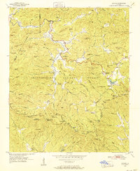 1950 Suches1952 Print · USGSDeep in the Blue Ridge Mountains during the early fifties, this survey captures the rural character of Union and Lumpkin Counties. Genealogists can trace family roots through mountain settlements like Suches and Gaddistown, or locate remote landmarks like Mt Zion Ch and Woody Gap High Sch.4 unique versions available
 - 1950 Map of Campbell Mtn, 1952 Print
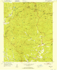
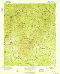
 1950 Campbell Mtn1952 Print · USGSLumpkin County in the early fifties shows a mountain landscape transitioning between its mining heritage and reforestation. Researchers can trace family sites like Davis Chapel Cem, locate the historic Buckhorn Tavern, and identify the Barlow Mine (Inactive).6 unique versions available
 - 1950 Map of Cowrock, 1962 Print
 1950 Cowrock1962 Print · USGSWhite County and the Blue Ridge high country are captured here at mid-century, before modern development reached the mountains. Genealogists and hikers can trace the original path of the Appalachian Trail past Corinth Ch and the remote Blue Ridge Sch.2 unique versions available
 - 1951 Map of Cleveland, 1952 Print
 1951 Cleveland1952 Print · USGSNorth Georgia's mountain foothills come to life in the early fifties, centering on the growing community of Cleveland. Researchers can trace the rural landscape of White County through local landmarks like Mt View Ch, Grace Sch, and the waters of Tesnatee Creek.4 unique versions available
 - 1951 Map of Dahlonega, 1953 Print
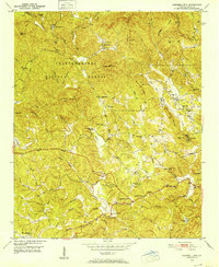
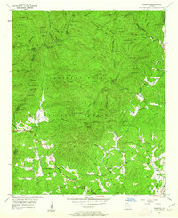
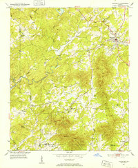
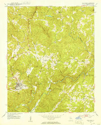 1951 Dahlonega1953 Print · USGSDahlonega and the southern Blue Ridge foothills are captured here in the early fifties, centered on the historic town and its namesake college. Local historians can trace family roots through numerous rural landmarks like Pecks Chapel, Dewey Sch, and the Chestatee River.3 unique versions available
 - 1952 Map of Cowrock
 1952 Cowrock1952 Print · USGSWhite County, Georgia, is shown here in the early 1950s as the high ridges of the Blue Ridge Mountains meet quiet rural settlements. Researchers can trace family roots through the many local landmarks, including Loudsville Church, Lawrence Cemetery, and the Blue Ridge School.2 unique versions available
 - 1954 Map of Greenville, 1965 Print
 1954 Greenville1965 Print · USGSThe Upstate and Northeast Georgia are captured here during a decade of massive transformation as new reservoirs reshaped the Piedmont. Genealogists and hikers can trace the Appalachian Trail over Brasstown Bald or locate old community centers like Demorest, Westminster, and Royston.3 unique versions available
 - 1955 Map of Rome
 1955 Rome1955 Print · USGSThe tri-state borderlands of Georgia, Alabama, and Tennessee appear in the mid-fifties as a landscape of ridge-and-valley industry and river navigation. Genealogists can trace family footprints near Chattanooga, the iron works of Gadsden, and textile towns like Trion or Summerville.
 - 1958 Map of Greenville
 1958 Greenville1958 Print · USGSThe Piedmont and Blue Ridge foothills come alive in this mid-century survey of the Upstate and Northeast Georgia. Trace the regional rail-and-river economy through the Southern Railway corridors and early reservoir developments like Lake Sidney Lanier.
 - 1958 Map of Rome, 1966 Print
 1958 Rome1966 Print · USGSNorthwest Georgia and neighboring Tennessee and Alabama are captured here in the late fifties, showcasing a landscape of high ridges and river valleys. Researchers can trace historic rail lines like the Seaboard Air Line RR and explore the bounds of Cloudland Canyon State Park or Fort Oglethorpe.3 unique versions available
End of results
Showing maps 1-11 of 11
Top cities of Lumpkin County
Frequently asked questions
- What are the different types of historical maps available for Lumpkin County?
- What is the oldest map of Lumpkin County?
- Where can I purchase historical maps of Lumpkin County for my home or office?
- Where can I download high-res historical maps of Lumpkin County?
- Are there historical topographic maps available for Lumpkin County?
- Is there historical aerial imagery available for Lumpkin County?
- Where are historical maps of Lumpkin County sourced from?