1900s (20th Century) Maps of Augusta, Georgia
Explore 56 historic maps of Augusta from the 1900s (20th Century). These maps offer a rare glimpse into what life looked like during the 1900s — showing old roads, neighborhoods, homes, and landmarks that have changed or disappeared over time.
Whether you're researching your family's past, planning a metal detecting trip, or studying how Augusta's landscape evolved across the 1900s, these high-resolution maps are a powerful tool for exploring the history of this region.
- Focus on a specific era: All maps on this page are from the 1900s, giving you a focused view of this time period.
- See what’s changed: Compare century-old streets, trails, and buildings to today's modern landscape using overlays and satellite layers.
- Research with precision: Use these maps for genealogy, historical research, land use analysis, or educational projects.
- View, download, or print: Maps are fully viewable online in high resolution, and can be downloaded or printed for your own records.
Start exploring Augusta's history through authentic maps from the 1900s. This is your window into the past.
Augusta, GA maps
(56)- 1912 Map of Mc Cormick, 1913 Print
 1912 Mc Cormick1913 Print · USGSThe Georgia and South Carolina borderlands come alive in the 1890s, centered on the rail junction at Mc Cormick and the Savannah River. Genealogists can trace family footprints across numerous river crossings like Fury Ferry and through rural centers such as Appling and Sharon Church.
 - 1919 Map of Gough
 1919 Gough1919 Print · USGSEastern Georgia's rural landscape is captured here in the years following the Great War, showing a territory defined by railroad junctions and small community centers. Genealogists can locate family landmarks such as Boggs Academy, Hopeful Church, and the depot at Gough.3 unique versions available
 - 1920 Map of Greens Cut
 1920 Greens Cut1920 Print · USGSBurke County, Georgia, and the Savannah River valley are captured here just after the Great War during a period of peak rural density. Genealogists can locate dozens of country institutions like Daniel Grove Church, Red Hill School, and the Old Church Sta along the Central of Georgia line.3 unique versions available
 - 1920 Map of Clarks Hill
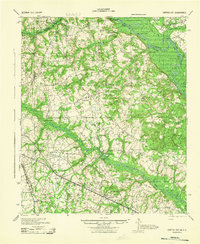
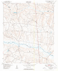
 1920 Clarks Hill1920 Print · USGSThe Savannah River border between South Carolina and Georgia comes alive in this survey, showing the region as it was before the creation of the massive Clarks Hill Lake. Genealogists can trace family landmarks like Gilchrist Ferry, Hosannah Church, and Flat Rock School during the heyday of the Charleston and Western Carolina railroad.
 - 1921 Map of Augusta
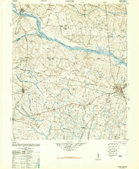
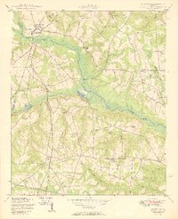
 1921 Augusta1921 Print · USGSThe riverfronts of South Carolina and Georgia met at a busy rail and water crossroads just after the Great War. Genealogists can trace family landmarks like the Downer Institute, Cottage Cem, and early rural schools including Freeborn School and Spiderweb School.5 unique versions available
 - 1921 Map of Clarks Hill
 1921 Clarks Hill1921 Print · USGSThe Savannah River valley in the early twenties was a landscape of ferries and railroad sidings before the creation of modern reservoirs. Genealogists can trace family footprints through dozens of rural landmarks like Hosannah Church, Dorn School, and Gilchrist Ferry.3 unique versions available
 - 1922 Map of Harlem
 1922 Harlem1922 Print · USGSEastern Georgia's rural landscape is captured here in the years following the Great War, showing a territory tied together by the Georgia Railroad. Genealogists can locate family-named landmarks such as Lundie Grove School, Arrington Mill, and Old Union Church.3 unique versions available
 - 1922 Map of Hephzibah
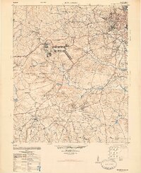
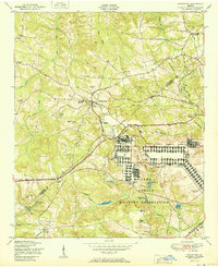
 1922 Hephzibah1922 Print · USGSRichmond County at the end of the First World War shows a landscape defined by military mobilization and deep-rooted rural communities. Local historians can trace the sprawling Camp Hancock cantonment or locate family landmarks like Palmer Academy and Hephzibah.3 unique versions available
 - 1923 Map of Warrenville
 1923 Warrenville1923 Print · USGSAiken and Edgefield counties thrive during the early twentieth-century textile boom, showing a landscape shaped by mill towns and rural academies. Genealogists can trace family roots through numerous landmarks like Bettis Academy, Eureka Station, and Hammond Grove Church.2 unique versions available
 - 1928 Map of Warrenville
 1928 Warrenville1928 Print · USGSAiken and Edgefield counties are shown in the late 1920s as a thriving corridor of textile mills and rural academies. Researchers can trace the development of historic communities and landmarks like Bettis Academy, Vaucluse, and Meeting Grove Ch.3 unique versions available
 - 1941 Map of Clarks Hill, 1957 Print
 1941 Clarks Hill1957 Print · USGSThe Savannah River valley remained a landscape of ferries and river-to-rail commerce just before the era of major dam construction. Genealogists and historians can trace family roots through numerous rural landmarks like Cary Hill Ch, Modoc, and Gilchrist Ferry.2 unique versions available
 - 1942 Map of Clarks Hill
 1942 Clarks Hill1942 Print · USGSThe Savannah River valley along the South Carolina and Georgia border comes alive in this survey from the era of river ferries and local rail. Genealogists can trace family landmarks like Hosannah Church, Dents Ferry, and the Flat Rock School.
 - 1943 Map of Greens Cut
 1943 Greens Cut1943 Print · USGSEastern Georgia during the early 1940s remained a landscape of river landings and rural railroad stops. Genealogists can trace family roots through numerous local landmarks like Old Church Sta, Hatchers Mill, and the settlement of Telfairville.
 - 1943 Map of Augusta East
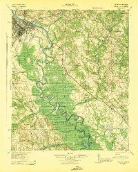
 1943 Augusta East1943 Print · USGSThe Savannah River valley along the Georgia and South Carolina border is shown here in the early 1940s, just before significant regional changes. Genealogists can trace hundreds of rural landmarks, including Ellenton, the Downer Institute, and several mills like Hatchers Mill.
 - 1943 Map of Warrenville
 1943 Warrenville1943 Print · USGSThe industrial corridor of Aiken County is captured here in the early 1940s, highlighting the mill towns along Horse Creek. Genealogists can trace family roots through numerous community landmarks like Bettis Academy, Horn Creek Ch, and the settlement at Vaucluse.
 - 1943 Map of Augusta
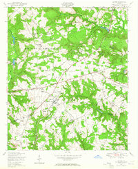
 1943 Augusta1943 Print · USGSThe Savannah River corridor at the Georgia-South Carolina border comes alive in the early 1940s, showing the intricate wetlands and rural communities of Richmond and Aiken Counties. Researchers can locate vanished landmarks like the Downer Institute, the Cottage Cem, and early roads like Tobacco Road.
 - 1948 Map of Hephzibah
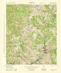
 1948 Hephzibah1948 Print · USGSRichmond County and the Augusta suburbs are seen here during the late 1940s as military footprints like Camp Gordon began to reshape the landscape. Genealogists and local historians can locate dozens of country churches and rural cemeteries, from the Albion-Kaolin Chalk Mine to the Georgia Training School Farm.2 unique versions available
 - 1948 Map of Harlem
 1948 Harlem1948 Print · USGSEastern Georgia in the late forties shows the expansion of the Camp Gordon Military Reservation into a landscape of rural hamlets. Researchers can trace old family sites like Bynum Cemetery and vanished landmarks like Central School (Abandoned).2 unique versions available
 - 1948 Map of Gough
 1948 Gough1948 Print · USGSMid-century Burke County is a landscape of rural schoolhouses and family-named mills as the post-war era began. Genealogists can trace family roots through sites like Boggs Academy, Noah's Ark Church & Cem, and Dyes Crossroads.2 unique versions available
 - 1948 Map of Blythe, 1964 Print
 1948 Blythe1964 Print · USGSBlythe and the surrounding Richmond County countryside appear here just after the war, showing a landscape of small family farms and rural schools. Researchers can trace local genealogy through sites like Doyle Grove Church and School, the Saxon Cemetery, and the Camp Gordon Military Reservation boundary.4 unique versions available
 - 1948 Map of Harlem, 1969 Print
 1948 Harlem1969 Print · USGSThe rail-and-road hub of Harlem is documented here just after the war as the region's rural character began to shift. Genealogists and historians can trace family sites like Walker Cemetery, the Central School (Abandoned), and the origins of Pumpkin Center.2 unique versions available
 - 1950 Map of Hephzibah
 1950 Hephzibah1950 Print · USGSRichmond County in the early post-war era reveals a landscape of kaolin mining and deep-rooted rural communities. Researchers can trace family history through a wealth of landmarks like Albion Kaolin Chalk Mine, Adams Grove Church, and Bugs Cemetery.
 - 1950 Map of Storys Millpond
 1950 Storys Millpond1950 Print · USGSEastern Georgia's rural Burke County landscape is documented here in the mid-twentieth century, showing a community built around local churches and watermills. Family researchers can trace ancestral ties through sites like Gresham Cemetery, Winters School, and Storys Millpond.2 unique versions available
 - 1950 Map of Grovetown
 1950 Grovetown1950 Print · USGSGrovetown and the surrounding Georgia countryside are shown in detail at the dawn of the 1950s as the local landscape transitioned. Genealogists and historians can trace family locations through the Beale Family Cemetery, Jerusalem Church and School, and the sprawling Camp Gordon Military Reservation.
 - 1950 Map of Keysville
 1950 Keysville1950 Print · USGSBrier Creek and the surrounding farm country of Burke and Jefferson counties are shown here just after the war. Genealogists and historians can trace family-named sites like Pol Hill Cemetery, the Boggs Academy campus, and rural centers like Keysville and St Clair.2 unique versions available
Showing maps 1-25 of 56
Top cities near Augusta
- North Augusta historical maps
- Grovetown historical maps
- Hephzibah historical maps
- Harlem historical maps
- Appling historical maps
Top neighborhoods of Augusta
- Gordon Park historical maps
- Eastview historical maps
- Ellwood historical maps
- McBean historical maps
- Pine Heights historical maps
- Colony Park historical maps
See more
Frequently asked questions
- What are the different types of historical maps available for Augusta?
- What is the oldest map of Augusta?
- Where can I purchase historical maps of Augusta for my home or office?
- Where can I download high-res historical maps of Augusta?
- Are there historical topographic maps available for Augusta?
- Is there historical aerial imagery available for Augusta?
- Where are historical maps of Augusta sourced from?