1990s Maps of Conyers, Georgia
Explore 3 historic maps of Conyers from the 1990s. These maps offer a rare glimpse into what life looked like during the 1990s — showing old roads, neighborhoods, homes, and landmarks that have changed or disappeared over time.
Whether you're researching your family's past, planning a metal detecting trip, or studying how Conyers's landscape evolved across the 1990s, these high-resolution maps are a powerful tool for exploring the history of this region.
- Focus on a specific era: All maps on this page are from the 1990s, giving you a focused view of this time period.
- See what’s changed: Compare century-old streets, trails, and buildings to today's modern landscape using overlays and satellite layers.
- Research with precision: Use these maps for genealogy, historical research, land use analysis, or educational projects.
- View, download, or print: Maps are fully viewable online in high resolution, and can be downloaded or printed for your own records.
Start exploring Conyers's history through authentic maps from the 1990s. This is your window into the past.
Conyers, GA maps
(3)- 1993 Map of Milstead, 2000 Print
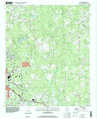 1993 Milstead2000 Print · USGSRockdale and Newton counties are captured here in the early nineties, showing a landscape of river valleys and rural crossroads. Genealogists and historians can trace old community sites like Zingara and Almon, or locate family landmarks such as Philadelphia Ch and Deals Millpond.
 - 1999 Map of Milstead, 2002 Print
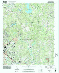 1999 Milstead2002 Print · USGSThe Yellow River valley transitions from its industrial roots to modern development in the late nineties. Researchers can trace historic church sites like Philadelphia Church and early family markers at Almand Cemetery near Conyers.
 - 1999 Map of Conyers, 2003 Print
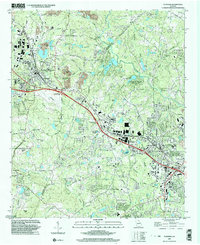 1999 Conyers2003 Print · USGSRockdale and DeKalb counties show significant suburban growth by the late nineties while preserving deep-rooted community landmarks. Genealogists can trace family footprints through numerous rural churches like New Hope Ch and landmarks such as the Bruce St Sch.
End of results
Showing maps 1-3 of 3
Top cities near Conyers
- Stonecrest historical maps
- Tucker historical maps
- Redan historical maps
- Stockbridge historical maps
- McDonough historical maps
- Snellville historical maps
See more
Frequently asked questions
- What are the different types of historical maps available for Conyers?
- What is the oldest map of Conyers?
- Where can I purchase historical maps of Conyers for my home or office?
- Where can I download high-res historical maps of Conyers?
- Are there historical topographic maps available for Conyers?
- Is there historical aerial imagery available for Conyers?
- Where are historical maps of Conyers sourced from?