1970s Maps of Stewart County, Georgia
Explore 6 historic maps of Stewart County from the 1970s. These maps offer a rare glimpse into what life looked like during the 1970s — showing old roads, neighborhoods, homes, and landmarks that have changed or disappeared over time.
Whether you're researching your family's past, planning a metal detecting trip, or studying how Stewart County's landscape evolved across the 1970s, these high-resolution maps are a powerful tool for exploring the history of this region.
- Focus on a specific era: All maps on this page are from the 1970s, giving you a focused view of this time period.
- See what’s changed: Compare century-old streets, trails, and buildings to today's modern landscape using overlays and satellite layers.
- Research with precision: Use these maps for genealogy, historical research, land use analysis, or educational projects.
- View, download, or print: Maps are fully viewable online in high resolution, and can be downloaded or printed for your own records.
Start exploring Stewart County's history through authentic maps from the 1970s. This is your window into the past.
Stewart County, GA maps
(6)- 1972 Map of Sanford, 1974 Print
 1972 Sanford1974 Print · USGSThe rural borderlands of Stewart and Quitman counties are captured in the early 1970s, showcasing a landscape where industry meets traditional country life. Researchers can trace local congregations at Davis Chapel and Mill Bethel Ch or locate family landmarks like Pearces Pond.
 - 1972 Map of Richland, 1974 Print
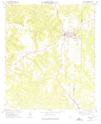 1972 Richland1974 Print · USGSRichland and the surrounding Georgia countryside are shown in the early seventies as a thriving rail-centered hub near the Stewart and Webster county line. Researchers can locate family landmarks including Harmony Cem, Upper Sardis Ch, and the community of Randall.2 unique versions available
 - 1972 Map of Benevolence, 1974 Print
 1972 Benevolence1974 Print · USGSSouthwest Georgia in the 1970s shows a landscape of small crossroads and country parishes. Genealogists can trace family footprints near Benevolence or locate rural landmarks like Mt Pleasant Ch and the Seaboard Coast Line.
 - 1972 Map of County Line, 1974 Print
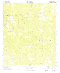
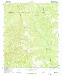
 1972 County Line1974 Print · USGSThe Stewart and Randolph county line in the early seventies was a region of quiet settlements and deep creek valleys. Genealogists and historians can trace family locations near Pumpkin Town, Scienceville, and numerous church cemeteries like Piney Grove Ch.
 - 1973 Map of Brooklyn, 1975 Print
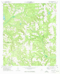
 1973 Brooklyn1975 Print · USGSStewart County at the start of the 1970s is captured here in a moment of rural transition, centered on the Seaboard Coast Line corridor. Genealogists can trace family names and landmarks like Pierson or Slaughter Creek Cemetery, and locate churches such as Red Hill Ch.
 - 1973 Map of Twin Springs, 1976 Print
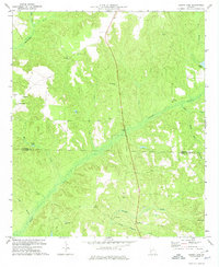
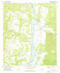 1973 Twin Springs1976 Print · USGSThe Alabama-Georgia borderlands are captured here in the early seventies as the reservoir waters reshaped the river valley. Genealogists can trace family roots through sites like Jernigan Ch Cem, Twin Springs, and the McClendon Cem.2 unique versions available
End of results
Showing maps 1-6 of 6
Top cities of Stewart County
Frequently asked questions
- What are the different types of historical maps available for Stewart County?
- What is the oldest map of Stewart County?
- Where can I purchase historical maps of Stewart County for my home or office?
- Where can I download high-res historical maps of Stewart County?
- Are there historical topographic maps available for Stewart County?
- Is there historical aerial imagery available for Stewart County?
- Where are historical maps of Stewart County sourced from?