1950s Maps of Stewart County, Georgia
Explore 16 historic maps of Stewart County from the 1950s. These maps offer a rare glimpse into what life looked like during the 1950s — showing old roads, neighborhoods, homes, and landmarks that have changed or disappeared over time.
Whether you're researching your family's past, planning a metal detecting trip, or studying how Stewart County's landscape evolved across the 1950s, these high-resolution maps are a powerful tool for exploring the history of this region.
- Focus on a specific era: All maps on this page are from the 1950s, giving you a focused view of this time period.
- See what’s changed: Compare century-old streets, trails, and buildings to today's modern landscape using overlays and satellite layers.
- Research with precision: Use these maps for genealogy, historical research, land use analysis, or educational projects.
- View, download, or print: Maps are fully viewable online in high resolution, and can be downloaded or printed for your own records.
Start exploring Stewart County's history through authentic maps from the 1950s. This is your window into the past.
Stewart County, GA maps
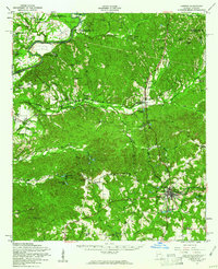
(16)- 1950 Map of Louvale, 1953 Print
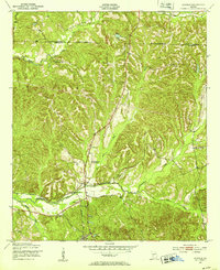 1950 Louvale1953 Print · USGSStewart County at the mid-century mark shows a landscape of rural schoolhouses and rail stops along the Seaboard Line. Trace the locations of Louvale Sch, Bethlehem Ch, and the small community of Mount Olive near the winding Hannahatchee Creek.
 - 1950 Map of Lumpkin, 1953 Print
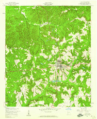
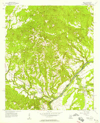
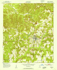 1950 Lumpkin1953 Print · USGSLumpkin and the surrounding Stewart County countryside are captured here in the early postwar years, centered on the Seaboard Air Line railroad. You can trace local genealogy through several rural landmarks, including Snarlers Chapel, Ben Daniel Sch, and the Stewart County Prison Farm.
 - 1950 Map of Lumpkin SW, 1953 Print
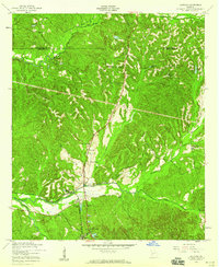
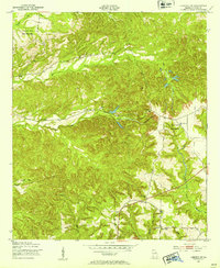 1950 Lumpkin SW1953 Print · USGSStewart County's rural landscape is captured here in the early postwar era, showing the intersection of agricultural life and the region's unique geology. Researchers can trace family history through sites like the James Templeton Cem, Beatrice, and Providence Canyons.
 - 1950 Map of Lumpkin, 1955 Print
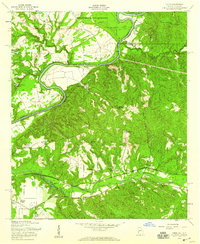
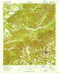 1950 Lumpkin1955 Print · USGSStewart County and the Chattahoochee River valley appear in the mid-fifties as a landscape of deep canyons, family farmsteads, and rail-side settlements. Researchers can trace local genealogy through numerous sites like Fitzgerald Cem, Oak Grove Sch, and Ushers Mill Pond.
 - 1953 Map of Dothan, 1966 Print
 1953 Dothan1966 Print · USGSSoutheast Alabama and Southwest Georgia are captured during a period of massive hydraulic and military expansion in the mid-fifties. Genealogists and historians can trace rural landmarks like Antioch Church and School, the Andrew Jackson Monument, and the early footprint of Fort Rucker Military Reservation.3 unique versions available
 - 1954 Map of Dothan
 1954 Dothan1954 Print · USGSSoutheast Alabama and Southwest Georgia are seen here in the mid-fifties, during a decade of military expansion and rural transition. Genealogists can trace the location of country schools like Little Zion School or the grounds of Kolomoki Mounds State Park.
 - 1955 Map of Dothan
 1955 Dothan1955 Print · USGSSoutheast Alabama and Southwest Georgia are captured here in the mid-fifties, showing a landscape of river-port history and growing military bases. Researchers can trace rural life via the Andrew Jackson Monument, Bauxite mines, and the Central of Georgia RR.
 - 1955 Map of Lumpkin, 1959 Print
 1955 Lumpkin1959 Print · USGSLumpkin and its surrounding Stewart County countryside are captured here in the mid-1950s as a thriving railroad and agricultural hub. Researchers can trace historic family sites and rural infrastructure, from Humbers Mission to the local Dowd Sch and the Seaboard Air Line tracks.3 unique versions available
 - 1955 Map of Louvale, 1959 Print
 1955 Louvale1959 Print · USGSStewart County, Georgia, is captured in the mid-1950s as a landscape of rural schoolhouses and established family churches. Genealogists and local historians can trace legacy sites like Mt Gilead Cem, Louvale Sch, and the Seaboard Air Line RR.3 unique versions available
 - 1955 Map of Lumpkin SW, 1959 Print
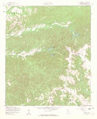 1955 Lumpkin SW1959 Print · USGSMid-century Stewart County remains a landscape of rural schoolhouses and country churches set against the dramatic erosion of the Providence Canyons. Researchers can locate historic family sites and community hubs like James Templeton Cem, Bryan Sch, and Wesley Chapel.4 unique versions available
 - 1955 Map of Union, 1959 Print
 1955 Union1959 Print · USGSStewart County, Georgia, at the midpoint of the century, reveals a landscape of family-named places and military expansion. You can trace early school sites like Crossroads Sch and local gathering spots such as Marvins Store and Antioch Ch.2 unique versions available
 - 1955 Map of Lumpkin, 1961 Print
 1955 Lumpkin1961 Print · USGSIn the mid-1950s, this portion of Stewart County was defined by its dramatic geology and rural church networks. Genealogists and historians can trace family land at Heard Place, locate the Louvale Station on the Seaboard Air Line, or find the Providence Canyons.
 - 1955 Map of Phenix City, 1964 Print
 1955 Phenix City1964 Print · USGSPost-war Alabama and Georgia meet along the Chattahoochee River as industry and military installations expand. Trace the rail lines of the Central of Georgia through towns like Opelika, Tuskegee, and Alexander City.3 unique versions available
 - 1957 Map of Phenix City
 1957 Phenix City1957 Print · USGSThe Alabama-Georgia borderlands are captured here in the mid-fifties, centered on the bustling river crossing at Phenix City and Columbus. Researchers can trace the mid-century footprint of the Fort Benning Military Reservation or locate smaller textile and railroad towns like Langdale and Camp Hill.
 - 1957 Map of Omaha, 1958 Print
 1957 Omaha1958 Print · USGSThe Chattahoochee River valley comes alive in the late fifties, showing the borderlands of Alabama and Georgia. Trace family roots at Wesley Chapel Ch, explore the rail corridor near Cottonton, and locate the old New Mt Cannon Sch.3 unique versions available
 - 1958 Map of Phenix City
 1958 Phenix City1958 Print · USGSThe Alabama-Georgia borderlands thrive during the late fifties, anchored by the river-driven industry of Columbus and Phenix City. Researchers can trace the mid-century footprints of Fort Benning, Auburn, and the textile towns of Fairfax and Lanett.
End of results
Showing maps 1-16 of 16
Top cities of Stewart County
Frequently asked questions
- What are the different types of historical maps available for Stewart County?
- What is the oldest map of Stewart County?
- Where can I purchase historical maps of Stewart County for my home or office?
- Where can I download high-res historical maps of Stewart County?
- Are there historical topographic maps available for Stewart County?
- Is there historical aerial imagery available for Stewart County?
- Where are historical maps of Stewart County sourced from?