Old Maps of Stewart County, Georgia for Academic Research
Study the evolution of Stewart County with 88 high-resolution historic maps. Whether you're teaching, researching, or modeling changes in land use, these maps provide essential visual documentation of urban, environmental, and geographic change.
- Analyze long-term change: Track patterns in development, transportation, and natural features.
- Ideal for environmental or urban studies: Support academic projects with primary historical map data.
- Use in the classroom or lab: Educators and researchers rely on these maps to bring historical context to life.
These maps are a powerful tool for teaching, research, and visualizing how Stewart County has changed over the decades.
Stewart County, GA maps
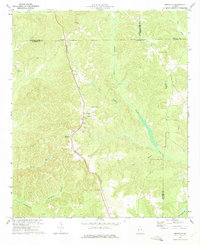
(88)- 1949 Map of Julia
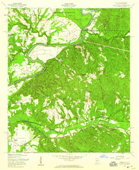
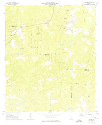
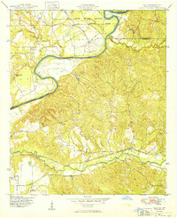 1949 Julia1949 Print · USGSThe river border between Georgia and Alabama comes alive in this post-war survey of the Stewart County backcountry. Genealogists can trace family landholdings like Heard Place and Slayton Place along the Seaboard Air Line and Hannahatchee Creek.2 unique versions available
 - 1950 Map of Louvale, 1953 Print
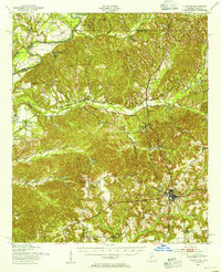
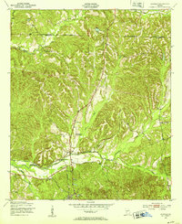 1950 Louvale1953 Print · USGSStewart County at the mid-century mark shows a landscape of rural schoolhouses and rail stops along the Seaboard Line. Trace the locations of Louvale Sch, Bethlehem Ch, and the small community of Mount Olive near the winding Hannahatchee Creek.
 - 1950 Map of Lumpkin, 1953 Print
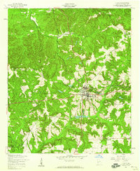
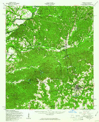
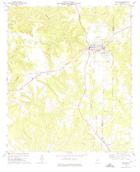
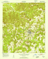 1950 Lumpkin1953 Print · USGSLumpkin and the surrounding Stewart County countryside are captured here in the early postwar years, centered on the Seaboard Air Line railroad. You can trace local genealogy through several rural landmarks, including Snarlers Chapel, Ben Daniel Sch, and the Stewart County Prison Farm.
 - 1950 Map of Lumpkin SW, 1953 Print
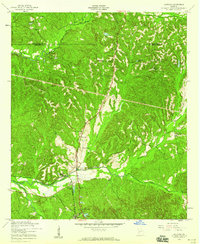
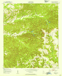 1950 Lumpkin SW1953 Print · USGSStewart County's rural landscape is captured here in the early postwar era, showing the intersection of agricultural life and the region's unique geology. Researchers can trace family history through sites like the James Templeton Cem, Beatrice, and Providence Canyons.
 - 1950 Map of Lumpkin, 1955 Print
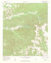
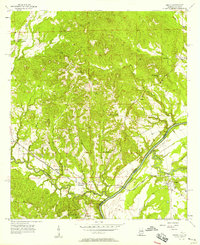
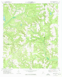
 1950 Lumpkin1955 Print · USGSStewart County and the Chattahoochee River valley appear in the mid-fifties as a landscape of deep canyons, family farmsteads, and rail-side settlements. Researchers can trace local genealogy through numerous sites like Fitzgerald Cem, Oak Grove Sch, and Ushers Mill Pond.
 - 1953 Map of Dothan, 1966 Print
 1953 Dothan1966 Print · USGSSoutheast Alabama and Southwest Georgia are captured during a period of massive hydraulic and military expansion in the mid-fifties. Genealogists and historians can trace rural landmarks like Antioch Church and School, the Andrew Jackson Monument, and the early footprint of Fort Rucker Military Reservation.3 unique versions available
 - 1954 Map of Dothan
 1954 Dothan1954 Print · USGSSoutheast Alabama and Southwest Georgia are seen here in the mid-fifties, during a decade of military expansion and rural transition. Genealogists can trace the location of country schools like Little Zion School or the grounds of Kolomoki Mounds State Park.
 - 1955 Map of Dothan
 1955 Dothan1955 Print · USGSSoutheast Alabama and Southwest Georgia are captured here in the mid-fifties, showing a landscape of river-port history and growing military bases. Researchers can trace rural life via the Andrew Jackson Monument, Bauxite mines, and the Central of Georgia RR.
 - 1955 Map of Lumpkin, 1959 Print
 1955 Lumpkin1959 Print · USGSLumpkin and its surrounding Stewart County countryside are captured here in the mid-1950s as a thriving railroad and agricultural hub. Researchers can trace historic family sites and rural infrastructure, from Humbers Mission to the local Dowd Sch and the Seaboard Air Line tracks.3 unique versions available
 - 1955 Map of Louvale, 1959 Print
 1955 Louvale1959 Print · USGSStewart County, Georgia, is captured in the mid-1950s as a landscape of rural schoolhouses and established family churches. Genealogists and local historians can trace legacy sites like Mt Gilead Cem, Louvale Sch, and the Seaboard Air Line RR.3 unique versions available
 - 1955 Map of Lumpkin SW, 1959 Print
 1955 Lumpkin SW1959 Print · USGSMid-century Stewart County remains a landscape of rural schoolhouses and country churches set against the dramatic erosion of the Providence Canyons. Researchers can locate historic family sites and community hubs like James Templeton Cem, Bryan Sch, and Wesley Chapel.4 unique versions available
 - 1955 Map of Union, 1959 Print
 1955 Union1959 Print · USGSStewart County, Georgia, at the midpoint of the century, reveals a landscape of family-named places and military expansion. You can trace early school sites like Crossroads Sch and local gathering spots such as Marvins Store and Antioch Ch.2 unique versions available
 - 1955 Map of Lumpkin, 1961 Print
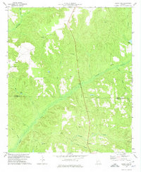
 1955 Lumpkin1961 Print · USGSIn the mid-1950s, this portion of Stewart County was defined by its dramatic geology and rural church networks. Genealogists and historians can trace family land at Heard Place, locate the Louvale Station on the Seaboard Air Line, or find the Providence Canyons.
 - 1955 Map of Phenix City, 1964 Print
 1955 Phenix City1964 Print · USGSPost-war Alabama and Georgia meet along the Chattahoochee River as industry and military installations expand. Trace the rail lines of the Central of Georgia through towns like Opelika, Tuskegee, and Alexander City.3 unique versions available
 - 1957 Map of Phenix City
 1957 Phenix City1957 Print · USGSThe Alabama-Georgia borderlands are captured here in the mid-fifties, centered on the bustling river crossing at Phenix City and Columbus. Researchers can trace the mid-century footprint of the Fort Benning Military Reservation or locate smaller textile and railroad towns like Langdale and Camp Hill.
 - 1957 Map of Omaha, 1958 Print
 1957 Omaha1958 Print · USGSThe Chattahoochee River valley comes alive in the late fifties, showing the borderlands of Alabama and Georgia. Trace family roots at Wesley Chapel Ch, explore the rail corridor near Cottonton, and locate the old New Mt Cannon Sch.3 unique versions available
 - 1958 Map of Phenix City
 1958 Phenix City1958 Print · USGSThe Alabama-Georgia borderlands thrive during the late fifties, anchored by the river-driven industry of Columbus and Phenix City. Researchers can trace the mid-century footprints of Fort Benning, Auburn, and the textile towns of Fairfax and Lanett.
 - 1967 Map of Georgetown, 1970 Print
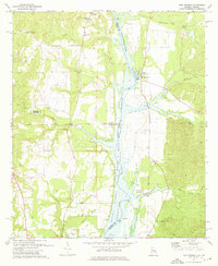
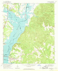 1967 Georgetown1970 Print · USGSThe Quitman County shoreline underwent a dramatic shift in the late sixties as the Chattahoochee River valley was reshaped by new reservoirs. Researchers can trace the submerged geography near Georgetown and locate rural landmarks like Keglar Sch or Bumbleton Courthouse Cem.2 unique versions available
 - 1972 Map of Sanford, 1974 Print
 1972 Sanford1974 Print · USGSThe rural borderlands of Stewart and Quitman counties are captured in the early 1970s, showcasing a landscape where industry meets traditional country life. Researchers can trace local congregations at Davis Chapel and Mill Bethel Ch or locate family landmarks like Pearces Pond.
 - 1972 Map of Richland, 1974 Print
 1972 Richland1974 Print · USGSRichland and the surrounding Georgia countryside are shown in the early seventies as a thriving rail-centered hub near the Stewart and Webster county line. Researchers can locate family landmarks including Harmony Cem, Upper Sardis Ch, and the community of Randall.2 unique versions available
 - 1972 Map of Benevolence, 1974 Print
 1972 Benevolence1974 Print · USGSSouthwest Georgia in the 1970s shows a landscape of small crossroads and country parishes. Genealogists can trace family footprints near Benevolence or locate rural landmarks like Mt Pleasant Ch and the Seaboard Coast Line.
 - 1972 Map of County Line, 1974 Print
 1972 County Line1974 Print · USGSThe Stewart and Randolph county line in the early seventies was a region of quiet settlements and deep creek valleys. Genealogists and historians can trace family locations near Pumpkin Town, Scienceville, and numerous church cemeteries like Piney Grove Ch.
 - 1973 Map of Brooklyn, 1975 Print
 1973 Brooklyn1975 Print · USGSStewart County at the start of the 1970s is captured here in a moment of rural transition, centered on the Seaboard Coast Line corridor. Genealogists can trace family names and landmarks like Pierson or Slaughter Creek Cemetery, and locate churches such as Red Hill Ch.
 - 1973 Map of Twin Springs, 1976 Print
 1973 Twin Springs1976 Print · USGSThe Alabama-Georgia borderlands are captured here in the early seventies as the reservoir waters reshaped the river valley. Genealogists can trace family roots through sites like Jernigan Ch Cem, Twin Springs, and the McClendon Cem.2 unique versions available
 - 1981 Map of Albany, 1982 Print
 1981 Albany1982 Print · USGSSouthwest Georgia in the early eighties was a region defined by its rail hubs and winding river systems. Here you can trace the agricultural landscape from Albany to Dawson, locating sites like Radium Springs, the U S Naval Reservation, and the historic junction at Shellman.
Showing maps 1-25 of 88
Top cities of Stewart County
Frequently asked questions
- What are the different types of historical maps available for Stewart County?
- What is the oldest map of Stewart County?
- Where can I purchase historical maps of Stewart County for my home or office?
- Where can I download high-res historical maps of Stewart County?
- Are there historical topographic maps available for Stewart County?
- Is there historical aerial imagery available for Stewart County?
- Where are historical maps of Stewart County sourced from?