
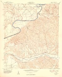
1949 Map of Julia
USGS Topo · Published 1949About this map
Chattahoochee River curves through this landscape at the intersection of Alabama and Georgia, defining the border between Russell, Stewart, and Chattahoochee Counties. The northern reach is dominated by the Fort Benning Military Reservation, while the land to the south reflects a rural economy of the late 1940s. A network of family-named homesteads and small settlements are scattered throughout the hills, including Upper Bradley Place, Slayton Place, Gillis Place, and Heard Place.
Find a feature on this map
22 named features on this map. Tap any name to fly to it.
Don’t see what you’re looking for? This feature index may not catch every label — zoom into the map to look around manually.
Map Details
Editions of this 1949 Julia Map
2 editions found
Other maps of this area

1908 · Columbus
USGS Topo · 1:62,500

1914 · Seale
USGS Topo · 1:62,500

1929 · Columbus
USGS Topo · 1:48,000

1947 · Columbus
USGS Topo · 1:62,500

1949 · Fort Mitchell
USGS Topo · 1:24,000

1949 · Cusseta
USGS Topo · 1:24,000

1950 · Fort Benning
USGS Topo · 1:24,000

1950 · Louvale
USGS Topo · 1:24,000

1950 · Lumpkin
USGS Topo · 1:24,000

1950 · Lumpkin SW
USGS Topo · 1:24,000