1930s Maps of Walker County, Georgia
Explore 12 historic maps of Walker County from the 1930s. These maps offer a rare glimpse into what life looked like during the 1930s — showing old roads, neighborhoods, homes, and landmarks that have changed or disappeared over time.
Whether you're researching your family's past, planning a metal detecting trip, or studying how Walker County's landscape evolved across the 1930s, these high-resolution maps are a powerful tool for exploring the history of this region.
- Focus on a specific era: All maps on this page are from the 1930s, giving you a focused view of this time period.
- See what’s changed: Compare century-old streets, trails, and buildings to today's modern landscape using overlays and satellite layers.
- Research with precision: Use these maps for genealogy, historical research, land use analysis, or educational projects.
- View, download, or print: Maps are fully viewable online in high resolution, and can be downloaded or printed for your own records.
Start exploring Walker County's history through authentic maps from the 1930s. This is your window into the past.
Walker County, GA maps
(12)- 1935 Map of Catlett
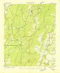
 1935 Catlett1935 Print · USGSThe Walker and Whitfield county line comes alive in the mid-1930s, showing a rural Georgia landscape of high ridges and valley farms. Researchers can trace family ties at Gladden Cem or locate the old Pine Grove Sch and Henderson Sch near the crossing of Catlett Creek.
 - 1935 Map of Durham
 1935 Durham1935 Print · USGSNorthwest Georgia's industrial and rural landscape is documented here during the mid-1930s as mining and rail commerce defined the region. Researchers can trace the heritage of Durham and Cassandra through sites like Coal Mines, Prospect Sch, and Fuggett Ch.
 - 1935 Map of Villanow
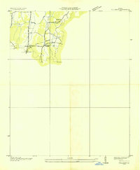 1935 Villanow1935 Print · USGSThe borderlands of Whitfield and Walker Counties are captured here in the mid-1930s as the TVA began its regional work. Genealogists can locate rural landmarks like Friendship Ch, Fairview Sch, and the small settlement of Reo.
 - 1935 Map of Nickajack Gap
 1935 Nickajack Gap1935 Print · USGSCatoosa and Walker Counties are captured in the mid-1930s as a landscape of ridges and rural settlements. Researchers can locate family landmarks like Mc Intyre Cem, Peavine Ch, and the school at Mt Pisgah Sch.
 - 1936 Map of Kensington
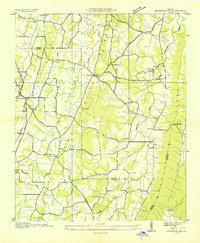
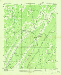
 1936 Kensington1936 Print · USGSWalker County during the mid-1930s shows a landscape of ridge-and-valley settlements connected by the Central of Georgia line. Genealogists and historians can trace family locations near Old Lookout Cem, Pond Spring, and the Gordon Lee Sch.
 - 1936 Map of Hooker
 1936 Hooker1936 Print · USGSNorthwest Georgia and neighboring Tennessee appear here in the mid-thirties, showing a landscape defined by mountain gaps and river valleys. Researchers can trace the path of Southern Railway through Morganville or locate family sites like Bethlehem Cem and Slygo Ch.
 - 1936 Map of Sulphur Springs
 1936 Sulphur Springs1936 Print · USGSLookout Mountain and the Alabama-Georgia borderlands are captured here in the mid-1930s. Researchers can trace families near Sulphur Springs or find landmarks like Amos Mill, Battelle, and the Lookout Chapel Sch.
 - 1936 Map of Estelle
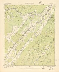
 1936 Estelle1936 Print · USGSWalker County during the mid-1930s shows a landscape of steep ridges and tucked-away hollows. Genealogists and historians can trace the Tenn Ala & Ga RR past Estelle or locate the Valley Head Ch near the dramatic slopes of Pigeon Mountain.
 - 1936 Map of Fort Oglethorpe
 1936 Fort Oglethorpe1936 Print · USGSThe Georgia-Tennessee borderlands appear here in the mid-1930s, featuring the extensive grounds of the Chickamauga battlefield and the early development of Lookout Mountain. Researchers can locate historic farmsteads and monuments such as the Snodgrass House, the Lee and Gordon Mill, and Rock City Gardens.
 - 1936 Map of Dougherty Gap
 1936 Dougherty Gap1936 Print · USGSNorthern Georgia mountain terrain comes into focus in the mid-1930s as federal agencies mapped the convergence of LOOKOUT MOUNTAIN and PIGEON MOUNTAIN. Genealogists and historians can trace the early road through Dougherty Gap and locate the site of a CCC Camp (Abandoned).
 - 1936 Map of Cedar Grove
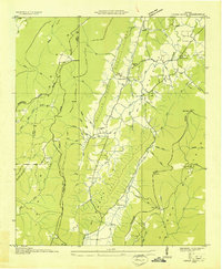 1936 Cedar Grove1936 Print · USGSWalker County's ridge-and-valley landscape is captured here in the mid-1930s as rural life centered on the fertile McLemore Cove. Genealogists can locate family landmarks such as Thurman Cem, Antioch Ch, and the settlement of Masseyville.
 - 1936 Map of Little Falls
 1936 Little Falls1936 Print · USGSDeKalb County, Alabama, is captured in the mid-1930s just as the Tennessee Valley Authority began modernizing the region. Researchers can trace rural life through the upland community of Violet Hill, its Violet Hill Ch, and the high ridges of Lookout Mountain.
End of results
Showing maps 1-12 of 12
Top cities of Walker County
- LaFayette historical maps
- Rossville historical maps
- Chickamauga historical maps
- Lookout Mountain historical maps
Frequently asked questions
- What are the different types of historical maps available for Walker County?
- What is the oldest map of Walker County?
- Where can I purchase historical maps of Walker County for my home or office?
- Where can I download high-res historical maps of Walker County?
- Are there historical topographic maps available for Walker County?
- Is there historical aerial imagery available for Walker County?
- Where are historical maps of Walker County sourced from?