1950s Maps of Bonner County, Idaho
Explore 8 historic maps of Bonner County from the 1950s. These maps offer a rare glimpse into what life looked like during the 1950s — showing old roads, neighborhoods, homes, and landmarks that have changed or disappeared over time.
Whether you're researching your family's past, planning a metal detecting trip, or studying how Bonner County's landscape evolved across the 1950s, these high-resolution maps are a powerful tool for exploring the history of this region.
- Focus on a specific era: All maps on this page are from the 1950s, giving you a focused view of this time period.
- See what’s changed: Compare century-old streets, trails, and buildings to today's modern landscape using overlays and satellite layers.
- Research with precision: Use these maps for genealogy, historical research, land use analysis, or educational projects.
- View, download, or print: Maps are fully viewable online in high resolution, and can be downloaded or printed for your own records.
Start exploring Bonner County's history through authentic maps from the 1950s. This is your window into the past.
Bonner County, ID maps
(8)- 1950 Map of Mt Spokane, 1952 Print
 1950 Mt Spokane1952 Print · USGSThe Washington-Idaho borderlands in the early fifties reveal a landscape of high summits and quiet lake basins. Genealogists and local historians can trace rural school districts like Kit Carson School and small community hubs such as Inland Grange and Peone.3 unique versions available
 - 1951 Map of Packsaddle Mtn
 1951 Packsaddle Mtn1951 Print · USGSLake Pend Oreille was a hub of mining and rail transit in the early fifties, with many settlements and extraction sites lining its shores. Researchers can locate the Broten PO, trace the Northern Pacific tracks, and find operations like the Green Monarch Mine.2 unique versions available
 - 1951 Map of Clark Fork, 1952 Print
 1951 Clark Fork1952 Print · USGSThe Idaho-Montana borderlands are captured here in the early 1950s just as the river valley was preparing for major hydroelectric changes. Researchers can trace the legacy of local mining at Whitedelf Mine or locate early school sites like the River Echo Sch (Aband).4 unique versions available
 - 1951 Map of Mt Pend Oreille, 1952 Print
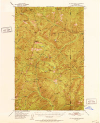 1951 Mt Pend Oreille1952 Print · USGSThe Cabinet Mountains along the Idaho-Montana border are shown here in the early fifties, detailing a wilderness of forest lookouts and isolated mining claims. Researchers can find backcountry outposts like Smith Cabin and the Auxor Mine, along with numerous alpine waters such as Lake Estelle.4 unique versions available
 - 1951 Map of Elmira, 1953 Print
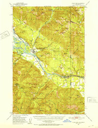
 1951 Elmira1953 Print · USGSNorthern Idaho's timber and rail country is captured here in the early fifties, just before the Albeni Falls Dam changed the shoreline of Pend Oreille Lake. Genealogists can trace several vanished rural schoolhouses, such as Pack River School and the Oden Sch (Aban'd).3 unique versions available
 - 1955 Map of Spokane, 1965 Print
 1955 Spokane1965 Print · USGSInland Empire life in the fifties and sixties centers on the growth of Spokane and the heavy mining industry of northern Idaho. Trace mid-century landmarks like Fairchild Air Force Base, the Bunker Hill Mine, and early campuses such as Gonzaga University.2 unique versions available
 - 1958 Map of Spokane
 1958 Spokane1958 Print · USGSThe Inland Empire is shown at a mid-century peak of industrial and military activity, from the rail hubs of Spokane to the deep silver mines of northern Idaho. Researchers can trace the sprawling rail lines of the Union Pacific RR or locate landmarks like Fairchild Air Force Base and the Bunker Hill Smelter & Mine.
 - 1958 Map of Sandpoint, 1966 Print
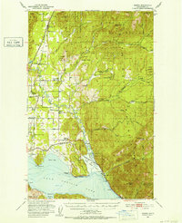
 1958 Sandpoint1966 Print · USGSThe Idaho Panhandle and Northeast Washington are shown here in the late fifties, when timber and hydroelectric power drove the local economy. Trace family roots in rail-side towns like Cusick or Metaline Falls, and locate landmarks like the Albeni Falls Dam or Falls Ranger Station.2 unique versions available
End of results
Showing maps 1-8 of 8
Top cities of Bonner County
- Sandpoint historical maps
- Priest River historical maps
- Ponderay historical maps
- Clark Fork historical maps
- Dover historical maps
- Kootenai historical maps
See more
Frequently asked questions
- What are the different types of historical maps available for Bonner County?
- What is the oldest map of Bonner County?
- Where can I purchase historical maps of Bonner County for my home or office?
- Where can I download high-res historical maps of Bonner County?
- Are there historical topographic maps available for Bonner County?
- Is there historical aerial imagery available for Bonner County?
- Where are historical maps of Bonner County sourced from?