1980s Maps of Bonner County, Idaho
Explore 22 historic maps of Bonner County from the 1980s. These maps offer a rare glimpse into what life looked like during the 1980s — showing old roads, neighborhoods, homes, and landmarks that have changed or disappeared over time.
Whether you're researching your family's past, planning a metal detecting trip, or studying how Bonner County's landscape evolved across the 1980s, these high-resolution maps are a powerful tool for exploring the history of this region.
- Focus on a specific era: All maps on this page are from the 1980s, giving you a focused view of this time period.
- See what’s changed: Compare century-old streets, trails, and buildings to today's modern landscape using overlays and satellite layers.
- Research with precision: Use these maps for genealogy, historical research, land use analysis, or educational projects.
- View, download, or print: Maps are fully viewable online in high resolution, and can be downloaded or printed for your own records.
Start exploring Bonner County's history through authentic maps from the 1980s. This is your window into the past.
Bonner County, ID maps
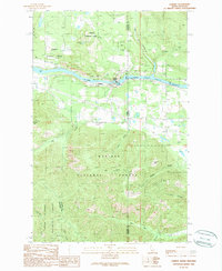
(22)- 1983 Map of Bonners Ferry
 1983 Bonners Ferry1983 Print · USGSThe Idaho Panhandle and its international border with Canada are shown here in the early 1980s as the timber and mining industries shaped the landscape. Genealogists and researchers can locate northern settlements like Porthill and Naples, alongside family-named peaks and mines such as the American Girl Mine and Parker Mtn.2 unique versions available
 - 1984 Map of Colville
 1984 Colville1984 Print · USGSNortheastern Washington and the Idaho borderlands are documented here in the mid-1980s as the regional economy balanced forestry and mineral extraction. Genealogists and researchers can trace dozens of mountain mining operations like Van Stone Mine alongside timber settlements such as Metaline Falls and Aladdin.2 unique versions available
 - 1984 Map of Sandpoint
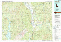
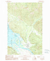
 1984 Sandpoint1984 Print · USGSThe Idaho Panhandle in the early 1980s shows a landscape of deep lakes and working forests centered on the rail hub of Sandpoint. Researchers can trace the legacy of regional industry through the Spokane International rail lines and mining sites like the Gold Coin Mine and Sulphide Mine.2 unique versions available
 - 1984 Map of Chewelah
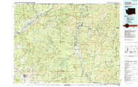
 1984 Chewelah1984 Print · USGSNortheastern Washington in the mid-1980s is documented here through its valley settlements and mountain mining districts. Researchers can trace the Burlington Northern line between Springdale and Addy, or locate historical operations like the Wells Fargo Mine and Keystone Mine.
 - 1987 Map of Spokane
 1987 Spokane1987 Print · USGSGreater Spokane and its surrounding prairies are captured in the late 1980s as the region solidified its role as a regional hub. Researchers can trace family sites near Medical Lake, military life at Fairchild Air Force Base, and rural settlements like Peone and Chattaroy.
 - 1987 Map of Coeur D'Alene
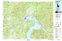
 1987 Coeur D'Alene1987 Print · USGSNorthern Idaho in the late eighties shows a landscape of deep-water lakes and heavy industry where the timber and mining economies meet growing valley settlements. Genealogists and historians can trace the footprints of the Sunshine Mine, the rail sidings at Corbin Junction, and the historic Old Mission State Park.3 unique versions available
 - 1989 Map of Trestle Peak
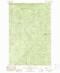
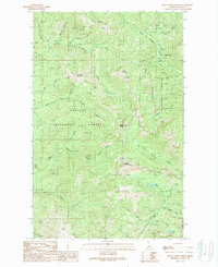
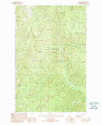 1989 Trestle Peak1989 Print · USGSBonner County’s high country in the late eighties was a landscape of remote mineral claims and primitive forest paths. Trace the old mining routes near the Auxor Mine or locate high-altitude landmarks like Trestle Peak and the waters of Char Falls.
 - 1989 Map of Minerva Peak
 1989 Minerva Peak1989 Print · USGSThe eastern shore of Lake Pend Oreille appears here in the late eighties, showing a landscape defined by forest service boundaries and remote mining history. Researchers can locate the Clara Cemetery and trace the sites of the Minerva Mine and Falls Creek Mine near Blacktail.
 - 1989 Map of Benning Mountain
 1989 Benning Mountain1989 Print · USGSThe high Cabinet Mountains wilderness along the Idaho-Montana border is documented here in the late eighties. Track the forested divide between Kootenai National Forest and Kaniksu National Forest near Benning Mountain and Moose Lake.
 - 1989 Map of Oden Bay
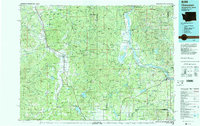
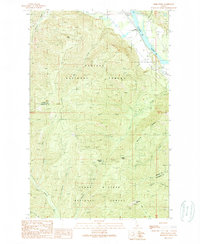
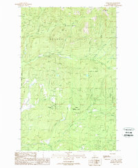
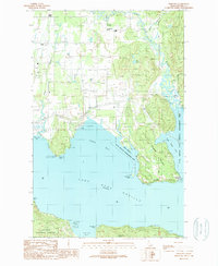 1989 Oden Bay1989 Print · USGSLake Pend Oreille and the Pack River delta define this Idaho landscape in the late 1980s. Local researchers can locate the Pack River Cemetery, the North Side Sch, and the historical community at Selle or the Oden (Site).
 - 1989 Map of Packsaddle Mountain
 1989 Packsaddle Mountain1989 Print · USGSThe Idaho Panhandle backcountry is captured here in the late eighties as it straddles the Bonner and Shoshone county line. Trace the remote mining and forestry history of the region through landmarks like the Green Monarch Mine, the Larch Mountain Trail, and Packsaddle Mountain.
 - 1989 Map of Elmira
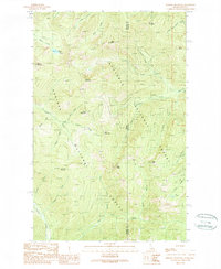
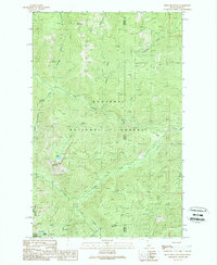
 1989 Elmira1989 Print · USGSIn the late eighties, the Pack River valley in Bonner County was a landscape of mountain timber and riparian wetlands. Researchers can trace the rail corridor through Elmira and Samuels or locate rural industry at the Gravel Pits and the local Substation.
 - 1989 Map of Cabinet
 1989 Cabinet1989 Print · USGSThe Idaho-Montana borderlands are captured here in the late eighties as industrial and natural interests meet at the Clark Fork. Researchers can locate the settlement of Cabinet, the historic Carpie Mine, and the local cemetery near the gorge.
 - 1989 Map of Talache
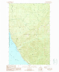
 1989 Talache1989 Print · USGSThe western shoreline of Lake Pend Oreille reveals its mining and timber roots during the late twentieth century. Researchers can trace historical sites like the Garfield (Midas) Gold Coin Mine, the Newman Sch, and local cemeteries near Talache.
 - 1989 Map of Clark Fork
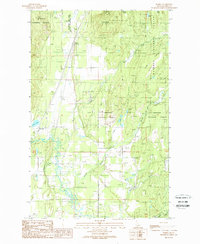
 1989 Clark Fork1989 Print · USGSIn the late eighties, the town of Clark Fork thrived at the confluence of the river and Pend Oreille Lake. Researchers and historians can locate mining sites like Whitedelf Mine and the University of Idaho Field Campus.
 - 1989 Map of Derr Point
 1989 Derr Point1989 Print · USGSThe Idaho panhandle wilderness is captured here in the late eighties, where the Clark Fork river meets the forest. Researchers can trace the steep topography around Derr Point, old pack routes like the Larch Mtn Trail, and the isolated Colby settlement.
 - 1989 Map of Smith Mountain
 1989 Smith Mountain1989 Print · USGSThe Idaho and Montana borderlands are seen here in the late twentieth century, dominated by the high ridgelines of the Cabinet Mountains. Researchers can trace the drainages of Callahan Creek and find specific landmarks like Smith Lake and Lake Estelle.
 - 1989 Map of Scotchman Peak
 1989 Scotchman Peak1989 Print · USGSThe Idaho-Montana borderlands are mapped here in the late eighties, documenting the wild drainages of the Kaniksu National Forest. Trace backcountry routes to the Open Pit Mine or high summits like Scotchman Peak and Savage Mountain.
 - 1989 Map of Mount Pend Oreille
 1989 Mount Pend Oreille1989 Print · USGSThe high Idaho panhandle backcountry is revealed in the late eighties, showing the divide between the Kaniksu and Kootenai forests. Researchers can trace remote mountain activity through the Smith Cabin, the Open Pit Mine, and Lake Darling.
 - 1989 Map of Hope
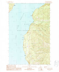
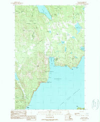
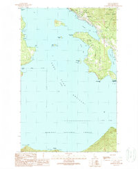 1989 Hope1989 Print · USGSLake Pend Oreille and its northern shore communities come into focus during the late 1980s as recreation and conservation efforts matured. Local historians can locate the Lighthouse on Pearl Island, the Green Monarch Mine, and the early layout of East Hope.
 - 1989 Map of Trout Peak
 1989 Trout Peak1989 Print · USGSThe northern shores of Lake Pend Oreille in the late 1980s show a landscape where the Kaniksu National Forest meets the water. You can trace the shoreline settlements of Trestle Creek and Hope or locate high-altitude Prospect Adits near Grief Mountain.
 - 1989 Map of Wylie Knob
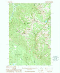
 1989 Wylie Knob1989 Print · USGSBonner County, Idaho, is shown at the close of the 1980s as a region of steep drainages and national forest peaks. Researchers can locate remote landmarks like Grouse Creek Falls, trace the paths of Rapid Lightning Creek, and find landforms like Wylie Knob.
End of results
Showing maps 1-22 of 22
Top cities of Bonner County
- Sandpoint historical maps
- Priest River historical maps
- Ponderay historical maps
- Clark Fork historical maps
- Dover historical maps
- Kootenai historical maps
See more
Frequently asked questions
- What are the different types of historical maps available for Bonner County?
- What is the oldest map of Bonner County?
- Where can I purchase historical maps of Bonner County for my home or office?
- Where can I download high-res historical maps of Bonner County?
- Are there historical topographic maps available for Bonner County?
- Is there historical aerial imagery available for Bonner County?
- Where are historical maps of Bonner County sourced from?