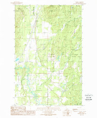
1989 Map of Elmira
USGS Topo · Published 1989About this map
The Pack River meanders through the southern flats of this Bonner County landscape, creating a complex network of wetlands and channels before the terrain rises into the surrounding timberlands. In the late 1980s, the small settlements of Elmira and Samuels served as focal points along the primary north-south transport corridor, which is closely paralleled by a significant Pipeline. The map captures the interface between managed wilderness and local industry, showing the boundaries of the Kaniksu National Forest and the Mc Arthur Lake State Wildlife Management Area alongside active Gravel Pits.
Find a feature on this map
32 named features on this map. Tap any name to fly to it.
Don’t see what you’re looking for? This feature index may not catch every label — zoom into the map to look around manually.
Map Details
Editions of this 1989 Elmira Map
This is the sole edition of this map. No revisions or reprints were ever made.
Other maps of this area

1901 · Sandpoint
USGS Topo · 1:125,000

1911 · Priest Lake
USGS Topo · 1:250,000

1911 · Sandpoint
USGS Topo · 1:125,000

1913 · Priest Lake
USGS Topo · 1:250,000

1951 · Elmira
USGS Topo · 1:62,500

1958 · Sandpoint
USGS Topo · 1:250,000

1963 · Sandpoint
USGS Topo · 1:250,000

1965 · Twentymile Creek
USGS Topo · 1:24,000

1965 · Naples
USGS Topo · 1:24,000
1967 · Dodge Peak
USGS Topo · 1:24,000