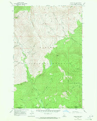
1967 Map of Dodge Peak
USGS Topo · Published 1971About this map
Kaniksu National Forest defines the high-altitude landscape of this 1967 survey, where the drainages of the Pack River and several major creeks carve through the Selkirk Mountains. The topography is dominated by massive landforms including Apache Ridge and Jeru Ridge, leading up to prominent summits like Dodge Peak and White Mtn. The network of watercourses is dense, with Fall Creek, Ruby Creek, and Deep Creek feeding the larger river systems that define the watershed.
Find a feature on this map
25 named features on this map. Tap any name to fly to it.
Don’t see what you’re looking for? This feature index may not catch every label — zoom into the map to look around manually.
Map Details
Editions of this 1967 Dodge Peak Map
3 editions found
Other maps of this area

1901 · Sandpoint
USGS Topo · 1:125,000

1911 · Priest Lake
USGS Topo · 1:250,000

1911 · Sandpoint
USGS Topo · 1:125,000

1913 · Priest Lake
USGS Topo · 1:250,000

1951 · Elmira
USGS Topo · 1:62,500

1958 · Sandpoint
USGS Topo · 1:250,000

1963 · Sandpoint
USGS Topo · 1:250,000

1965 · Moravia
USGS Topo · 1:24,000

1965 · Naples
USGS Topo · 1:24,000

1967 · The Wigwams
USGS Topo · 1:24,000