
1965 Map of Naples
USGS Topo · Published 1967About this map
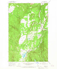
Naples and the surrounding timberlands of the Kaniksu National Forest are defined by a critical corridor of mountain transportation and water management. During the mid-1960s, the valley floor served as a shared route for the Great Northern and Spokane International railroads, which parallel Deep Creek through the heart of the region. To the south, the McArthur Lake State Wildlife Management Area preserves a significant water body near the Boundary and Bonner County line. The map captures the social hubs of this rural community, including the Highland Flats Community Hall and small settlements like Shiloh and McArthur. To the west, the terrain rises sharply toward Ruby Ridge and Molar Highland, where numerous drainages such as Fall Creek and Cooks Creek cut through the steep slopes of the panhandle landscape.
Find a feature on this map
40 named features on this map. Tap any name to fly to it.
Don’t see what you’re looking for? This feature index may not catch every label — zoom into the map to look around manually.
Map Details
Editions of this 1965 Naples Map
2 editions found
Other maps of this area

1901 · Sandpoint
USGS Topo · 1:125,000

1911 · Priest Lake
USGS Topo · 1:250,000

1911 · Sandpoint
USGS Topo · 1:125,000

1913 · Priest Lake
USGS Topo · 1:250,000

1951 · Elmira
USGS Topo · 1:62,500

1958 · Sandpoint
USGS Topo · 1:250,000

1963 · Sandpoint
USGS Topo · 1:250,000

1965 · Twentymile Creek
USGS Topo · 1:24,000

1965 · Moravia
USGS Topo · 1:24,000
1965 · Bonners Ferry
USGS Topo · 1:24,000