1940s Maps of Bonner County, Idaho
Explore 4 historic maps of Bonner County from the 1940s. These maps offer a rare glimpse into what life looked like during the 1940s — showing old roads, neighborhoods, homes, and landmarks that have changed or disappeared over time.
Whether you're researching your family's past, planning a metal detecting trip, or studying how Bonner County's landscape evolved across the 1940s, these high-resolution maps are a powerful tool for exploring the history of this region.
- Focus on a specific era: All maps on this page are from the 1940s, giving you a focused view of this time period.
- See what’s changed: Compare century-old streets, trails, and buildings to today's modern landscape using overlays and satellite layers.
- Research with precision: Use these maps for genealogy, historical research, land use analysis, or educational projects.
- View, download, or print: Maps are fully viewable online in high resolution, and can be downloaded or printed for your own records.
Start exploring Bonner County's history through authentic maps from the 1940s. This is your window into the past.
Bonner County, ID maps
(4)- 1942 Map of Metaline
 1942 Metaline1942 Print · USGSThe Pend Oreille River valley and the surrounding Selkirk Mountains are shown here in the early 1940s, during a period of intense mining and timber activity. Genealogists and historians can trace rail-side settlements like Ione and Tiger or locate mining sites such as Josephine Mine and Bunker Hill Mines.3 unique versions available
 - 1942 Map of Newport
 1942 Newport1942 Print · USGSPend Oreille River country is captured here during the early 1940s, showing the vital rail and river links between Newport and the mountain frontier. Researchers can trace family homesteads near old schools like Fertile Valley Sch or locate the Indian Mission and Dalkena mill site.3 unique versions available
 - 1943 Map of Mt Spokane
 1943 Mt Spokane1943 Print · USGSThe Washington and Idaho borderlands are shown here during the early years of the state park's development. Genealogists and local historians can trace rural school districts like Blanchard Valley Sch and old supply points like the Peone Store.2 unique versions available
 - 1949 Map of Packsaddle Mtn, 1959 Print
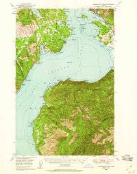 1949 Packsaddle Mtn1959 Print · USGSLake Pend Oreille and the surrounding national forests are captured here in the late 1940s as rail and mining operations shaped the rugged terrain. Genealogists and historians can locate old post offices like Broten PO and remote sites such as Whisky Rock or the Green Monarch Mine.3 unique versions available
End of results
Showing maps 1-4 of 4
Top cities of Bonner County
- Sandpoint historical maps
- Priest River historical maps
- Ponderay historical maps
- Clark Fork historical maps
- Dover historical maps
- Kootenai historical maps
See more
Frequently asked questions
- What are the different types of historical maps available for Bonner County?
- What is the oldest map of Bonner County?
- Where can I purchase historical maps of Bonner County for my home or office?
- Where can I download high-res historical maps of Bonner County?
- Are there historical topographic maps available for Bonner County?
- Is there historical aerial imagery available for Bonner County?
- Where are historical maps of Bonner County sourced from?