1990s Maps of Bonner County, Idaho
Explore 56 historic maps of Bonner County from the 1990s. These maps offer a rare glimpse into what life looked like during the 1990s — showing old roads, neighborhoods, homes, and landmarks that have changed or disappeared over time.
Whether you're researching your family's past, planning a metal detecting trip, or studying how Bonner County's landscape evolved across the 1990s, these high-resolution maps are a powerful tool for exploring the history of this region.
- Focus on a specific era: All maps on this page are from the 1990s, giving you a focused view of this time period.
- See what’s changed: Compare century-old streets, trails, and buildings to today's modern landscape using overlays and satellite layers.
- Research with precision: Use these maps for genealogy, historical research, land use analysis, or educational projects.
- View, download, or print: Maps are fully viewable online in high resolution, and can be downloaded or printed for your own records.
Start exploring Bonner County's history through authentic maps from the 1990s. This is your window into the past.
Bonner County, ID maps
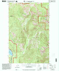
(56)- 1990 Map of Faset Peak, 1991 Print
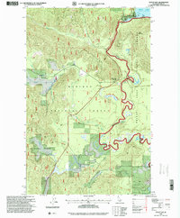
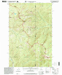
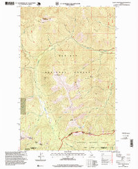
 1990 Faset Peak1991 Print · USGSThe high ridges of Shoshone and Bonner counties are documented here in the early 1990s as the national forests were managed for both timber and recreation. Researchers can trace the winding Ermine Ridge Trail, locate the INDEPENDENCE site, and follow the drainages of Spruce Creek.
 - 1996 Map of Outlet Bay, 1999 Print
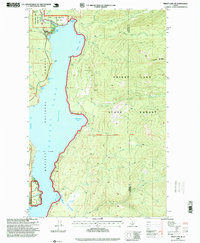
 1996 Outlet Bay1999 Print · USGSThe southern shores of Priest Lake meet the Kaniksu National Forest in the late nineties, documenting the critical water management around Outlet Bay. Trace the river's path from the Outlet Dam past Mission Falls and Dickensheet Junction.
 - 1996 Map of Mount Pend Oreille, 1999 Print
 1996 Mount Pend Oreille1999 Print · USGSThe Cabinet Mountains in the mid-1990s were a hub of national forest management and mineral exploration on the Idaho-Montana border. Researchers can trace resource history and high-elevation topography through features like the Open Pit Mine, Smith Cabin, and Lake Darling.
 - 1996 Map of Jordan Creek, 1999 Print
 1996 Jordan Creek1999 Print · USGSThe Bitterroot mountains and the Idaho-Montana state line meet here in the late twentieth century. Researchers can trace historic access routes like the National Recreation Trail and find landmarks such as Jordan Camp and Spion Kop Rock.
 - 1996 Map of Prater Mountain, 1999 Print
 1996 Prater Mountain1999 Print · USGSNorthern Idaho's timber and research history is captured here in the mid-1990s. Genealogists and researchers can trace the roads around the Experimental Forest Headquarters or find landmarks like McAbee Falls and the Halfway House.
 - 1996 Map of Wylie Knob, 1999 Print
 1996 Wylie Knob1999 Print · USGSThe Idaho panhandle near the turn of the millennium shows a landscape of mountain peaks and forest drainages. Researchers can trace the path of Rapid Lightning Creek and locate landmarks like Wylie Knob or the Grouse Creek Falls in the heart of the Kaniksu National Forest.
 - 1996 Map of Benning Mountain, 1999 Print
 1996 Benning Mountain1999 Print · USGSThe high Idaho-Montana borderlands are captured here in the mid-1990s, where the Kootenai meets the Kaniksu. Researchers can trace the rugged divide between Bonner and Lincoln counties through summits like Benning Mountain and Twin Peaks.
 - 1996 Map of Priest River, 1999 Print
 1996 Priest River1999 Print · USGSPriest River and the Pend Oreille River valley are captured in the mid-1990s as the regional timber and recreation economies evolved. Researchers can locate the Bodie Canyon Mine, the Albeni Falls Dam, and civic landmarks like Priest River High School and the local Cem.
 - 1996 Map of Priest Lake SE, 1999 Print
 1996 Priest Lake SE1999 Print · USGSThe eastern shores of Priest Lake in the mid-1990s reveal a landscape shaped by national forests and lakefront settlements. Researchers can trace the layout of Fenton, find the Vinttler-Nelson Historical Cabin on its island, or locate the Cavanaugh Bay Airport.
 - 1996 Map of Quartz Mountain, 1999 Print
 1996 Quartz Mountain1999 Print · USGSBonner County is captured here in the mid-nineties, showing the forest management and hydrological landscape of the Panhandle. Trace old logging routes and survey markers near Quartz Mountain, Four Corners, and the West Branch Priest River.
 - 1996 Map of Clifty Mountain, 1999 Print
 1996 Clifty Mountain1999 Print · USGSThe northern Idaho backcountry in the late nineties is detailed here, showing the intersection of two national forests. You can trace the Katka Trail or locate remote sites like the Boulder Mine and the shores of Divide Lake.
 - 1996 Map of Priest Lake NE, 1999 Print
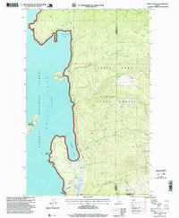
 1996 Priest Lake NE1999 Print · USGSUpper Priest Lake and the surrounding Kaniksu National Forest are shown in the late nineties, documenting the shoreline before modern expansion. Trace backcountry routes along the Lakeshore Trail and locate sites like Camp Lodge and The Thorofare.
 - 1996 Map of Faset Peak, 1999 Print
 1996 Faset Peak1999 Print · USGSThe mountain backcountry of Shoshone and Bonner counties is captured here in the mid-1990s as it was managed by the Forest Service. Trace the high-altitude trails and springs of the Panhandle, from Faset Peak and Bishop Spring to the National Recreation Trail.
 - 1996 Map of Minerva Peak, 1999 Print
 1996 Minerva Peak1999 Print · USGSThe eastern shores of Lake Pend Oreille and the high ridges of the Kaniksu National Forest are detailed in this mid-nineties survey. Researchers can locate remote mining history at the Minerva Mine or trace early lakeside settlements like Ethel and Blacktail.
 - 1996 Map of Trout Peak, 1999 Print
 1996 Trout Peak1999 Print · USGSLake Pend Oreille meets the Cabinet Mountains in the mid-nineties, showing a landscape defined by forest management and mountain hydrology. Researchers can trace lakeshore developments like Trestle Creek or locate old mining sites including Adits and a Prospect.
 - 1996 Map of Caribou Creek, 1999 Print
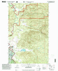
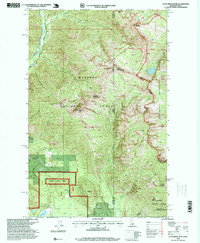
 1996 Caribou Creek1999 Print · USGSThe Idaho Panhandle during the late 1990s remained a stronghold of high-country wilderness and forest management. Researchers can trace the rugged topography of Bugle Ridge and locate remote landmarks like Lookout Mountain and Armstrong Meadows.
 - 1996 Map of Scotchman Peak, 1999 Print
 1996 Scotchman Peak1999 Print · USGSThe Cabinet Mountains wilderness comes alive in this late-1990s survey of the Idaho-Montana borderlands. Topographical researchers can trace the high ridges of Scotchman Peak and Goat Mountain or locate remote landmarks like the Open Pit Mine and Little Spar Lake.
 - 1996 Map of Laclede, 1999 Print
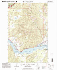 1996 Laclede1999 Print · USGSAlong the shores of the Pend Oreille River in the late nineties, this area was a hub of timber production and wildlife management. Researchers can trace the industrial footprint of the Sawmill in Laclede or find family history at the Seneacquoteen Cemetery.
 - 1996 Map of Trestle Peak, 1999 Print
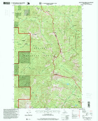
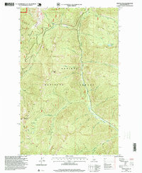 1996 Trestle Peak1999 Print · USGSBonner County, Idaho, is shown in the late nineties as a landscape defined by timber and mining interest. Historians and hikers can trace the Alpine Trail through the Auxor Basin and locate the Auxor Mine or the remote Char Falls.
 - 1996 Map of Sagle, 1999 Print
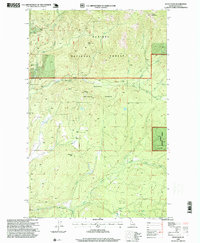
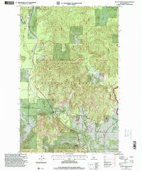
 1996 Sagle1999 Print · USGSBonner County in the late nineties is captured here as the timber and rail economy shaped the landscape south of Sandpoint. Genealogists and local historians can locate early settlements like Dufort, trace the Union Pacific line, and find the Westmond Cemetery.
 - 1996 Map of Priest Lake NW, 1999 Print
 1996 Priest Lake NW1999 Print · USGSThe Kaniksu National Forest backcountry near the Washington border comes alive in the 1990s as a mix of mountain wilderness and lakeside activity. Locate the Nickelplate Mine, trace old paths through Bismarck Meadows, and explore the shoreline at Distillery Bay.
 - 1996 Map of Gleason Mountain, 1999 Print
 1996 Gleason Mountain1999 Print · USGSThe northern borderlands of Washington and Idaho are captured in the 1990s as a landscape of timber and mining. Trace old claims at the Last Chance Mine or explore the drainage of Kalispell Creek and the Bath Creek Gorge.
 - 1996 Map of Mount Spokane, 1999 Print
 1996 Mount Spokane1999 Print · USGSThe high peaks of the Selkirk Mountains are captured here in the late nineties, showing the intersection of state parklands and the Washington-Idaho border. Researchers can trace recreational development at Vista House or locate local landmarks like Camp Fosseen and the mine near Quartz Mountain.
 - 1996 Map of Sandpoint, 1999 Print
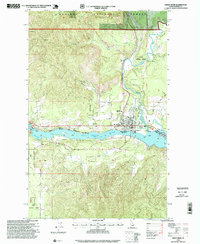
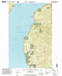
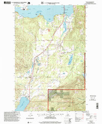
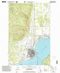 1996 Sandpoint1999 Print · USGSSandpoint and the shores of Lake Pend Oreille are captured in the mid-nineties as the region expanded. Genealogists and local historians can trace the town's growth through its grid of schools, churches, and civic sites like Lakeview Cemetery and the Memorial Park Historical Museum.
 - 1996 Map of Hope, 1999 Print
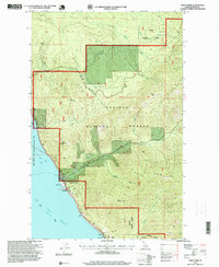
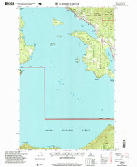 1996 Hope1999 Print · USGSThe northern shores of Lake Pend Oreille come into focus in the mid-1990s, centered on the lakeside communities of Hope and East Hope. Researchers can trace local landmarks like the Green Monarch Mine, the Lighthouse on Pearl Island, and the old Cem overlooking the bay.
Showing maps 1-25 of 56
Top cities of Bonner County
- Sandpoint historical maps
- Priest River historical maps
- Ponderay historical maps
- Clark Fork historical maps
- Dover historical maps
- Kootenai historical maps
See more
Frequently asked questions
- What are the different types of historical maps available for Bonner County?
- What is the oldest map of Bonner County?
- Where can I purchase historical maps of Bonner County for my home or office?
- Where can I download high-res historical maps of Bonner County?
- Are there historical topographic maps available for Bonner County?
- Is there historical aerial imagery available for Bonner County?
- Where are historical maps of Bonner County sourced from?