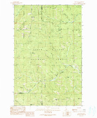
1990 Map of Faset Peak
USGS Topo · Published 1991About this map
The intersection of Shoshone, Bonner, and Kootenai counties defines this mountainous area within the Kaniksu and Coeur d'Alene National Forests. Centered on Faset Peak, the landscape is a network of ridges and drainages where Spruce Creek and Gold Creek carve deep valleys through the timber. The presence of Independence and Meadows suggests pockets of human activity or historical settlement sites tucked away from the more prominent peaks like Magee Peak and Griffith Peak.
Find a feature on this map
46 named features on this map. Tap any name to fly to it.
Don’t see what you’re looking for? This feature index may not catch every label — zoom into the map to look around manually.
Map Details
Editions of this 1990 Faset Peak Map
This is the sole edition of this map. No revisions or reprints were ever made.
Other maps of this area

1909 · Cataldo
USGS Topo · 1:125,000

1911 · Cataldo
USGS Topo · 1:125,000

1911 · Priest Lake
USGS Topo · 1:250,000

1913 · Priest Lake
USGS Topo · 1:250,000

1949 · Packsaddle Mtn
USGS Topo · 1:62,500

1951 · Packsaddle Mtn
USGS Topo · 1:62,500

1951 · Clark Fork
USGS Topo · 1:62,500

1955 · Spokane
USGS Topo · 1:250,000

1958 · Spokane
USGS Topo · 1:250,000

1958 · Sandpoint
USGS Topo · 1:250,000