1940s Maps of Idaho Falls, Idaho
Explore 6 historic maps of Idaho Falls from the 1940s. These maps offer a rare glimpse into what life looked like during the 1940s — showing old roads, neighborhoods, homes, and landmarks that have changed or disappeared over time.
Whether you're researching your family's past, planning a metal detecting trip, or studying how Idaho Falls's landscape evolved across the 1940s, these high-resolution maps are a powerful tool for exploring the history of this region.
- Focus on a specific era: All maps on this page are from the 1940s, giving you a focused view of this time period.
- See what’s changed: Compare century-old streets, trails, and buildings to today's modern landscape using overlays and satellite layers.
- Research with precision: Use these maps for genealogy, historical research, land use analysis, or educational projects.
- View, download, or print: Maps are fully viewable online in high resolution, and can be downloaded or printed for your own records.
Start exploring Idaho Falls's history through authentic maps from the 1940s. This is your window into the past.
Idaho Falls, ID maps
(6)- 1948 Map of Idaho Falls North, 1962 Print
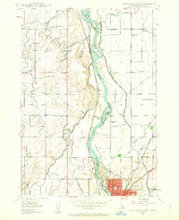 1948 Idaho Falls North1962 Print · USGSIdaho Falls and the surrounding Bonneville County farmlands are seen here just after the war, when irrigation transformed the valley. Genealogists can locate family landmarks like the Coltman Ward Church, St Leon Grange, and rural sites like Payne and Orvin.4 unique versions available
 - 1948 Map of Idaho Falls South, 1965 Print
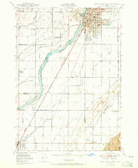 1948 Idaho Falls South1965 Print · USGSIn the late 1940s, the area south of Idaho Falls was a thriving agricultural valley defined by a sophisticated irrigation network and the SNAKE RIVER. Genealogists and local historians can trace rural school districts like Stanton Sch and York Sch, alongside landmarks such as the LDS Temple and Fielding Memorial Cem.3 unique versions available
 - 1948 Map of Ucon, 1973 Print
 1948 Ucon1973 Print · USGSUpper Snake River Plain settlements and irrigation networks are shown in detail during the late nineteen-forties. Genealogists and local historians can trace family-named water rights and rural landmarks from St Leon School to Iona and the Lincoln Cem.3 unique versions available
 - 1949 Map of Ucon
 1949 Ucon1949 Print · USGSThe agricultural heart of Bonneville County comes alive in this late-1940s survey of the canal-fed plains north of Idaho Falls. Genealogists and local historians can trace family-named waterworks like Norton Ditch alongside landmarks like St Leon School and Lincoln Cem.
 - 1949 Map of Idaho Falls North
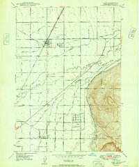
 1949 Idaho Falls North1949 Print · USGSNorth of Idaho Falls in the late 1940s, the Snake River powered a growing agricultural and transit hub. Researchers can trace the development of rural life through the Coltman Ward Church, Sage Creek School, and the vast network of the Great Western Canal.
 - 1949 Map of Roberts, 1959 Print
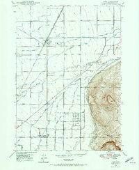
 1949 Roberts1959 Print · USGSThe Upper Snake River Plain comes alive in the late 1940s, showing a landscape defined by industrial irrigation and rail-side settlements. Genealogists and historians can trace the foundations of local communities at Lewisville Cem, Grant Sch, and Oakland Valley.
End of results
Showing maps 1-6 of 6
Top cities near Idaho Falls
- Ammon historical maps
- Rigby historical maps
- Iona historical maps
- Ucon historical maps
- Menan historical maps
- Roberts historical maps
See more
Top neighborhoods of Idaho Falls
- North Idaho Falls historical maps
- South Idaho Falls historical maps
- Downtown historical maps
- Snake River Landing historical maps
- West Idaho Falls historical maps
Frequently asked questions
- What are the different types of historical maps available for Idaho Falls?
- What is the oldest map of Idaho Falls?
- Where can I purchase historical maps of Idaho Falls for my home or office?
- Where can I download high-res historical maps of Idaho Falls?
- Are there historical topographic maps available for Idaho Falls?
- Is there historical aerial imagery available for Idaho Falls?
- Where are historical maps of Idaho Falls sourced from?